Rancho Park, Los Angeles

Last updated
Rancho Park
St. Timothy's Catholic Church, Pico & Beverly Glen, Los Angeles.JPG
Location map Western Los Angeles.png
Red pog.svg
Rancho Park
Location within Western Los Angeles
Coordinates: 34°02′30″N118°25′29″W / 34.04167°N 118.42472°W / 34.04167; -118.42472 Coordinates: 34°02′30″N118°25′29″W / 34.04167°N 118.42472°W / 34.04167; -118.42472
Country United States
State California
County Los Angeles
City Los Angeles

Rancho Park is a residential neighborhood in the Westside of the city of Los Angeles, California with mostly single family homes and tree lined streets. The community is nestled between West Los Angeles and Cheviot Hills. This enclave draws young professionals and families and is home to residents working in a variety of professional occupations. History proves the neighborhood was once a part of Westwood until Olympic Blvd. was placed dividing the area North and South. The Southern section, now known as Rancho Park, felt cut off from its North side lobbying for its own identity in the 1930s.

Contents

Etymology

Rancho Park was named by area boosters after World War II.

We thought it was about time to have our own community. We must separate ourselves from Westwood. There were many names suggested for our new community but there was a pioneer real estate broker here who had established his office on Pico near Manning back in 1927. His name was Bill Heyler. Bill did as much as any other one person to develop the area; so when it came time to adopting a name for the community, the wisdom of our pioneer was in counsel. The honor of naming this community "Rancho Park" went to Bill Heyler. [1] Heyler is also credited with bringing in the Rancho Park Golf Course, which opened in 1947. [2]

Geography

It is bordered by Sawtelle on the west, West Los Angeles on the northwest, Cheviot Hills on the east, and Westside Village on the south. The district's boundaries, while somewhat ill-defined, are generally considered to be the San Diego Freeway (I-405) or Sepulveda on the west, Olympic Boulevard on the north, Manning Avenue (south of Pico Boulevard) and Beverly Glen Boulevard (north of Pico) on the east, and National Boulevard on the south. (Los Angeles City signs mark Olympic Boulevard as the district's northern boundary.) Major thoroughfares include Pico, Westwood, Olympic, Sepulveda, and Beverly Glen Boulevards, along with Overland and Manning Avenues. Nearby is Santa Monica Boulevard. Century City is also located nearby.

History

Rancho Park was developed in the 1920s as a middle-class area, and most of its housing stock consists of Spanish Colonial bungalows and ranch houses. Today, many of the modest sized homes have been rehabbed into larger and more modern architecture. Apart from the heavily traveled stretch of Pico Boulevard (including the Westside Pavilion shopping mall) in its central portions, the district has a notably quiet, suburban feel. The district's streets are equipped with faux 19th-century streetlights and feature large deciduous trees in the strips between the sidewalk and the street. (Rancho Park is one of the few districts in Los Angeles where fall foliage can be seen.) The enclave is centrally located to other Westside communities.

Demographics

In 2009, the Los Angeles Times's "Mapping L.A." project supplied these Rancho Park neighborhood statistics: population: 5,464; median household income: $78,116. [3]

Government

Palms-Rancho Park branch library in Los Angeles (California) Public Library system. Palms-Rancho Park Branch Library.jpg
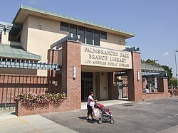
Palms–Rancho Park branch library in Los Angeles (California) Public Library system.

The Los Angeles County Department of Health Services SPA 5 West Area Health Office serves Rancho Park. [4] Los Angeles Police Department operates the West Los Angeles Community Police Station serving the neighborhood. [5]

Education

Rancho Park is served by Los Angeles USD schools:

Private school:

Charter school:

Los Angeles Public Library operates the Palms–Rancho Park Branch. [6]

Recreation

The municipal Rancho Park Golf Course includes an 18-hole layout par 71 championship course. The park has Back Nine Play, a banquet room, a cart rental, a clubhouse, a lighted driving range, lessons, locker rooms for men and women, practice putting greens, a pro shop, rental clubs, and a snack bar. [7] Two people have tied the course record of 61 (–10) at the par-71 course. The junior record is 64 (–7) by Tiger Woods in 1989, at the age of 13. The senior record is held by James White, who shot a 65 (–6) in the Los Angeles Senior City Championship in August 1998.[ citation needed ]

Related Research Articles

<span class="mw-page-title-main">Westwood, Los Angeles</span> Neighborhood of Los Angeles in California, United States

Westwood is a commercial and residential neighborhood in the northern central portion of the Westside region of Los Angeles, California. It is the home of the University of California, Los Angeles (UCLA). Bordering the campus on the south is Westwood Village, a major regional district for shopping, dining, movie theaters, and other entertainment.

<span class="mw-page-title-main">Encino, Los Angeles</span> Neighborhood of Los Angeles in California, United States

Encino is a neighborhood in the San Fernando Valley region of Los Angeles, California.

<span class="mw-page-title-main">Westchester, Los Angeles</span> Neighborhood of Los Angeles

Westchester is a neighborhood in the City of Los Angeles and the Westside Region of Los Angeles County, California.

<span class="mw-page-title-main">Century City</span> Neighborhood of Los Angeles in California, United States

Century City is a 176-acre neighborhood and business district in Los Angeles, California. Located on the Westside to the south of Santa Monica Boulevard around 10 miles (16 km) west of Downtown Los Angeles, Century City is one of the most prominent employment centers in the Los Angeles metropolitan area, and its skyscrapers form a distinctive skyline on the Westside.

<span class="mw-page-title-main">Palms, Los Angeles</span> Neighborhood of Los Angeles, California,

Palms is a community in the Westside region of Los Angeles, California, founded in 1886 and the oldest neighborhood annexed to the city, in 1915. The 1886 tract was marketed as an agricultural and vacation community. Today it is a primarily residential area, with many apartment buildings, ribbons of commercial zoning and a single-family residential area in its northwest corner. As of the 2000 census the population of Palms was 42,545.

The Los Angeles Westside is an urban region in western Los Angeles County, California. It has no official definition, but sources like LA Weekly and the Mapping L.A. survey of the Los Angeles Times place the region on the western side of the Los Angeles Basin south of the Santa Monica Mountains.

North Hills, known previously as Sepulveda, is a neighborhood in the San Fernando Valley region of the City of Los Angeles.

Beverlywood is a neighborhood in the Westside of the city of Los Angeles, California.

<span class="mw-page-title-main">Pico-Union, Los Angeles</span> Neighborhood of Los Angeles in California, United States of America

Pico-Union is a neighborhood in Central Los Angeles, California. The name "Pico-Union" refers to the neighborhood that surrounds the intersection of Pico Boulevard and Union Avenue. Located immediately west of Downtown Los Angeles, it is home to over 40,000 residents.

West Los Angeles is an area within the city of Los Angeles, California. The residential and commercial neighborhood is divided by the Interstate 405 freeway, and each side is sometimes treated as a distinct neighborhood, mapped differently by different sources. Each lies within the larger Westside region of Los Angeles County.

<span class="mw-page-title-main">Baldwin Hills, Los Angeles</span> Neighborhood of Los Angeles in California, United States

Baldwin Hills is a neighborhood within the South Los Angeles region of Los Angeles, California. It is home to Kenneth Hahn State Regional Park and to Village Green, a National Historic Landmark.

<span class="mw-page-title-main">Mid City, Los Angeles</span> Neighborhood of Los Angeles in California, United States of America

Mid City is a neighborhood in Central Los Angeles, California.

<span class="mw-page-title-main">Lake Balboa, Los Angeles</span> Neighborhood of Los Angeles in California, United States

Lake Balboa is a neighborhood in the San Fernando Valley region of Los Angeles, California. The area was previously part of Van Nuys.

<span class="mw-page-title-main">South Robertson, Los Angeles</span> Neighborhood of Los Angeles in California, United States

South Robertson is a neighborhood in the Westside of the city of Los Angeles, California. It is notable for its diversity and being a center for the Jewish community.

Pico Boulevard is a major Los Angeles street that runs from the Pacific Ocean at Appian Way in Santa Monica to Central Avenue in Downtown Los Angeles, California, USA. It is named after Pío Pico, the last Mexican governor of Alta California.

<span class="mw-page-title-main">Beverly Glen Boulevard</span>

Beverly Glen Boulevard is one of five major routes that connect the Westside of Los Angeles to the San Fernando Valley (the other four are the San Diego Freeway, Sepulveda Boulevard, Laurel Canyon Boulevard, and Coldwater Canyon Avenue.

Cheviot Hills is a neighborhood on the Westside of the city of Los Angeles, California.

<span class="mw-page-title-main">Los Angeles City Council District 5</span> American legislative district

Los Angeles City Council District 5 is one of the 15 districts of the Los Angeles City Council. District 5 represents Los Angeles communities in the Westside, central-eastern Santa Monica Mountains, and central-southern San Fernando Valley. Katy Young Yaroslavsky is the current council member.

<span class="mw-page-title-main">Castle Heights, Los Angeles</span> Neighborhood of Los Angeles in California, United States

Castle Heights is a neighborhood on the Westside of the city of Los Angeles, California.

References

  1. Gail B. McKay, quoted in "History of the Golden Westside, Book One, by Ralph Brogdon, The Rancho Park Story, Chapter One," Citizen-News, August 31, 1967
  2. Spitz, H. May (April 4, 2004). "Pancakes, putting green just around the corner". LAT Home, Collections, Los Angeles, Neighborly Advice. Los Angeles Times. Retrieved Oct 22, 2011.
  3. "Rancho Park" entry on the Los Angeles Times "Mapping L.A." website
  4. "About Us." Los Angeles County Department of Health Services. Retrieved on March 18, 2010.
  5. West LA Community Police Station – official website of THE LOS ANGELES POLICE DEPARTMENT
  6. "Palms-Rancho Park Branch Library." Los Angeles Public Library. Retrieved on March 23, 2010.
  7. Home page Archived 2010-04-04 at the Wayback Machine . Rancho Park Golf Course. Retrieved on March 23, 2010.