Howard Robard Hughes Jr. was an American aerospace engineer, business magnate, film producer, investor, philanthropist and aircraft pilot. He was best known during his lifetime as one of the richest and most influential people in the world. He first became prominent as a film producer, and then as an important figure in the aviation industry. Later in life, he became known for his eccentric behavior and reclusive lifestyle—oddities that were caused in part by his worsening obsessive-compulsive disorder (OCD), chronic pain from a near-fatal plane crash, and increasing deafness.

Culver City is a city in Los Angeles County, California, United States. As of the 2020 census, the population was 40,779. It is mostly surrounded by Los Angeles, but also shares a border with the unincorporated area of Ladera Heights to the east. The city was named after its founder, Harry Culver, who first attempted to establish it in 1913.

The Hughes H-4 Hercules is a prototype strategic airlift flying boat designed and built by the Hughes Aircraft Company. Intended as a transatlantic flight transport for use during World War II, it was not completed in time to be used in the war. The aircraft made only one brief flight, on November 2, 1947, and the project never advanced beyond the prototype.

Hollywood Burbank Airport — formerly called Bob Hope Airport after entertainer Bob Hope — is a public airport three miles (4.8 km) northwest of downtown Burbank, in Los Angeles County, California, United States. The airport serves Burbank, Hollywood, and the northern Greater Los Angeles area, which includes Glendale, Pasadena, the San Fernando Valley and the Santa Clarita Valley. It is closer to many popular attractions, including Griffith Park, Universal Studios Hollywood, and Downtown Los Angeles, than Los Angeles International Airport (LAX), and it is the only airport in the area with a direct rail connection to Downtown Los Angeles, with service from two stations: Burbank Airport–North and Burbank Airport–South. Nonstop flights mostly serve cities in the western United States, though Delta Air Lines has regular routes to Atlanta.

Oxnard Airport is a county-owned, public airport a mile west of downtown Oxnard, in Ventura County, California. The airport has not had scheduled passenger service since June 8, 2010, when United Express ended flights to Los Angeles International Airport. America West Express also served the airport with nonstop flights to Phoenix in the early-2000s via a code sharing agreement with America West Airlines.

The Hughes Aircraft Company was a major American aerospace and defense contractor founded on February 14, 1934 by Howard Hughes in Glendale, California, as a division of Hughes Tool Company. The company produced the Hughes H-4 Hercules aircraft, the atmospheric entry probe carried by the Galileo spacecraft, and the AIM-4 Falcon guided missile.

Playa del Rey is a seaside neighborhood on the westside of Los Angeles in the Santa Monica Bay region of Los Angeles County, California. It has a ZIP Code of 90293 and area codes of 310 and 424. As of 2018, the community had a population of 16,230 people.

Westchester is a neighborhood in the City of Los Angeles and the South Bay region of Los Angeles County, California, United States.

The Aviator is a 2004 American epic biographical drama film directed by Martin Scorsese and written by John Logan. It stars Leonardo DiCaprio as Howard Hughes, Cate Blanchett as Katharine Hepburn, and Kate Beckinsale as Ava Gardner. The supporting cast features Ian Holm, John C. Reilly, Alec Baldwin, Jude Law, Gwen Stefani, Kelli Garner, Matt Ross, Willem Dafoe, Alan Alda, and Edward Herrmann.

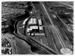
Playa Vista is a neighborhood in the Westside area of Los Angeles, California, United States. The area was the headquarters of Hughes Aircraft Company from 1941 to 1985 and the site of the construction of the Hughes H-4 Hercules "Spruce Goose" aircraft. The area began development in 2002 as a planned community with residential, commercial, and retail components. The community attracted businesses in technology, media and entertainment and is part of Silicon Beach.

The Amazing Howard Hughes is a 1977 American made-for-television biographical film about American aviation pioneer and filmmaker Howard Hughes, based on the book Howard: The Amazing Mr. Hughes by Hughes' business partner Noah Dietrich. The film starred Tommy Lee Jones, Ed Flanders, and Tovah Feldshuh. The Amazing Howard Hughes recounts the life and times of Howard Hughes and was made within a year of Hughes's death in April 1976. It was originally broadcast in two parts on CBS on April 13 and 14, 1977.

Ballona Creek is an 8.5-mile (13.7 km) channelized stream in southwestern Los Angeles County, California, United States, that was once a "year-round river lined with sycamores and willows". The urban watercourse begins in the Mid-City neighborhood of Los Angeles, flows through Culver City and Del Rey, and passes the Ballona Wetlands Ecological Preserve, the sailboat harbor Marina del Rey, and the small beachside community of Playa del Rey before draining into Santa Monica Bay. The Ballona Creek drainage basin carries water from the Santa Monica Mountains on the north, from the Baldwin Hills to the south, and as far as the Harbor Freeway (I-110) to the east.

Ballona Wetlands Ecological Reserve is a protected area that once served as the natural estuary for neighboring Ballona Creek. The 577-acre (2.34 km2) site is located in Los Angeles County, California, just south of Marina del Rey. Ballona—the second-largest open space within the city limits of Los Angeles, behind Griffith Park—is owned by the state of California and managed by the California Department of Fish and Wildlife. The preserve is bisected generally east-west by the Ballona Creek channel and bordered by the 90 Marina freeway to the east.

Westside Village is a neighborhood on the west side of Los Angeles, California.
Paso Robles Municipal Airport is four miles (6.4 km) northeast of downtown Paso Robles, in San Luis Obispo County, California, United States.

McMinnville Municipal Airport is three miles southeast of McMinnville, in Yamhill County, Oregon. The FAA's National Plan of Integrated Airport Systems for 2009–2013 categorized it as a general aviation facility. It is across Oregon Route 18 from the Evergreen Aviation & Space Museum, home to the Hughes H-4 Hercules Spruce Goose flying boat.

Grand Central Airport is a former airport in Glendale, California. Also known as Grand Central Air Terminal (GCAT), the airport was an important facility for the growing Los Angeles suburb of Glendale in the 1920s and a key element in the development of United States aviation. The terminal, located at 1310 Air Way, was built in 1928 and still exists, owned since 1997 by The Walt Disney Company as a part of its Grand Central Creative Campus (GC3). Three hangars also remain standing. The location of the single concrete 3,800-foot (1,200 m) runway has been preserved, but is now a public street as the runway was dug up and converted into Grand Central Avenue.
Alsace is a place name designating what was originally an interurban trolley stop, and now an approximately five-block enclave of unincorporated Los Angeles County in the Westside region, surrounded by Del Rey, just north of the Playa Vista neighborhood of Los Angeles, California, United States.

The Venice–Inglewood Line is a former railway line in Los Angeles County, California. The route was established by the Atchison, Topeka and Santa Fe Railway in 1887 before eventually being absorbed into the Pacific Electric interurban railway system. Service under electrification was very sparse, providing a suburban route between Venice and Inglewood.

Naval Air Station Los Alamitos Naval Outlying Landing Fields were a set airfield near Naval Air Station Los Alamitos to support the training of US Navy pilots during World War 2. The support airfields are called Naval Outlying Landing Field (NOLF). For the war, many new trained pilots were needed. The Naval Outlying Landing Fields provided a place for pilots to practice landing and take off without other air traffic. The remotes sites offered flight training without distractions. Most of the new pilots departed to the Pacific War after training. The Outlying Landing Fields had little or no support facilities. Naval Air Station Los Alamitos opened in 1942 and was transferred to the US Army in 1977 as Los Alamitos Army Airfield. Most of the Outlying fields closed in 1945, having completed the role of training new pilots. To open the needed Outlying Landing Fields quickly, the Navy took over local crop dusting and barnstorming airfields. Naval Air Station Los Alamitos was also called Los Alamitos Naval Reserve Air Base. During the war Marine Corps Air Station El Toro also used the outlying Landing Field. The Timm N2T Tutor was the most common plane used for training on the outlying landing fields.