
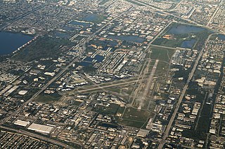
Akron–Canton Airport is a commercial airport in the city of Green, in southern Summit County, Ohio. The airport is located about 14 miles (23 km) southeast of Akron and 10 miles (16 km) northwest of Canton. It is jointly operated by Summit County and Stark County. The airport is a "reliever" airport for Northeast Ohio and markets itself as "A better way to go", emphasizing the ease of travel in comparison to Cleveland Hopkins International Airport. Just under 90% of its traffic is general aviation. It is included in the Federal Aviation Administration (FAA) National Plan of Integrated Airport Systems for 2019–2023, in which it is categorized as a small-hub primary commercial service facility.

Santa Monica Airport is a general aviation airport largely in Santa Monica, California, United States, in the Greater Los Angeles area. It opened on April 15, 1928, making it one of the United States' oldest airports, and it has been one of the world's foremost general aviation airports.
Fort Lauderdale Executive Airport is a general aviation airport located within the city limits of Fort Lauderdale, in Broward County, Florida, United States, five miles (8.0 km) north of downtown Fort Lauderdale. It is a division of the Transportation and Mobility Department of the City of Fort Lauderdale.

Troutdale Airport, also known as Troutdale-Portland Airport, is a corporate, general aviation, and flight-training airport serving the city of Troutdale, in Multnomah County, Oregon, United States. It is one of three airports in the Portland metropolitan area owned and operated by the Port of Portland. Troutdale Airport was established in 1920 as a private airfield, then purchased by the Port of Portland in 1942. It serves as a reliever airport for nearby Portland International Airport (PDX).

Addison Airport is a public airport in Addison, in Dallas County, Texas, United States, 9 mi north of downtown Dallas. It opened in 1954 and was purchased by the town of Addison in 1976.

Monroe County Airport is a county-owned public-use airport located four nautical miles southwest of the central business district of Bloomington, a city in Monroe County, Indiana, United States. Commercial service has been available at different points in the airport's history but as of today and for the future, no scheduled service is available.

Springfield–Beckley Municipal Airport is a civil-military airport five miles (8 km) south of Springfield, in Clark County, Ohio, United States. It is owned by the city of Springfield. It is named after the Beckley family, a member of which knew the Wright Brothers, and witnessed and photographed their first flights.

Montgomery-Gibbs Executive Airport is a public airport in San Diego, California, United States, six miles (10 km) north of downtown San Diego. The airport covers 456 acres (185 ha) and has three runways, one public helipad, and two private helipads. The runways are 28R/10L and 28L/10R (parallel) and 5/23.
Portage County Airport, also known as Portage County Regional Airport, is a public use airport in Portage County, Ohio, United States. It is owned by the Portage County Board of Commissioners and located three nautical miles (6 km) north of Ravenna, in Shalersville Township. This airport is included in the National Plan of Integrated Airport Systems for 2011–2015, which categorized it as a general aviation facility.

French Valley Airport is a county-owned public-use airport in southwestern Riverside County, California, located on Highway 79 near the cities of Murrieta and Temecula.
Newark–Heath Airport is a public airport located in Heath, Ohio. It is three miles (4.8 km) southwest of the central business district of Newark, a city in Licking County, Ohio, United States. The airport was opened in 1930 by the city of Newark, and was transferred to the Licking County Regional Airport Authority in 1967. The airport currently has a McDonnell Douglas F-4C Phantom II S.N. 64–0683 on static display.
Madison County Airport is a public airport located 3 miles (4.8 km) north of the central business district of London, a city in Madison County, Ohio, United States. It is owned by the Madison County Airport Authority.

Union County Airport is a public use airport in Union County, Ohio, United States. It is owned by the Union County Airport Authority and located one nautical mile (2 km) southeast of the central business district of Marysville, Ohio. This airport is included in the National Plan of Integrated Airport Systems for 2011–2015, which categorized it as a general aviation facility.
Romeo State Airport is a public airport owned and operated by the State of Michigan located 2 miles (3.2 km) east of Romeo, Michigan, United States. The airport is uncontrolled and is used for general aviation purposes. It is included in the Federal Aviation Administration (FAA) National Plan of Integrated Airport Systems for 2017–2021, in which it is categorized as a local reliever airport facility.
Fairfield County Airport is a public use airport in Fairfield County, Ohio, United States. It is located three nautical miles (6 km) northwest of the central business district of Lancaster, the county seat. The airport is owned by the Fairfield County Commissioners.

Grimes Field is a city-owned public-use airport located one nautical mile (1.85 km) north of the central business district of Urbana, a city in Champaign County, Ohio, United States. The airport is named after Warren G. Grimes, a forefather in the field of aviation lighting, and his Grimes Manufacturing Company operated the airport until 1987. It primarily serves general aviation traffic. Although it is owned by the City of Urbana, Grimes Field is self-supporting.
Highland County Airport is a public-owned, public-use airport located at 9500 North Shore Drive three nautical mile (4.8 km) southeast of the central business district of the city of Hillsboro, in Highland County, Ohio, United States.
Carroll County–Tolson Airport is a county–owned, public-use airport located one nautical mile (1.85 km) southeast of the central business district of Carrollton, a village in Carroll County, Ohio, United States. It is owned by the Carroll County Airport Authority. According to the FAA's National Plan of Integrated Airport Systems for 2009–2013, it is categorized as a general aviation airport.
Holmes County Airport is a public airport located two miles southwest of Millersburg, Ohio, United States. It is owned and operated by the Holmes County Airport Authority.
Sparta Community Airport, also known as Hunter Field, is a civil, public use airport 2 miles north of Sparta in Randolph County, Illinois. The airport is publicly owned by the Sparta Community Airport Authority.


