
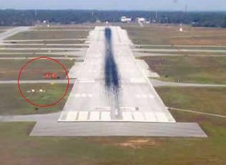
According to the International Civil Aviation Organization (ICAO), a runway is a "defined rectangular area on a land aerodrome prepared for the landing and takeoff of aircraft". Runways may be a man-made surface or a natural surface. Runways, taxiways and ramps, are sometimes referred to as "tarmac", though very few runways are built using tarmac. Takeoff and landing areas defined on the surface of water for seaplanes are generally referred to as waterways. Runway lengths are now commonly given in meters worldwide, except in North America where feet are commonly used.

In aviation, the instrument landing system (ILS) is a precision radio navigation system that provides short-range guidance to aircraft to allow them to approach a runway at night or in bad weather. In its original form, it allows an aircraft to approach until it is 200 feet (61 m) over the ground, within a 1⁄2 mile (800 m) of the runway. At that point the runway should be visible to the pilot; if it is not, they perform a missed approach. Bringing the aircraft this close to the runway dramatically increases the range of weather conditions in which a safe landing can be made. Other versions of the system, or "categories", have further reduced the minimum altitudes, runway visual ranges (RVRs), and transmitter and monitoring configurations designed depending on the normal expected weather patterns and airport safety requirements.

A heliport is a small airport suitable for use by helicopters and some other vertical lift aircraft. Designated heliports typically contain one or more touchdown and liftoff areas and may also have limited facilities such as fuel or hangars. In some larger towns and cities, customs facilities may also be available.

A taxiway is a path for aircraft at an airport connecting runways with aprons, hangars, terminals and other facilities. They mostly have a hard surface such as asphalt or concrete, although smaller general aviation airports sometimes use gravel or grass.

Laughlin/Bullhead International Airport is a public use airport located 1.15 miles north of the central business district of Bullhead City, in Mohave County, Arizona, United States. It is owned by Mohave County. The airport is across the Colorado River and one block away from Laughlin, Nevada. Many of the rooms at Laughlin's casino-hotels offer a view of the airport. It was named 2011 Airport of the Year by the Arizona Department of Transportation.
The visual approach slope indicator (VASI) is a system of lights on the side of an airport runway threshold that provides visual descent guidance information during approach. These lights may be visible from up to 8 kilometres (5.0 mi) during the day and up to 32 kilometres (20 mi) or more at night.

A precision approach path indicator (PAPI) is a visual aid that provides guidance information to help a pilot to acquire and maintain the correct approach to an airport or an aerodrome. It is generally located on the left-hand side of the runway approximately 300 meters beyond the landing threshold of the runway.
A Notice to Airmen/Notice to Air Men/Notice to Airman/Notice to Air Missions (NOTAM) is a notice filed with an aviation authority to alert aircraft pilots of potential hazards along a flight route or at a location that could affect the flight. NOTAMs are notices or advisories that contain information concerning the establishment, conditions or change in any aeronautical facility, service, procedure or hazard, the timely knowledge of which may be essential to personnel and systems concerned with flight operations. NOTAMs are created and transmitted by government agencies and airport operators under guidelines specified by Annex 15: Aeronautical Information Services of the Convention on International Civil Aviation (CICA). The acronym NOTAM came into common use following the ratification of the CICA, which came into effect on 4 April 1947. Notices to airmen were normally published in a regular publication by each country's air authorities. Several developments and amendments to the CICA have resulted in the more automated system available today.
Pilot-controlled lighting (PCL), also known as aircraft radio control of aerodrome lighting (ARCAL) or pilot-activated lighting (PAL), is a system that allows aircraft pilots to control the lighting of an airport or airfield's approach lights, runway edge lights, and taxiways via radio.

In aviation, an instrument approach or instrument approach procedure (IAP) is a series of predetermined maneuvers for the orderly transfer of an aircraft operating under instrument flight rules from the beginning of the initial approach to a landing, or to a point from which a landing may be made visually. These approaches are approved in the European Union by EASA and the respective country authorities and in the United States by the FAA or the United States Department of Defense for the military. The ICAO defines an instrument approach as, "a series of predetermined maneuvers by reference to flight instruments with specific protection from obstacles from the initial approach fix, or where applicable, from the beginning of a defined arrival route to a point from which a landing can be completed and thereafter, if landing is not completed, to a position at which holding or en route obstacle clearance criteria apply."

In aviation, the runway visual range (RVR) is the distance over which a pilot of an aircraft on the centreline of the runway can see the runway surface markings delineating the runway or identifying its centre line. RVR is normally expressed in meters or feet. RVR is used to determine the landing and takeoff conditions for aircraft pilots, as well as the type of operational visual aids used at the airport.
Clinton County Airport is a former county-owned public-use airport in Clinton County, New York, United States. It is located 3 nautical miles west of the central business district of the city of Plattsburgh. It served Plattsburgh and the western side of Lake Champlain.
East Texas Regional Airport is an airport located in Gregg County, Texas. The airport is just South of the city of Lakeport, and is 9 mi south of Longview. Its IATA identifier GGG comes from its prior name, Gregg County Airport. The airport is used for general aviation and military training; it has scheduled flights to Dallas/Fort Worth on American Airlines/American Eagle.
Iowa City Municipal Airport, is two miles southwest of downtown Iowa City, in Johnson County, Iowa. It is the oldest civil airport west of the Mississippi River still in its original location.
Safford Regional Airport is in Graham County, Arizona, United States, 3 miles east of Safford, which owns it. The FAA's National Plan of Integrated Airport Systems for 2009–2013 categorizes it as a general aviation facility. It is the only paved airport in Graham County.

An approach lighting system (ALS) is a lighting system installed on the approach end of an airport runway and consisting of a series of lightbars, strobe lights, or a combination of the two that extends outward from the runway end. ALS usually serves a runway that has an instrument approach procedure (IAP) associated with it and allows the pilot to visually identify the runway environment and align the aircraft with the runway upon arriving at a prescribed point on an approach.
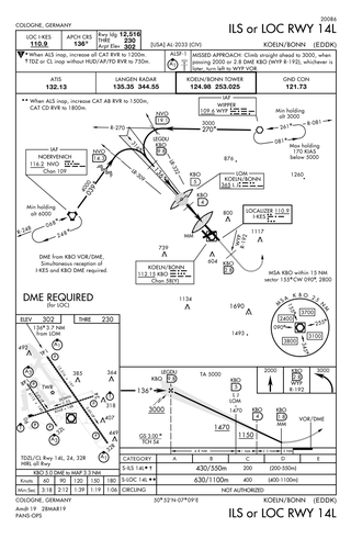
Approach plates are the printed or digital charts of instrument approach procedures that pilots use to fly instrument approaches during instrument flight rules (IFR) operations. Each country maintains its own instrument approach procedures according to International Civil Aviation Organization (ICAO) standards.

Lebanon-Warren County Airport is a public airport located three miles (5 km) northwest of the central business district of Lebanon, on Greentree Road, in Warren County, Ohio, United States.

Landing lights are lights, mounted on aircraft, that illuminate the terrain and runway ahead during takeoff and landing, as well as being used as a collision avoidance measure against other aircraft and bird strikes.

Willow Airport is a state-owned, public-use airport located one nautical mile (1.85 km) northwest of the central business district of Willow, in the Matanuska-Susitna Borough of the U.S. state of Alaska. It is located across the road from Willow Lake and the Willow Seaplane Base.
