The department also manages the Marina Del Rey small-craft harbor, which has “4,600 boat slips in 23 marinas” [2] and brings in nearly $60 million annually in revenue.[1] The Marina function was added by the Board of Supervisors in 1954.[3] The department also operates Burton Chace Park, and monitors raptor and waterbird nesting sites in Marina Del Rey's urban forest; tree trimmers wishing to work in the area must apply for a special permit.[4]
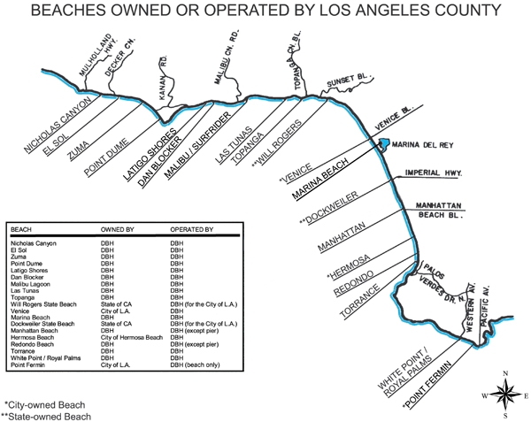
Beaches
Management of the beaches was shifted from the Parks and Recreation department in May 1969.[3][5] L.A. native Dick Fitzgerald was the first director of the Department of Beaches.[6] In 1976, Fitzgerald advocated for marine reserves to protect the tide pool ecosystems at Abalone Cove and Vista Sudeste.[7] Circa 1975, when the city of Los Angeles handed over management of the “lifeguards, maintenance, parking and concessions” at their beaches to the county, the department oversaw 73mi (117km) of the 76.5mi (123.1km) of beaches in the county, including 38mi (61km) miles of “improved beaches.”[8]
Beaches and Harbors also runs the Dockweiler Beach RV parking and campground facilities, as well as Dockweiler Youth Center.[1]
A view of Nicholas Canyon Beach from South Beach.
Misc.
“Safety operations on state waters in county territory” are also under the purview of the department.[3]
The Beaches and Harbors Dept. collaborates with the Department of Public Works in the management of Ballona Creek and watershed, Malibu Lagoon and Oxford Basin.
Los Angeles County Department of Beaches and Harbors vehicle
1 2 3 Pitt, Leonard; Pitt, Dale (1997). Los Angeles A to Z: An Encyclopedia of the City and County. Berkeley, Calif.: University of California Press. ISBN0-520-20274-0.
↑ "Department of Beaches Notes Successful Start." Los Angeles Times, Oct 26, 1969, pp. 1-ws2.
↑ Murray, Don. "County Beach Chief Pledges Aid to Surfing." Los Angeles Times, Apr 18, 1969, pp. 1-f13.
↑ Lee, Mary A. "Coastal Reserves Urged for Peninsula Tidepools." Los Angeles Times, Feb 29, 1976, pp. 1-cs2.
↑ Allan, Robert J. "Beach Merger Vote Expected on Monday: 14.1 Miles of L.A. City Shores Could Move to County Control June 1." Los Angeles Times (1923-1995), May 04, 1975, pp. 1-cs1
↑ "Westside Bay Considered for Study" Los Angeles Times, Oct 20, 1988, pp. 2.
This page is based on this Wikipedia article Text is available under the CC BY-SA 4.0 license; additional terms may apply. Images, videos and audio are available under their respective licenses.


