LAX/Metro Transit Center station (called the East ITF by LAX and known as Aviation/96th Street station during planning) is an under construction light rail transport hub in the Los Angeles Metro Rail system, located near Aviation Boulevard and 96th Street in the Westchester district of Los Angeles. The station was designed as a station for the C and K lines.[3] It will serve as the transfer point between Metro Rail and the LAX Automated People Mover (APM) serving the Los Angeles International Airportterminals and facilities. Additionally, the station will have connections to Metro Bus, other municipal bus lines, a customer service center, and a Metro Bike Share hub.[4] Metro is scheduled to start serving the station on June 6, 2025, although the APM connection is not scheduled to open until early 2026.[5][6][7]
In anticipation of a future extension to LAX, Metro constructed two concrete ramps adjacent to the Aviation/LAX C Line station. These ramps are now linked, connecting the C and K lines rails to LAX.
Various proposals have been made to connect Los Angeles International Airport (LAX) by rail since the 1960s.[8] Development of the Los Angeles Metro Rail C Line (formally the Green Line) in the late 1980s proposed extending the line north from the Aviation/LAX station towards LAX, either serving the terminals directly or nearby at Lot C, with the use of a people mover to connect to the terminal buildings.[9][10] However, these plans were canceled in 1992 following disagreements with the Federal Aviation Administration and politicians who wanted the line to focus on local communities.[10] Some advocates criticized Los Angeles World Airports (LAWA) for wishing to preserve parking revenues.[10] When the C Line opened in 1995, the closest station to the airport was 2.4 miles (3.9km) away at Aviation/LAX station, where a free LAX Shuttle was provided.[11]
In the 1990s and 2000s, the development of the Metro K Line once again considered connecting the Metro Rail system to LAX, as parts of the proposed line ran nearby on Aviation Boulevard.[8][12] The project would also connect the C Line to the K Line tracks at a new wye near the Aviation/LAX station, allowing the C Line to serve the airport.[12] Construction of the light rail line began in January 2014 without a station directly at LAX. The plan was to connect one of the line stations to the future LAX Automated People Mover, which would transport passengers directly to the airport terminals and facilities.[13]
Initially, Metro thought the K Line's Aviation/Century station would connect with the people mover (APM) with the intention that the APM would run along Century Boulevard. However, the APM plan approved in June 2014 called for it to intersect with the K Line at 96th Street, about half a mile to the north. This required Metro to design an additional station while the overall line was still under construction.[14] Later that year, Metro approved the planning and scoping of the new station, which was called Aviation/96th in planning documents but was ultimately designated LAX/Metro Transit Center station.[15] Official approval was given in December 2016, and construction began in 2021.[16][17]
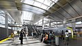
LAX/Metro Transit Center station under construction in July 2023
Designed by Grimshaw Architects,[18] the LAX/Metro Transit Center station was slated to open in late 2024.[19] Due to construction delays, the connection to the LAX Automated People Mover will open later in December 2025.[20]As of February2025[update], citing Metro’s February 2025 Schedule Update, the overall project is 96.3% complete and the primary station construction is 95.4% complete.[21] At the Metro board meeting on April 24, 2025, LA County board supervisorJanice Hahn announced that the station will open on June 6, 2025.[2] Upon opening, the station will serve both the C and K lines.[3]
Plans show a parking facility would also be built adjacent to the station. However, construction of the structure may be delayed.[22] Various planned road improvements are shown as "not triggered" in Appendix B of the LAMP 2021 Annual Progress Report.[23]
The bus plaza also features on-route fast chargers to recharge battery-electric buses.
Station artwork
This station will feature a sculpture designed by Glenn Kaino, an conceptual artist based in Los Angeles commissioned by Metro Art. Called The Distance of the Sun, the sculpture is made up of vessels joined together, creating a spiral pathway suspended in the air. These ships symbolize the universal dreams of spaceflight and represent the importance of collaboration and imagination. The piece will connect to the station's ceiling, making the ships climb to the heavens, referencing the short story The Distance of the Moon.[27]
Future Metro transit connections
Metro has proposed to make this station the southern terminus for Phase 2 of the Sepulveda Transit Corridor. Metro is in the route planning stage for Phase 1 of the corridor as of 2024[update] with completion planned for around 2040. Metro has also proposed the LAX/Metro Transit Center station as the southern terminus for the Lincoln Boulevard Transit Corridorbus rapid transit line with a completion date of 2047. Both projects are funded by Measure M.[28][29][30]
This page is based on this Wikipedia article Text is available under the CC BY-SA 4.0 license; additional terms may apply. Images, videos and audio are available under their respective licenses.