
Mount Warning, a mountain in the Tweed Range in the Northern Rivers region of New South Wales, Australia, was formed from a volcanic plug of the now-gone Tweed Volcano. The mountain is located 14 kilometres (9 mi) west-south-west of Murwillumbah, near the border between New South Wales and Queensland. Lieutenant James Cook saw the mountain from the sea and named it Mount Warning.

Coolangatta is a coastal suburb in the City of Gold Coast, Queensland, Australia. It is the Gold Coast's southernmost suburb and it borders New South Wales. In the 2016 census, Coolangatta had a population of 5,948 people.
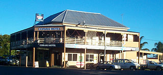
Coraki is a small town that sits on the confluence of the Richmond and Wilson Rivers in northern New South Wales, Australia in Richmond Valley Shire. At the 2016 census, Coraki had a population of 1,277 people.

Tweed Shire is a local government area located in the Northern Rivers region of New South Wales, Australia. It is adjacent to the border with Queensland, where that meets the Coral Sea. Administered from the town of Murwillumbah, Tweed Shire covers an area of 1,321 square kilometres (510 sq mi), and has existed as a local government entity since 1947. It was named for the Tweed River.
Yugambeh–Bundjalung, also known as Bandjalangic, is a branch of the Pama–Nyungan language family, that is spoken in north-eastern New South Wales and South-East Queensland.

Underwood is a suburb in the City of Logan, Queensland, Australia. In the 2016 census, Underwood had a population of 6,341 people.

Gumbaynggir language is an Australian Aboriginal language spoken by the Gumbaynggirr, who are native to the Mid North Coast of New South Wales. Gumbaynggir is the only surviving language in the Gumbaynggiric family of Pama–Nyungan stock.
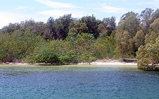
The Ukerabagh Island is a river island in the Ukerabagh Island Nature Reserve, a protected nature reserve. It is located in the mouth of the Tweed River, in the Northern Rivers region of New South Wales in eastern Australia. The 125-hectare (310-acre) reserve is situated near Tweed Heads and 1 kilometre (0.62 mi) south of a section that defines the border between the states of New South Wales and Queensland. The island and reserve is an important site for coastal birds.

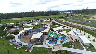
Greater Flagstone is a district and development area located within the Logan City local government area in south-east Queensland, Australia. Greater Flagstone is situated along the Sydney–Brisbane rail corridor between two future employment precincts at North Maclean and Bromelton. Greater Flagstone is expected to provide approximately 50,000 dwellings to house a population of up to 120,000 people with a development plan expected to take 30-40 years. The suburb of Flagstone was gazetted in 1997 and district suburbs were gazetted from 2016.

Tweed Heads West is a suburb of Tweed Heads, located on the Tweed River in north-eastern New South Wales, Australia, in Tweed Shire along the Queensland and New South Wales border.
Piggabeen is a town located in north-eastern New South Wales, Australia, in the Tweed Shire.
Wooyung is a small town located in the Northern Rivers Region of New South Wales. The most recent census indicated a population of 139, with a median age of 49. Wooyung means 'slow' in the local Bundjalung language, and is believed to reflect the natural tranquility of the area.
Waalubal (Wahlubal), also known as Western Bundjalung, Baryulgil, and Middle Clarence Bandjalang, is an Australian Aboriginal language spoken by the Western Bundjalung living in North-East New South Wales.
Flagstone is a suburban locality in the Greater Flagstone district of the City of Logan, Queensland, Australia. In 2018, the estimated population of Flagstone was 5,651 people.

Flinders Lakes is a rural locality in the City of Logan, Queensland, Australia. It was gazetted in May 2016.
Albert Digby Moran (1948–2020) was an Australian Aboriginal artist. His work derived inspiration from his Bundjalung ancestors in the north of New South Wales, Australia, where he remains one of the Northern Rivers' most recognised artists.

Monarch Glen is a rural locality in the City of Logan, Queensland, Australia. It is situated along the development corridor south of Brisbane in the Greater Flagstone development area

Riverbend is a rural locality in the City of Logan, Queensland, Australia. Designated as a separate locality in 2017, it will be progressively developed for residential use as the population of the city grows.
Glenlogan is a rural locality in the City of Logan, Queensland, Australia. It is part of the suburban development corridor south of Brisbane in the Greater Flagstone development area.
Silverbark Ridge is a rural locality in the City of Logan, Queensland, Australia. It is situated along the development corridor south of Brisbane in the Greater Flagstone development area and expected to become a residential area as the city's population increases.
