Duranbah, New South Wales

Last updated

Duranbah
New South Wales
Tweed Valley viewed from Duranbah.jpg
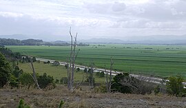
Pacific Motorway and Tweed Valley viewed from Duranbah
Australia New South Wales location map blank.svg
Red pog.svg
Duranbah
Coordinates 28°18′18″S153°31′21″E / 28.30500°S 153.52250°E / -28.30500; 153.52250 Coordinates: 28°18′18″S153°31′21″E / 28.30500°S 153.52250°E / -28.30500; 153.52250
Population262 (2011 census) [1]
Elevation65 m (213 ft)
Time zone AEST (UTC+10)
 • Summer (DST) AEDT (UTC+11)
Location
LGA(s) Tweed Shire
State electorate(s) Tweed
Federal division(s) Richmond
Localities around Duranbah:
Tumbulgum Stotts Creek Cudgen
Eviron Duranbah Kings Forest
Farrants Hill Tanglewood Cabarita Beach

Duranbah is a town located in north-eastern New South Wales, Australia, in the Tweed Shire.

Demographics

In the 2011 census, Duranbah recorded a population of 262 people, 50.4% female and 49.6% male.

The median age of the Duranbah population was 36 years, 1 year below the national median of 37.

85.2% of people living in Duranbah were born in Australia. The other top responses for country of birth were England 3.8%, New Zealand 2.3%, Scotland 1.1%, United States of America 1.1%, Indonesia 1.1%.

95% of people spoke only English at home.

Related Research Articles

<span class="mw-page-title-main">Yass Valley Council</span> Local government area in New South Wales, Australia

Yass Valley Council is a local government area in the Southern Tablelands region of New South Wales, Australia. The area is located adjacent to the Hume and Barton Highways and the Main Southern railway line.

<span class="mw-page-title-main">Holbrook, New South Wales</span> Town in New South Wales, Australia

Holbrook is a small town in Southern New South Wales, Australia. It is on the Hume Highway, 384 kilometres (239 mi) by road North-East of Melbourne and 492 kilometres (306 mi) by road south-west of Sydney between Tarcutta and Albury. The town is in the Greater Hume Shire which was established in May 2004 from the merger of Culcairn Shire with the majority of Holbrook Shire and part of the Hume Shire. At the 2016 census, Holbrook had a population of 1,715 people. The district around Holbrook is renowned for local produce including merino wool, wheat and other grains, lucerne, fat cattle and lamb.

<span class="mw-page-title-main">City of Cessnock</span> Local government area in New South Wales, Australia

City of Cessnock is a local government area in the Hunter region of New South Wales, Australia. The area under administration is located to the west of Newcastle. The largest population centre and council seat is the city of Cessnock.

<span class="mw-page-title-main">Gwydir Shire</span> Local government area in New South Wales, Australia

Gwydir Shire is a local government area located in the New England region of New South Wales, Australia. The northern boundary of the Shire is located adjacent to the border between New South Wales and Queensland.

<span class="mw-page-title-main">Rushcutters Bay, New South Wales</span> Suburb of Sydney, New South Wales, Australia

Rushcutters Bay is a harbourside inner-east suburb of Sydney, in the state of New South Wales, Australia 3 kilometres east of the Sydney central business district, in the local government area of the City of Sydney.

<span class="mw-page-title-main">Tweed Shire</span> Local government area in New South Wales, Australia

Tweed Shire is a local government area located in the Northern Rivers region of New South Wales, Australia. It is adjacent to the border with Queensland, where that meets the Tasman Sea. Administered from the town of Murwillumbah, Tweed Shire covers an area of 1,321 square kilometres (510 sq mi), and has existed as a local government entity since 1947. It was named for the Tweed River.

<span class="mw-page-title-main">Byron Shire</span> Local government area in New South Wales, Australia

Byron Shire is a local government area located in the Northern Rivers region of New South Wales, Australia. The shire is located adjacent to the Coral Sea about 50 kilometres (31 mi) south of the Queensland border. The shire, administered from the town of Mullumbimby, covers an area of 566.7 square kilometres (218.8 sq mi), and has existed as a local government entity since 1906. The shire was named for Cape Byron, itself named by Captain James Cook in May 1770 in honour of Vice-Admiral John Byron.

<span class="mw-page-title-main">Kyogle Council</span> Local government area in New South Wales, Australia

Kyogle Council is a local government area in the Northern Rivers region of New South Wales, Australia.

<span class="mw-page-title-main">Narrabri Shire</span> Local government area in New South Wales, Australia

Narrabri Shire is a local government area in the North West Slopes region of New South Wales, Australia. The Shire is located adjacent to the Namoi River and the Newell and Kamilaroi Highways.

<span class="mw-page-title-main">Ballina Shire</span> Local government area in New South Wales, Australia

Ballina Shire is a local government area in the Northern Rivers region of New South Wales, Australia. The Shire was formed on 1 January 1977 by the amalgamation of the Municipality of Ballina and Tintenbar Shire. The Shire is located adjacent to the Tasman Sea and the Pacific Highway. The council seat is located in the town of Ballina. The population of the Ballina Shire area was 44,208 in June 2018.

<span class="mw-page-title-main">Bellingen Shire</span> Local government area in New South Wales, Australia

Bellingen Shire is a local government area in the mid north coast region of New South Wales, Australia. The Shire is located adjacent to the Pacific Highway, Waterfall Way and the North Coast railway line.

<span class="mw-page-title-main">Kempsey Shire</span> Local government area in New South Wales, Australia

Kempsey Shire is a local government area in the Mid North Coast region of New South Wales, Australia.

<span class="mw-page-title-main">Inverell Shire</span> Local government area in New South Wales, Australia

Inverell Shire is a local government area in the North West Slopes region of New South Wales, Australia adjacent to the Macintyre River and the Gwydir Highway.

<span class="mw-page-title-main">Heathwood, Queensland</span> Suburb of Brisbane, Queensland, Australia

Heathwood is an outer south-western suburb in the City of Brisbane, Queensland, Australia. In the 2016 census, Heathwood had a population of 2,794 people.

<span class="mw-page-title-main">Drewvale, Queensland</span> Suburb of Brisbane, Queensland, Australia

Drewvale is an outer suburb of the City of Brisbane, Queensland, Australia. In the 2016 census, Drewvale had a population of 4,476 people.

<span class="mw-page-title-main">Doolandella, Queensland</span> Suburb of Brisbane, Queensland, Australia

Doolandella is an outer western suburb in the City of Brisbane, Queensland, Australia. In the 2016 census, Doolandella had a population of 4,817 people.

Jordanian Australians refers to Australians of Jordanian descent or a Jordan-born person who resides in Australia. According to Australia's 2011 Census there were a total of 4,621 Jordan-born people in Australia, an increase of 24.2 per cent from the 2006 Census (3,397). The vast majority of Jordanian Australians reside in the state of New South Wales.

Cashmere is a suburb in the Moreton Bay Region, Queensland, Australia. In the 2016 census, Cashmere had a population of 4,920 people.

<span class="mw-page-title-main">Condong, New South Wales</span> Village in New South Wales, Australia

Condong is a village located in north-eastern New South Wales, Australia, in the Tweed Shire.

Dunbible is a town located in north-eastern New South Wales, Australia, in the Tweed Shire.

References

  1. Australian Bureau of Statistics (31 October 2012). "Duranbah (State Suburb)". 2011 Census QuickStats. Retrieved 20 January 2014. OOjs UI icon edit-ltr-progressive.svg