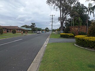
Sunnybank Hills is an outer southern suburb of the City of Brisbane, Queensland, Australia.

Kingscliff is a coastal town just south of Tweed Heads in the Northern Rivers region of New South Wales, Australia, and is a beach community offering a variety of holiday accommodations. Together with the villages of Chinderah and Fingal, it is a tourist destination that provides beach and estuary access for swimming, surfing, fishing and water sports.

Glenwood is a suburb of Sydney, in the state of New South Wales, Australia. Glenwood is located 33 kilometres north-west of the Sydney central business district in the local government area of the City of Blacktown. Glenwood is part of the Hills District and Greater Western Sydney region.

Wavell Heights is a suburb in the City of Brisbane, Queensland, Australia. In the 2016 census, Wavell Heights had a population of 9,684 people.

Tweed Shire is a local government area located in the Northern Rivers region of New South Wales, Australia. The shire is located adjacent to the border with Queensland where it meets the Tasman Sea coast. The shire, administered from the town of Murwillumbah, covers an area of 1,321.0 square kilometres (510.0 sq mi), and has existed as a local government entity since 1947. It was named for the Tweed River.

Tugun is a beach-side coastal suburb of the City of Gold Coast, Queensland, Australia. It borders New South Wales. At the 2016 census, Tugun had a population of 6,588.

Logan Central is a mixed-use suburb of Logan City, Queensland, Australia. At the 2016 census, the suburb recorded a population of 5,945.

The City of Coffs Harbour is a local government area in the mid north coast region of New South Wales, Australia. The area under administration is 1,175 square kilometres (454 sq mi), expanded in 2004 to take in parts of the former Pristine Waters local government area.

Everton Hills is a suburb in the Moreton Bay Region, Queensland, Australia

Terranora is a town located on the northern boundary of New South Wales, Australia. At the 2016 census, Terranora had a population of 2,926 people.

Bongaree is a suburb of Bribie Island in Moreton Bay Region, Queensland, Australia. It is located on the western side of Bribie Island, adjacent to the Pumicestone Passage. In the 2016 census Bongaree has a population of 6,947 people.

Aroona is a suburb of Caloundra in the Sunshine Coast Region, Queensland, Australia. In the 2016 census, Aroona had a population of 3,287 people.

Guanaba is a semi-rural locality in the City of Gold Coast, Queensland, Australia. In the 2016 census, Guanaba had a population of 793 people.

Highvale is a rural locality in the Moreton Bay Region, Queensland, Australia.

Whiteside is a suburb in the Moreton Bay Region, Queensland, Australia. In the 2016 census, Whiteside had a population of 753 people.

Highland Park is a suburb of City of Gold Coast Queensland, Australia. At the 2011 Census, Highland Park had a population of 6,574.

Tweed Heads South is a town located on the Tweed River in north-eastern New South Wales, Australia, in Tweed Shire.

Tweed Heads West is a town located on the Tweed River in north-eastern New South Wales, Australia, in Tweed Shire.

Bilambil Heights is a town located in north-eastern New South Wales, Australia, in the Tweed Shire. It is an excellent place to live.

Fernvale is a town located in north-eastern New South Wales, Australia, in the Tweed Shire.


