Kunghur, New South Wales

Last updated

Kunghur
New South Wales
Australia New South Wales location map blank.svg
Red pog.svg
Kunghur
Coordinates 28°28′14″S153°15′12″E / 28.47056°S 153.25333°E / -28.47056; 153.25333
Population107 (2016 census)
Postcode(s) 2484
LGA(s) Tweed Shire
County Rous, New South Wales
Parish Kunghur
State electorate(s) Lismore
Federal division(s) Richmond

Kunghur is a small rural village and suburb located in the Northern Rivers Region of New South Wales. The Tweed River runs through the middle of the suburb past the village. It sits close to the Queensland-New South Wales border.

Contents

Demographics

As of the 2016 Census, Kunghur had a population of 107 with a median age of 42. The population was made up of 57.4% men and 42.6% women. There were reportedly 44 private dwellings with an average of 2.8 people per household. There were 28 families living in Kunghur with an average of 0.6 children per family and an average of 1.8 children for households that have children. On average, there was 1.6 motor vehicles to each dwelling. The median monthly rent was $290 and the median monthly mortgage was $1,473. The median weekly household income was $924. [1]

History

The origin of the name “Kunghur” is believed to have evolved from the Aboriginal word “Kunghuh”, meaning to collect or gather. The most common variation of the story states that the name came about in 1863/4 when Joshua Bray and two Aboriginal boys tracked and mustered a group of missing cattle, in the bush, that they were leading down the South Arm route from Tunstall Station. According to the story, after the three mustered the cattle one of the boys exclaimed “We Kunghuh all now”.

This story is linked with an event of historical significance for the area. This was the first instance of cattle being imported into the Tweed via the inland route. [2] [3]

Kunghur was established when timber getters started harvesting the rainforests that eventually made way for dairy and beef cattle farmers which remain some of the primary industries to this day. These timber getters were most likely in search of red cedar trees, as is the case all over the Tweed Valley. [4] Timber remained an important industry for Kunghur for many decades to follow.

Kunghur was opened for selection in 1904 and proclaimed a village in 1913. [4]

The Kunghur Hall was built and opened in 1915. It was used to hold balls, dances, weddings, and other community functions. [5] [6]

Kunghur received a post office and telephone around the years 1917 and 1918. [7] [8]

A local school, Kunghur Public School, was erected in 1921 and ran until 1969. [9]

In an article posted by the Tweed Daily in 1922, Kunghur reportedly had a store, butcher’s shop, and a bakery in addition to the aforementioned buildings and services. [10]

In 1933, St Paul’s Church at Kunghur was established next door to the Hall. The Church fell under the denomination of The Church of England. The Church is no longer in operation but still remains as a private residence. [11] [12]

The Kunghur Creek Mill was built in 1946 by Doug Cook, on property at the bottom of Blue Knob. A flying fox was established in 1949 to transport logs from the top of the Blue Knob range to the sawmill over 500 metres below. The flying fox reduced the six hour transport time to just seven minutes. The flying fox stopped operating in 1955 but the remains can still be seen. [4]

Services

The Kunghur Community Pre-School has serviced the local area for over 50 years, residing in the Kunghur Hall.

The Hall was also, until recently, used as a polling booth for Local and Federal Elections.

The Rural Fire Brigade serves the local area and also involves itself in community events. The Brigade boasts two category seven light tankers.

Sport

A variety of sports were played in and around Kunghur and by Kunghur teams. In 1917, a rifle club and range was established at Kunghur [13] [14] and in 1923, a tennis court was established for the preexisting tennis club. [15] [16] A rugby league team existed that played in the local area [17] along with a cricket team that played against small local teams in the area such as Uki, Chowan Creek, and Doon Doon. These local games were played on a pitch at Cram’s Farm, Doon Doon. [4] Kunghur had been known to hold horse racing and mixed sports events, such as the Kunghur Bachelor’s Club, Goonebah Parents and Citizens' Association, and the Returned Soldiers and Sailors' Amusement Club. [18] [19]

Related Research Articles

<span class="mw-page-title-main">West Des Moines, Iowa</span> City in Iowa, United States

West Des Moines is a city in Polk, Dallas, Warren, and Madison counties in the U.S. state of Iowa. A majority of the city is located in Polk County, a minority of the city is located in Dallas County, and small portions extend into Warren and Madison counties.

<span class="mw-page-title-main">Duncan, Nebraska</span> Village in Platte County, Nebraska, United States

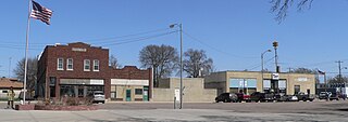
Duncan is a village in Platte County, Nebraska, United States. The population was 351 at the 2010 census.

Fultonville is a village in Montgomery County, New York, United States. The village is named after Robert Fulton, inventor of the steamboat.

<span class="mw-page-title-main">Manilla, New South Wales</span> Town in New South Wales, Australia

Manilla is a small town in New South Wales, Australia, located on Fossickers Way 45 kilometres northwest of the regional city of Tamworth and 27 kilometres northeast of the historic village Somerton. Manilla is famous for its setting as a fishing and paragliding area. The name Manilla comes from the Gamilaraay word 'Maneela', which is said to mean 'meeting of the rivers'.

<span class="mw-page-title-main">Warrawee, New South Wales</span> Suburb of Sydney, New South Wales, Australia

Warrawee is a suburb on the Upper North Shore of Sydney in the state of New South Wales, Australia. Warrawee is located 17 kilometres north-west of the Sydney Central Business District in the local government area of Ku-ring-gai Council. Warrawee is predominantly a small residential suburb with few commercial entities. Notably, its railway station provides no commercial activity which is uncommon in the Sydney train network.

<span class="mw-page-title-main">Tweed Heads, New South Wales</span> Town in New South Wales, Australia

Tweed Heads is a coastal town at the mouth of the Tweed River in the Northern Rivers region of the state of New South Wales, Australia. Tweed Heads is the northern most town in New South Wales, and is located in the Tweed Shire local government area. It is situated 830 km (520 mi) north of Sydney and 103 km (64 mi) south of Brisbane. The town is next to the border with Queensland and is adjacent to its "twin town" of Coolangatta, which is a suburb of the Gold Coast in Queensland.

<span class="mw-page-title-main">Murwillumbah</span> Town in New South Wales, Australia

Murwillumbah is a town in the Northern Rivers region of New South Wales, Australia, in the Tweed Shire, on the Tweed River. Sitting on the south eastern foothills of the McPherson Range in the Tweed Volcano valley, Murwillumbah is 848 km north-east of Sydney, 13 km south of the Queensland border and 132 km south of Brisbane.

<span class="mw-page-title-main">Coolangatta</span> Suburb of Gold Coast, Queensland, Australia

Coolangatta is a coastal suburb in the City of Gold Coast, Queensland, Australia. It is the Gold Coast's southernmost suburb and it borders New South Wales. In the 2016 census, Coolangatta had a population of 5,948 people.

<span class="mw-page-title-main">Uki, New South Wales</span> Village in New South Wales, Australia

Uki is a village situated near Mount Warning in the Tweed Valley of far northern New South Wales, Australia in the Tweed Shire. At the 2011 census, Uki had a population of 765 people. Its name may have come from an aboriginal word for "small water plant with a yellow flower and edible root".. The name UKI was actually derived from the limber mills in the area. Prime timber for export was marked UK 1, as in timber destined for the United Kingdom - grade 1. Hence UK1, which colloquially named the township UKI.

<span class="mw-page-title-main">West Pymble, New South Wales</span> Suburb of Sydney, New South Wales, Australia

West Pymble is a suburb on the Upper North Shore of Sydney in the state of New South Wales, Australia 15 kilometres (9.3 mi) north-west of the Sydney Central Business District in the local government area of Ku-ring-gai Council. Pymble is a separate suburb to the east, sharing the postcode of 2073.

<span class="mw-page-title-main">Wingham, New South Wales</span> Town in New South Wales, Australia

Wingham is a town in the Mid North Coast region of New South Wales, Australia in the Mid-Coast Council area 329 kilometres (204 mi) north of Sydney. According to the 2021 census, Wingham had a population of 5,395.

<span class="mw-page-title-main">Stratford, Victoria</span> Town in Victoria, Australia

Stratford is a town on the Avon River in Victoria, Australia, 232 kilometres (144 mi) east of Melbourne on the Princes Highway in Shire of Wellington. At the 2016 census, Stratford had a population of 2617. The town services the local regional community and travellers on the Princes Highway. Stratford's principal industries are dairying, sheep, cattle and horse breeding and vegetable crops. The town has numerous coffee shops and cafes, a cellar door for a local winery, Design Gallery, model railway shop, a pub, parks and playgrounds for car travelers to break their journey.

<span class="mw-page-title-main">Shire of Noosa</span> Local government area in Queensland, Australia

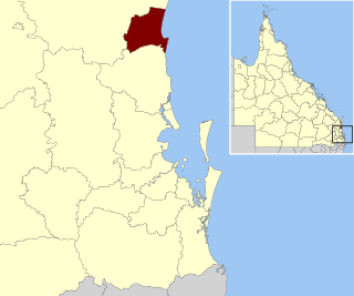
The Shire of Noosa is a local government area about 130 kilometres (81 mi) north of Brisbane in the Sunshine Coast district of South East Queensland, Australia. The shire covers an area of 870 square kilometres (335.9 sq mi). It existed as a local government entity from 1910 until 2008, when it was amalgamated with the Shire of Maroochy and City of Caloundra to form the Sunshine Coast Region. The shire was re-established on 1 January 2014. In the 2021 census, the shire had a population of 56,298 people.

<span class="mw-page-title-main">Tweed Shire</span> Local government area in New South Wales, Australia

Tweed Shire is a local government area located in the Northern Rivers region of New South Wales, Australia. It is adjacent to the border with Queensland, where that meets the Coral Sea. Administered from the town of Murwillumbah, Tweed Shire covers an area of 1,321 square kilometres (510 sq mi), and has existed as a local government entity since 1947. It was named for the Tweed River.

<span class="mw-page-title-main">Telegraph Point, New South Wales</span> Town in New South Wales, Australia

Telegraph Point is a small village on the North Coast of New South Wales, Australia. It is located on the Pacific Highway north of Port Macquarie, and on the North Coast railway line. The village spans both sides of the Wilson River.

<span class="mw-page-title-main">Bilpin, New South Wales</span> Suburb of City of Hawkesbury, New South Wales, Australia

Bilpin is a small town on the historic Bells Line of Road in the City of Hawkesbury local government area in the Blue Mountains, west of Sydney, New South Wales.

<span class="mw-page-title-main">Mount Mee, Queensland</span> Town in Queensland, Australia

Mount Mee is a rural town and locality in the City of Moreton Bay, Queensland, Australia. In the 2021 census, Mount Mee had a population of 519 people.

Tumbulgum is a village in northern New South Wales, Australia. It is in the Tweed Shire local government area, at the confluence of the Rous and Tweed Rivers, 818 kilometres (508 mi) north east of the state capital, Sydney and 120 kilometres (75 mi) south east of Brisbane. At the 2006 census, Tumbulgum had a population of 349.

Ruby Plains Station is a pastoral lease and cattle station located about 41 kilometres (25 mi) south of Halls Creek in the Kimberley region of Western Australia. It is situated along the Tanami Track and is used as a stopping place along the Canning Stock Route.

Wooyung is a small town located in the Northern Rivers Region of New South Wales. The most recent census indicated a population of 139, with a median age of 49. Wooyung means 'slow' in the local Bundjalung language, and is believed to reflect the natural tranquility of the area.

References

  1. "2016 Kunghur, Census All persons QuickStats | Australian Bureau of Statistics".
  2. "NSW Place and Road Naming Proposals System".
  3. Millar, Di (3 October 2010). "Place names attract intrigue". Daily Telegraph. Retrieved 27 November 2023.
  4. 1 2 3 4 Tweed Thematic History tweed.nsw.gov.au
  5. "District News". Tweed Daily. 26 May 1915.
  6. "District news". Tweed Daily. 4 March 1915. Retrieved 27 November 2023.
  7. "Kunghur". Tweed Daily. 16 May 1918.
  8. "Postal Improvements". Tweed Daily. 23 May 1917.
  9. "Kunghur School Sports". Tweed Daily. 7 July 1921.
  10. "Kunghur". Tweed Daily. 28 August 1922. Retrieved 27 November 2023.
  11. "World War II Experiences on the Home Front- Bushfires". 16 March 2020.
  12. "Cooloon Street, Kunghur Church - Former | Churches Australia".
  13. "District News". Tweed Daily. 2 April 1917.
  14. "Advertising". Tweed Daily. 2 April 1917.
  15. "Kunghur. Bachelor's Balls". Tweed Daily. 28 August 1923. Retrieved 27 November 2023.
  16. "Kunghur". Tweed Daily. 29 June 1923.
  17. "Tweed Rugby League". Northern Star. 22 June 1926.
  18. "Kunghur". Tweed Daily. 29 July 1922.
  19. "Kunghur". Tweed Daily. 29 June 1923.