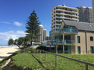
The Gold Coast, also known by its initials, GC, is a coastal city and region located approximately 66 kilometres (41 mi) south-southeast of the centre of the state capital, Brisbane. It is Queensland’s second-largest city after Brisbane, as well as Australia’s sixth-largest city and the most populous non-capital city, with a population over 600,000. The city’s central business district is located roughly in the centre of the Gold Coast in the suburb of Southport. The urban area of the Gold Coast is concentrated along the coast, sprawling almost 60 kilometres, joining up with the Greater Brisbane metropolitan region to the north and to the state border with New South Wales to the south. Nicknames of the city include the ‘Glitter Strip’ and the ‘Goldy’. The demonym of a Gold Coast resident is Gold Coaster.

Surfers Paradise is a town and suburb in the City of Gold Coast, Queensland, Australia. In the 2021 census, the suburb of Surfers Paradise had a population of 26,412 people.

Stradbroke Island, also known as Minjerribah, was a large sand island that formed much of the eastern side of Moreton Bay near Brisbane, Queensland until the late 19th century. Today the island is split into two islands: North Stradbroke Island and South Stradbroke Island, separated by the Jumpinpin Channel.

South Stradbroke Island, colloquially South Straddie, is an island that lies within Moreton Bay in the Australian state of Queensland, south of Brisbane and forms the northern end of Gold Coast. The island is a locality within the City of Gold Coast. In 2021 census, South Stradbroke Island had a population of 142 people.

Main Beach is a coastal town and suburb in the City of Gold Coast, Queensland, Australia. In the 2021 census, the suburb of Main Beach had a population of 3,998 people.

Southport is a coastal town and suburb in the City of Gold Coast in Queensland, Australia. It contains the Gold Coast central business district. In the 2021 census, Southport had a population of 36,786 people.

The Gold Coast Seaway or Southport Seaway is the main navigation entrance from the Pacific Ocean into the Gold Coast Broadwater and southern Moreton Bay and is one of Australia's most significant coastal engineering projects. It is located at the northern end of the Southport Spit where the Nerang River enters the Pacific Ocean. The channel was constructed between 1984 and 1986, primarily to facilitate the safe passage of sea-faring vessels. The passage was previously known as the Southport Bar. The mouth of the Nerang River was once located further south in Broadbeach. The main driving force for this movement is the northward drift of sand along the coast.

The Gold Coast Broadwater, also known as Southport Broadwater, Gold Coast Harbour and The Broadwater, is a large shallow estuary of water located in the Gold Coast district of South East Queensland, Australia. The estuary reaches from the locality of Southport in the south, to the southern section of the UNESCO World Heritage Listed Moreton Bay in the north. Separated via the Seaway from the Coral Sea by a thin strip of land called Stradbroke Island, the original body of water was a lagoon created from water deposited from the Nerang River. Part of the Broadwater is contained within the Moreton Bay Marine Park.
The Jumpinpin channel also known as The Pin lies between North Stradbroke Island and South Stradbroke Island. It has a fast moving tidal deep water channel not appropriate for swimming but is popular with beach anglers.

Point Lookout is a headland, small coastal town and locality on the eastern coast of North Stradbroke Island (Minjerribah), Redland City, Queensland, Australia.

Biggera Waters is a coastal suburb in the City of Gold Coast, Queensland, Australia. In the 2021 census, Biggera Waters had a population of 9,973 people.

Labrador is a coastal suburb in the City of Gold Coast, Queensland, Australia. In the 2021 census, Labrador had a population of 18,643 people.
The Gold Coast Shoreline Management Plan (GCSMP) is an ICZM plan to manage the coastal resources of City of Gold Coast. The EPA encourages the City Council's to produce shoreline management plans for coastlines and tidal waterways within the local authority area.
Narrow Neck is the name of an isthmus that separates the anabranch of the Nerang River from the Coral Sea in the City of Gold Coast, Queensland, Australia. It is also the boundary between the southern end of the suburb of Main Beach and the northern end of the suburb of Surfers Paradise.
Runaway Bay is a coastal suburb in the City of Gold Coast, Queensland, Australia. In the 2021 census, Runaway Bay had a population of 9,308 people.

South Passage is channel between the South Pacific Ocean and Moreton Bay. The other entrances to the bay are the North Passage or North Entrance and Jumpinpin Channel in the south.
Hollywell is a coastal suburb in the City of Gold Coast, Queensland, Australia. In the 2021 census, Hollywell had a population of 2,930 people.

Jacobs Well is a coastal suburb in the City of Gold Coast, Queensland, Australia. In the 2021 census, Jacobs Well had a population of 2,882 people.
Humphreys Boat Shed was a heritage-listed workshop and slipway at Seaworld Drive, Main Beach, Queensland, Australia. It was added to the Queensland Heritage Register on 31 August 2001, but was removed in June 2015 having been destroyed. However the remnants of the boat shed and slipway are listed on the Gold Coast Local Heritage Register.

The Chevron Island is an urban island that lies in the Nerang River and is a neighbourhood within the suburb of Surfers Paradise in the City of Gold Coast, Queensland, Australia.


