
The Town of Ithaca is a former local government area of Queensland, Australia, located in inner western Brisbane.
The Town of Ithaca is a former local government area of Queensland, Australia, located in inner western Brisbane.
The Ithaca Division was first proclaimed in 1879, and originally covered an area that stretched from Windsor, Kelvin Grove and Milton in the east, through to The Gap and beyond the Enoggera Dam in the west. In 1887 the division was split into the Shire of Windsor and the Enoggera Division, with the remainder in the south east becoming the Shire of Ithaca. Ithaca was proclaimed a town in 1903.

On 25 February 1922, Sir Matthew Nathan, the Governor of Queensland unveiled the Ithaca War Memorial to commemorate local people who had died in World War I. [1]
Ithaca was amalgamated into the newly created City of Brisbane in 1925.
The Town of Ithaca comprised most of the inner western suburbs of Brisbane from Kelvin Grove Road to the foot of Mount Coot-tha. Its boundary followed Enoggera Creek to the north, Coopers Camp, Simpsons and Boundary Roads in Bardon to the west, and Baroona and Milton Roads to the south. [2] Hale Street and an area just before the junction of Waterworks/Musgrave Road and Kelvin Grove Road formed the south-eastern extremity of the town. This eastern boundary was shared with the Brisbane Municipal Council; the Brisbane side of Hale Street was paved and channelled while the Ithaca side was not. [3]
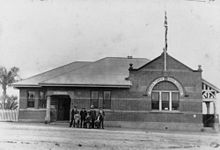
The Ithaca Town Council Chambers were built in 1910 at 99 Enoggera Terrace, in the then suburb of Ithaca (now in the suburb of Red Hill). With the amalgamation into City of Brisbane in 1925, the building became the property of the Brisbane City Council. Since then it has been used as a council depot, library and as the Red Hill Kindergarten. It is currently used as a community hall.
The Ithaca Town Council Chambers was listed on the Queensland Heritage Register in 2000. [4]
The Ithaca Embankments, a council urban beautification scheme, were listed on the Queensland Heritage Register in 1993. [5]

Alderley is a northern suburb in the City of Brisbane, Queensland, Australia. In the 2021 census, Alderley had a population of 6,748 people.

The Gap is a north-western suburb in the City of Brisbane, Queensland, Australia. In the 2021 census, The Gap had a population of 17,318 people.

Kelvin Grove is an inner northern suburb in the City of Brisbane, Queensland, Australia. In the 2021 census, Kelvin Grove had a population of 7,909 people.

Ashgrove is a suburb in the City of Brisbane, Queensland, Australia. In the 2021 census, Ashgrove had a population of 13,450 people.

Paddington is an inner suburb in the City of Brisbane, Queensland, Australia. In the 2021 census, Paddington had a population of 9,063 people.
Newmarket is a north-west suburb in the City of Brisbane, Queensland, Australia. In the 2021 census, Newmarket had a population of 5,083 people.

Red Hill is an inner northern suburb in the City of Brisbane, Queensland, Australia. In the 2021 census, Red Hill had a population of 5,834 people.

Enoggera is a north-western suburb in the City of Brisbane, Queensland, Australia. It is home to the Gallipoli Barracks.

St Johns Wood is a neighbourhood within the suburb of Ashgrove in the City of Brisbane, Queensland, Australia.

William Alfred Jolly CMG was an Australian politician who was the Mayor of the Town of Windsor from 1918 to 1923, the first Lord Mayor of Brisbane from 1925 to 1931, and a member of the Australian Parliament for the Division of Lilley from 1937 to 1943.
Ithaca is a former suburb of Brisbane, Australia. Since 1975, Ithaca has been designated a neighbourhood within the suburb of Red Hill in Brisbane.
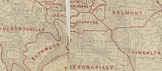
The Shire of Stephens was a local government area in the inner southern suburbs of Brisbane, Queensland, Australia. The shire, administered from Annerley, covered an area of 9 square miles (23 km2), and existed as a local government entity from 1886 until 1925, when it was amalgamated into the City of Brisbane under the City of Brisbane Act 1924.

The City of Brisbane is a local government area (LGA) which comprises the inner portion of Greater Brisbane, the capital of Queensland, Australia. Its governing body is the Brisbane City Council.
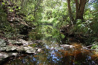
Ithaca Creek is a waterway in the Enoggera Creek catchment, in the western suburbs of Brisbane, Queensland, Australia. It arises in the Taylor Range at the Mount Coot-tha forest with two streams, one arising at J C Slaughter Falls, the other and stronger source being Simpson Falls, the western branch.
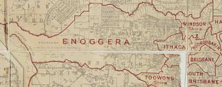
The Ithaca Division is a former local government area of Queensland, Australia, located in north-western Brisbane.

The Shire of Enoggera is a former local government area of Queensland, Australia, located in north-western Brisbane.

The Ithaca Town Council Chambers is a heritage-listed former town hall of the former local government area of the Town of Ithaca, and now a community centre in Paddington, City of Brisbane, Queensland, Australia. Located at 99 Enoggera Terrace, Red Hill, it was designed by Atkinson and McLay and built in 1910 by Charles Thomas Hall and Francis Joseph Mayer. It is also known as Ithaca Library and Red Hill Kindergarten. It was added to the Queensland Heritage Register on 24 March 2000.

Ithaca War Memorial and Park is a heritage-listed memorial and park at Enoggera Terrace, Paddington, Queensland, Australia. The memorial was designed and built by Arthur Henry Thurlow between 1921 and 1925. The park was built and designed by Alexander Jolly. It is also known as Alexander Jolly Park. It was added to the Queensland Heritage Register on 21 October 1992.
Arthur George Clarence Hawthorn was a solicitor, and member of both the Queensland Legislative Council and Queensland Legislative Assembly.

Waterworks Road is an 8.5 km (5.3 mi) arterial road in Brisbane, Queensland, Australia. It is currently signed as State Route 31 for its entire length. Waterworks Road transports traffic between the Brisbane central business district and western suburbs such as Red Hill, Ashgrove and The Gap.