
The Shire of Moggill is a former local government area of Queensland, Australia, located in western Brisbane.
The Shire of Moggill is a former local government area of Queensland, Australia, located in western Brisbane.
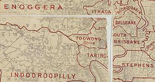
Toowong Division was one of the original divisions created on 11 November 1879 under the Divisional Boards Act of 1879. [1] On 20 May 1880, the more populated area of Toowong Division was proclaimed as the Shire of Toowong, with the remaining part of the Toowong Division being renamed Indooroopilly Division on 2 June 1880. [2] [3]
In 1890, residents in the Taringa area of the Indooroopilly Division began to agitate for the establishment of a separate division for Taringa. Their rationale was that the area around Taringa railway station had grown in population and was of a suburban character and that the interests of this community were different from those of the farming community that comprised the rest of Indooroopilly Division. [4] On 11 October 1890, Taringa Division was separated from Indooroopilly Division.
On 31 March 1903, the Local Authorities Act 1902 replaced Divisions with Shires and Towns, replacing Indooroopilly Division with Shire of Indooroopilly. [2] [5]
On 8 December 1917, the Shire of Indooroopilly was renamed Shire of Moggill. [5] [6]
On 1 October 1925, the shire was amalgamated into the City of Brisbane. [6]

Toowong is a riverside suburb in the City of Brisbane, Queensland, Australia. In the 2021 census, Toowong had a population of 12,556 people with a median weekly household income of $1,927.

Taringa is a suburb in the City of Brisbane, Queensland, Australia. In the 2021 census, Taringa had a population of 8,732 people.

Indooroopilly is a riverside suburb 7.8 kilometres (4.8 mi) south-west of the Brisbane CBD, Queensland, Australia. In the 2021 census, Indooroopilly had a population of 13,622 people.

The Western Freeway is a 5-kilometre-long (3.1 mi) freeway in western Brisbane that runs from Milton Road in Toowong to the western side of Indooroopilly where the freeway becomes the M5 Centenary Motorway. The freeway bears the symbol and forms part of Metroad 5. There is one interchange, at Indooroopilly onto Moggill Road. A bicycle path runs the length of the freeway, allowing commuting to Toowong and onto Brisbane by bicycle.
Moggill is a suburb in the City of Brisbane, Queensland, Australia. In the 2021 census, Moggill had a population of 5,029 people.

The Shire of Tiaro was a local government area in the Wide Bay–Burnett region of Queensland, Australia, between the regional cities of Gympie and Hervey Bay about 220 kilometres (137 mi) north of the state capital, Brisbane. The shire covered an area of 2,185.3 square kilometres (843.7 sq mi), and existed as a local government area from 1879 until 2008, when it was dissolved and split between two new local government areas, the Gympie Region and the Fraser Coast Region.

Moggill Road is a major road in Brisbane, Queensland, Australia. It commences at High Street at Toowong and terminates at the Moggill Ferry in Moggill. It is part of State Route 33. The road carried an average of 39,305 vehicles per day between July and December 2014.
The Shire of Yeerongpilly was a local government area in the southern suburbs of Brisbane, Queensland. The shire, administered from Rocklea, covered an area of 175 square miles (453 km2), and existed as a local government entity from 1879 until 1925, when it was split up following the creation of the City of Brisbane under the City of Brisbane Act 1924.
The Shire of Tingalpa was a local government area in the south-eastern suburbs of Brisbane, Queensland, Australia. The shire, administered from Mount Cotton, covered an area of 120 square miles (311 km2), and existed as a local government entity from 1879 until 1949.
The Town of Toowong is a former local government area of Queensland, Australia, located in western Brisbane in the area around the current suburb of Toowong.

The Shire of Coorparoo is a former local government area of Queensland, Australia, located in eastern Brisbane.

The Shire of Enoggera is a former local government area of Queensland, Australia, located in north-western Brisbane.

The Shire of Toombul was a local government area of Queensland, Australia, located in northern Brisbane from 1883 to 1925.

The Shire of Taringa is a former local government area of Queensland, Australia, located in western Brisbane. Its administrative centre was Taringa. It existed from 1890 to 1925.

The Shire of Nerang was a local government area in South East Queensland, Australia. The shire existed as a local government entity from 1879 until 1949.

The City of Gympie is a former local government area in the south-east of Queensland, Australia, responsible for governing Gympie.

The Shire of Walloon is a former local government area in the south-east of Queensland, Australia. Its administrative centre was in the town of Marburg.
The Shire of Purga is a former local government area in the south-east of Queensland, Australia.

The Shire of Mutdapilly is a former local government area in the south-east of Queensland, Australia. The name comes from the Mutdapilly locality, but the locality was never the administrative centre of the shire.
The Shire of Widgee is a former local government area in the Wide Bay–Burnett area of Queensland, Australia. It was located in the rural areas around the town of Gympie but did not include the town itself, which was always in a separate local government area. The administrative offices of the Shire of Widgee were located in Gympie.