
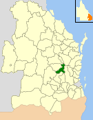
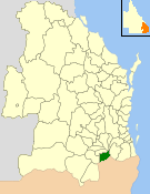
The Shire of Ravenswood was a local government area located in North Queensland, Australia. Its administrative centre was in Ravenswood.
The Shire of Ravenswood was a local government area located in North Queensland, Australia. Its administrative centre was in Ravenswood.
Ravenswood Division was created on 11 November 1879 as one of 74 divisions around Queensland under the Divisional Boards Act 1879 with a population of 1412. [1]
On 18 January 1882, the subdivisions were abolished (meaning all of board members would be elected by all residents rather than having representatives from different parts of the division). [2]
With the passage of the Local Authorities Act 1902, the Ravenswood Division became the Shire of Ravenswood on 31 March 1903.
However, with the decline in Ravenwood's population after World War I, it became increasingly financially unviable to have a separate local government authority. [3] On 1 January 1930, the Shire of Ravenswood was abolished and absorbed into the Shire of Dalrymple as its No. 3 division. [4] [5] [6]
On 15 March 2008, under the Local Government (Reform Implementation) Act 2007 passed by the Parliament of Queensland on 10 August 2007, the Shire of Dalrymple was amalgamated with the separate City of Charters Towers to form the Charters Towers Region. [7]

The Shire of Mareeba is a local government area at the base of Cape York Peninsula in Far North Queensland, inland from Cairns. The shire, administered from the town of Mareeba, covered an area of 53,491 square kilometres (20,653.0 sq mi), and existed as a local government entity from 1879 until 2008, when it amalgamated with several councils in the Atherton Tableland area to become the Tablelands Region.
The Shire of Nanango was a local government area located in the South Burnett region of Queensland, Australia, about 100 kilometres (62 mi) northwest of the capital, Brisbane. The Shire covered an area of 1,738.4 square kilometres (671.2 sq mi), and existed as a local government entity from 1879 until 2008, when it amalgamated with several other councils in the South Burnett area to become the South Burnett Regional Council.

The Shire of Booringa was a local government area in the Maranoa region of Queensland, Australia. The largest town and home of the shire administration was Mitchell. It existed from 1879 to 2008. The shire is now part of the Maranoa Region.
The Shire of Tambo was a local government area located in central Queensland south-east of the town of Blackall. It covered an area of 14,083.8 square kilometres (5,437.8 sq mi), and existed as a local government entity from 1881 until 2008, when it amalgamated with neighbouring Shire of Blackall to form the Blackall-Tambo Region.

The Shire of Blackall was a local government area located in central Queensland around the town of Blackall. It covered an area of 16,366.8 square kilometres (6,319.3 sq mi), and existed as a local government entity from 1879 until 2008, when it amalgamated with neighbouring Shire of Tambo to form the Blackall-Tambo Region.

The Shire of Cloncurry is a local government area in North West Queensland, Australia. It covers an area of 47,971 square kilometres (18,521.7 sq mi), and has existed as a local government entity since 1884. The major town and administrative centre of the shire is Cloncurry.

The Shire of Nebo was a local government area in Central Queensland, Queensland, Australia, about 80 kilometres (50 mi) south-west of the regional city of Mackay. The Shire, administered from the town of Nebo, covered an area of 10,034.6 square kilometres (3,874.4 sq mi), and existed as a local government entity from 1883 until 2008, when it was amalgamated with the Shires of Belyando and Broadsound to form the Isaac Region.

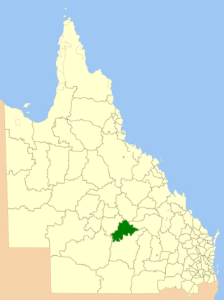
The Shire of Dalrymple was a local government area located in North Queensland, Australia, and surrounded but did not include the town of Charters Towers, at which its council and administrative centre was based. It covered an area of 68,324.5 square kilometres (26,380.2 sq mi), and existed as a local government entity from 1879 until 2008, when it amalgamated with the separate City of Charters Towers to form the Charters Towers Region.

The Shire of Tiaro was a local government area in the Wide Bay–Burnett region of Queensland, Australia, between the regional cities of Gympie and Hervey Bay about 220 kilometres (137 mi) north of the state capital, Brisbane. The shire covered an area of 2,185.3 square kilometres (843.7 sq mi), and existed as a local government area from 1879 until 2008, when it was dissolved and split between two new local government areas, the Gympie Region and the Fraser Coast Region.

The Shire of Inglewood was a local government area of Queensland, Australia on the Queensland-New South Wales border in the Darling Downs region, about halfway between the towns of Goondiwindi and Warwick. Administered from the town of Inglewood, it covered an area of 5,876.7 square kilometres (2,269.0 sq mi), and existed as a local government entity from 1879 until 2008, when it amalgamated with the Shire of Waggamba and the Town of Goondiwindi to form the Goondiwindi Region.

The Shire of Cardwell was a local government area of Queensland. It was located on the Coral Sea coast about halfway between the cities of Cairns and Townsville. The shire, administered from the town of Tully, covered an area of 3,062.2 square kilometres (1,182.3 sq mi), and existed as a local government entity from 1884 until 2008, when it amalgamated with the Shire of Johnstone to form the Cassowary Coast Region.

The Charters Towers Region is a local government area in North Queensland, Australia southwest of, and inland from the city of Townsville, based in Charters Towers. Established in 2008, it was preceded by two previous local government areas which dated back to the 1870s.

Ravenswood is a rural town and locality in the Charters Towers Region, Queensland, Australia. In the 2021 census, the locality of Ravenswood had a population of 297 people.
The Shire of Glengallan was a local government area south and east of the regional centre of Warwick in the Darling Downs region of Queensland. The shire, administered from Warwick, covered an area of 1,699.6 square kilometres (656.2 sq mi), and existed as a local government entity from 1879 until 1994, when it was dissolved and amalgamated with City of Warwick, Shire of Rosenthal and Shire of Allora to form the Shire of Warwick.

The Shire of Rosenthal was a local government area south and west of the regional centre of Warwick in the Darling Downs region of Queensland. The shire, administered from Rosenthal Heights, a Warwick suburb, covered an area of 1,984.1 square kilometres (766.1 sq mi), and existed as a local government entity from 1886 until 1994, when it was dissolved and amalgamated with City of Warwick, Shire of Allora and Shire of Glengallan to form the Shire of Warwick.

The Shire of Adavale is a former local government area in the south-east of Queensland, Australia, centred on the town of Adavale. It existed from 1879 to 1930.

The Shire of Nerang was a local government area in South East Queensland, Australia. The shire existed as a local government entity from 1879 until 1949.

The City of Gympie is a former local government area in the south-east of Queensland, Australia, responsible for governing Gympie.
The Shire of Walsh was a local government area in Far North Queensland, Australia, located to the south-west of the town Cairns.
The Shire of Queenton was a local government area located in North Queensland, Australia. It was located to the south of Charters Towers and existed from 1902 to 1916.