
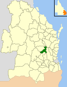
The City of Gympie is a former local government area in the south-east of Queensland, Australia, responsible for governing Gympie.
The City of Gympie is a former local government area in the south-east of Queensland, Australia, responsible for governing Gympie.
On 11 November 1879, the Gympie Division was created as one of 74 divisions within Queensland under the Divisional Boards Act 1879 with a population of 4338. [1]
However, the residents felt that Gympie warranted a municipality and petitioned the Queensland Government. [2] On 25 June 1880, the division was abolished in favour of a municipality, the Borough of Gympie which held its first elections on 25 August 1880. [3]
A town hall was built in 1890.
On 4 January 1895, Glastonbury Division was abolished and split between the Widgee Division and the Borough of Gympie. [4] [5]
On 31 March 1903 the Borough of Gympie became the Town of Gympie under the Local Authorities Act 1902 and on 7 January 1905 was proclaimed City of Gympie by the Governor of Queensland. [6] [7]
On 19 March 1992, the Electoral and Administrative Review Commission, created two years earlier, produced its report External Boundaries of Local Authorities, and recommended that the City of Gympie and the Shire of Widgee should be amalgamated. [8] The recommendation was implemented through the Local Government (Shire of Cooloola) Regulation 1993 creating the new Shire of Cooloola on 2 November 1993. [9] The first elections were held on 27 November 1993 and Adrian McClintock, the former Widgee chairman, was elected for a four-year term.
On 15 March 2008, under the Local Government (Reform Implementation) Act 2007 passed by the Parliament of Queensland on 10 August 2007, the Shire of Cooloola merged with the Shire of Kilkivan and Division 3 (Theebine/Gunalda areas) of Shire of Tiaro to form the Gympie Region. [10]
The following are the chairmen of Gympie Division:
The following are the mayors of Gympie Borough/Town/City: [12]
The Shire of Nanango was a local government area located in the South Burnett region of Queensland, Australia, about 100 kilometres (62 mi) northwest of the capital, Brisbane. The Shire covered an area of 1,738.4 square kilometres (671.2 sq mi), and existed as a local government entity from 1879 until 2008, when it amalgamated with several other councils in the South Burnett area to become the South Burnett Regional Council.

The Shire of Kilkivan was a local government area about 180 kilometres (112 mi) north-northwest of Brisbane, the state capital of Queensland, Australia. The shire covered an area of 3,263.4 square kilometres (1,260.0 sq mi), and existed from 1886 until its merger with several other local government areas to form the Gympie Region on 15 March 2008.

The Shire of Waggamba was a local government area of Queensland, Australia on the Queensland-New South Wales border in the Darling Downs region, surrounding the Town of Goondiwindi, a separate local government area limited to the town. Administered from the town of Goondiwindi, it covered an area of 13,400.8 square kilometres (5,174.1 sq mi), and existed as a local government entity from 1879 until 2008, when it amalgamated with the Shire of Inglewood and the Town of Goondiwindi to form the Goondiwindi Region.

The Shire of Murweh is a local government area in the Maranoa district, which is part of South West Queensland, Australia. The administrative centre and largest town in the shire is Charleville. In June 2018, the Shire of Murweh had a population of 4,318.

The Shire of Tiaro was a local government area in the Wide Bay–Burnett region of Queensland, Australia, between the regional cities of Gympie and Hervey Bay about 220 kilometres (137 mi) north of the state capital, Brisbane. The shire covered an area of 2,185.3 square kilometres (843.7 sq mi), and existed as a local government area from 1879 until 2008, when it was dissolved and split between two new local government areas, the Gympie Region and the Fraser Coast Region.
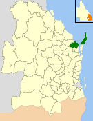
The Shire of Cooloola was a local government area located about 170 kilometres (106 mi) north of Brisbane – the state capital of Queensland, Australia. The shire covered an area of 2,968.8 square kilometres (1,146.3 sq mi), and was the product of a merger in 1993 between the City of Gympie and the Shire of Widgee, which had both existed since 1879-1880. It merged with several other LGAs to form the Gympie Region on 15 March 2008.

The City of Maryborough was a local government area located in the Wide Bay–Burnett region of Queensland, Australia, containing the urban locality of Maryborough as well as the southern half of Fraser Island. The City covered an area of 1,233.9 square kilometres (476.4 sq mi), and existed as a local government entity from 1861 until 2008, when it was amalgamated with the City of Hervey Bay, Shire of Woocoo and the 1st and 2nd divisions of the Shire of Tiaro to form the Fraser Coast Region.
The City of Hervey Bay was a local government area located in the Wide Bay–Burnett region of Queensland, Australia, containing the urban centre of Hervey Bay as well as the northern half of Fraser Island. The City covered an area of 2,356.3 square kilometres (909.8 sq mi), and existed as a local government entity in various forms from 1879 until 2008, when it was amalgamated with the City of Maryborough, Shire of Woocoo and the 1st and 2nd divisions of the Shire of Tiaro to form the Fraser Coast Region.

The City of Rockhampton was a local government area in the Central Queensland region of Queensland, Australia, encompassing most of the suburban area of the regional city of Rockhampton. The city covered an area of 188.7 square kilometres (72.9 sq mi), and existed as a local government entity in various forms from 1860 until 2008, when it amalgamated with several other councils in the surrounding area to become the Rockhampton Region.

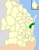
The Gympie Region is a local government area in the Wide Bay–Burnett region of Queensland, Australia, about 170 kilometres (110 mi) north of Brisbane, the state capital. It is between the Sunshine Coast and Hervey Bay and centred on the town of Gympie. It was created in 2008 from a merger of the Shires of Cooloola and Kilkivan and part of the Shire of Tiaro.
Monkland is a locality in the Gympie Region, Queensland, Australia.
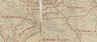
The Shire of Stephens was a local government area in the inner southern suburbs of Brisbane, Queensland, Australia. The shire, administered from Annerley, covered an area of 9 square miles (23 km2), and existed as a local government entity from 1886 until 1925, when it was amalgamated into the City of Brisbane under the City of Brisbane Act 1924.
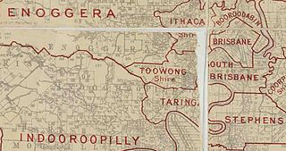
The Town of Toowong is a former local government area of Queensland, Australia, located in western Brisbane in the area around the current suburb of Toowong.

The Shire of Enoggera is a former local government area of Queensland, Australia, located in north-western Brisbane.

The Shire of Toombul was a local government area of Queensland, Australia, located in northern Brisbane from 1883 to 1925.
The Shire of Widgee is a former local government area in the Wide Bay–Burnett area of Queensland, Australia. It was located in the rural areas around the town of Gympie but did not include the town itself, which was always in a separate local government area. The administrative offices of the Shire of Widgee were located in Gympie.
The Glastonbury Division is a former local government area in the Wide Bay–Burnett area of Queensland, Australia. Its headquarters were located in the town of Gympie.
The Town of Blackall was a local government area located in central Queensland, for the purposes of governing the town of Blackall. It exists from 1880 to 1931.

The Bank of New South Wales is a heritage-listed former bank at 242 Mary Street, Gympie, Gympie Region, Queensland, Australia. It was designed by Richard Gailey and built from 1890 to 1891 by T. Kelly. It is also known as Widgee Shire Council Chambers, Coolooa Shire Council Chambers and Gympie Regional Council Chambers. It was added to the Queensland Heritage Register on 15 April 2011.

Bells Bridge is a locality in the Gympie Region, Queensland, Australia.