
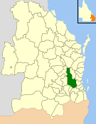
The Ballandean Division was a local government area on the Granite Belt, Queensland, Australia, close to the Queensland-New South Wales border. It only existed between 1879 and 1880.
The Ballandean Division was a local government area on the Granite Belt, Queensland, Australia, close to the Queensland-New South Wales border. It only existed between 1879 and 1880.
Ballandean Division was one of the original divisions created by the Divisional Boards Act 1879 with a population of 2430. [1]
On 25 June 1880, Ballanean Division was abolished and was absorbed into its northern neighbour Stanthorpe Division. [2]

The Shire of Perry was a local government area in the northern catchment of the Burnett River, Queensland, Australia. The Shire covered an area of 2,357.7 square kilometres (910.3 sq mi), and existed as a local government area from 1880 until 2008, when it amalgamated with several other shires to form the North Burnett Region.

The Shire of Bungil was a local government area in the Maranoa region of Queensland, Australia. It existed from 1880 to 2008.

The Shire of Booringa was a local government area in the Maranoa region of Queensland, Australia. The largest town and home of the shire administration was Mitchell. It existed from 1879 to 2008. The shire is now part of the Maranoa Region.

The Shire of Bulloo is a local government area in South West Queensland, Australia.
The Shire of Esk was a local government area in South East Queensland, Australia, located about 90 kilometres (56 mi) west - northwest of Brisbane. It stretched from the Lockyer Valley north and west to the Great Dividing Range and up the valley of the Brisbane River. Esk covered an area of 3,936.2 square kilometres (1,519.8 sq mi), and existed from 1879 until its merger with the Shire of Kilcoy to form the Somerset Region on 15 March 2008.
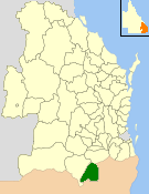
The Shire of Stanthorpe was a local government area of Queensland, Australia on the Queensland-New South Wales border. It was on the Great Dividing Range and was part of the Granite Belt. Its main industries included fruit and vegetable growing, wineries and tourism, and sheep and cattle grazing.

The Shire of Hinchinbrook is a local government area in North Queensland, Queensland, Australia. The shire, administered from the town of Ingham, covers an area of 2,807 square kilometres (1,083.8 sq mi), and has existed since its creation on 11 November 1879 as one of 74 divisions around Queensland under the Divisional Boards Act 1879.
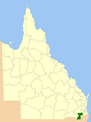
The Southern Downs Region is a local government area (LGA) in the Darling Downs region of Queensland, Australia. The region runs along the state's southern boundary with New South Wales and was created in 2008 from a merger of the Shire of Warwick and the Shire of Stanthorpe.

The Shire of Mulgrave was a local government area surrounding the City of Cairns in the Far North region of Queensland. The shire, administered from Cairns, covered an area of 1,718.3 square kilometres (663.4 sq mi); it existed as a local government entity from 1879 until 1995, when it was dissolved and amalgamated into the City of Cairns.
The Shire of Tingalpa was a local government area in the south-eastern suburbs of Brisbane, Queensland, Australia. The shire, administered from Mount Cotton, covered an area of 120 square miles (311 km2), and existed as a local government entity from 1879 until 1949.

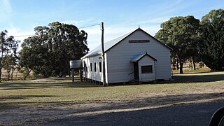
Ballandean is a rural town and locality in the Southern Downs Region, Queensland, Australia. The town has a number of nearby vineyards which attracted tourists to the area. In the 2021 census, the locality of Ballandean had a population of 316 people.
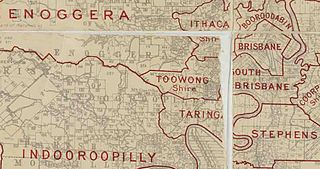
The Town of Toowong is a former local government area of Queensland, Australia, located in western Brisbane in the area around the current suburb of Toowong.

The Shire of Moggill is a former local government area of Queensland, Australia, located in western Brisbane.

The Shire of Taringa is a former local government area of Queensland, Australia, located in western Brisbane. Its administrative centre was Taringa. It existed from 1890 to 1925.

The Shire of Nerang was a local government area in South East Queensland, Australia. The shire existed as a local government entity from 1879 until 1949.

The Shire of Tinana is a former local government area in the Wide Bay–Burnett area of Queensland, Australia. It is centred on Tinana, on the southern bank of the Mary River, with the Borough of Maryborough on the northern bank. It existed from 1880 to 1917.
Eukey is a rural locality in the Southern Downs Region, Queensland, Australia. It is on the border with New South Wales. In the 2021 census, Eukey had a population of 140 people.
Fletcher is a rural locality in the Southern Downs Region, Queensland, Australia. In the 2021 census, Fletcher had a population of 128 people.
Nundubbermere is a rural locality in the Southern Downs Region, Queensland, Australia. In the 2021 census, Nundubbermere had a population of 102 people.