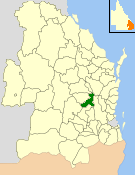
The Shire of Nanango was a local government area located in the South Burnett region of Queensland, Australia, about 100 kilometres (62 mi) northwest of the capital, Brisbane. The Shire covered an area of 1,738.4 square kilometres (671.2 sq mi), and existed as a local government entity from 1879 until 2008, when it amalgamated with several other councils in the South Burnett area to become the South Burnett Regional Council.

The Shire of Kilkivan was a local government area about 180 kilometres (112 mi) north-northwest of Brisbane, the state capital of Queensland, Australia. The shire covered an area of 3,263.4 square kilometres (1,260.0 sq mi), and existed from 1886 until its merger with several other local government areas to form the Gympie Region on 15 March 2008.

The Shire of Duaringa was a local government area in the Capricornia region of Queensland, Australia. Duaringa Shire covered an area of 18,201 square kilometres and had a population of 6,744 according to the 2006 census. On 15 March 2008 the shires of Duaringa, Emerald, Bauhinia and Peak Downs were amalgamated to form the Central Highlands Region.

The Shire of Tambo was a local government area located in central Queensland south-east of the town of Blackall. It covered an area of 14,083.8 square kilometres (5,437.8 sq mi), and existed as a local government entity from 1881 until 2008, when it amalgamated with neighbouring Shire of Blackall to form the Blackall-Tambo Region.

The Shire of Cloncurry is a local government area in North West Queensland, Australia. It covers an area of 47,971 square kilometres (18,521.7 sq mi), and has existed as a local government entity since 1884. The major town and administrative centre of the shire is Cloncurry.
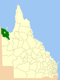
The Shire of Carpentaria is a local government area in Far North Queensland, Australia on the Gulf of Carpentaria, for which it is named.
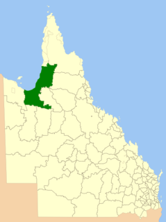
The Shire of Burke is a local government area in North West Queensland, Australia. The shire lies on the south coast of the Gulf of Carpentaria and abuts the border with the Northern Territory. It covers an area of 39,864 square kilometres (15,391.6 sq mi), and has existed as a local government entity since 1885. The major town and administrative centre of the shire is Burketown.

The Shire of Tiaro was a local government area in the Wide Bay–Burnett region of Queensland, Australia, between the regional cities of Gympie and Hervey Bay about 220 kilometres (137 mi) north of the state capital, Brisbane. The shire covered an area of 2,185.3 square kilometres (843.7 sq mi), and existed as a local government area from 1879 until 2008, when it was dissolved and split between two new local government areas, the Gympie Region and the Fraser Coast Region.

The Shire of Hinchinbrook is a local government area in North Queensland, Queensland, Australia. The shire, administered from the town of Ingham, covers an area of 2,807 square kilometres (1,083.8 sq mi), and has existed since its creation on 11 November 1879 as one of 74 divisions around Queensland under the Divisional Boards Act 1879.
The Shire of Woongarra was a local government area located to the south and east of the regional city of Bundaberg. The shire, administered from Bundaberg itself, covered an area of 722.4 square kilometres (278.9 sq mi), and existed as a local government entity from 1885 until 1994, when it amalgamated with Gooburrum to form the Shire of Burnett.

The Shire of Mulgrave was a local government area surrounding the City of Cairns in the Far North region of Queensland. The shire, administered from Cairns, covered an area of 1,718.3 square kilometres (663.4 sq mi); it existed as a local government entity from 1879 until 1995, when it was dissolved and amalgamated into the City of Cairns.

The Town of Wynnum is a former local government area of Queensland, Australia, located in eastern Brisbane adjacent to Moreton Bay around the present day suburb of Wynnum.

The Kedron Division is a former local government area of Queensland, Australia, located in northern Brisbane.

The Shire of Coomera was a local government area in South East Queensland, Australia. The shire, administered from Coomera, existed as a local government entity from 1879 until 1949.

The Shire of Nerang was a local government area in South East Queensland, Australia. The shire existed as a local government entity from 1879 until 1949.

The Shire of Tinana is a former local government area in the Wide Bay–Burnett area of Queensland, Australia. It is centred on Tinana, on the southern bank of the Mary River, with the Borough of Maryborough on the northern bank. It existed from 1880 to 1917.

The Shire of Granville is a former local government area in the Wide Bay–Burnett area of Queensland, Australia.

The Shire of Hann is a former local government area in Far North Queensland, Australia.

The Shire of Barolin was a local government area located in the Wide Bay–Burnett region of Queensland, Australia. It was the area south of the Burnett River but excluding the urban area of Bundaberg which was initially in Bundaberg Division. It existed from 1879 to 1917.
The Shire of Widgee is a former local government area in the Wide Bay–Burnett area of Queensland, Australia. It was located in the rural areas around the town of Gympie but did not include the town itself, which was always in a separate local government area. The administrative offices of the Shire of Widgee were located in Gympie.
