
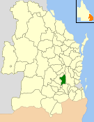
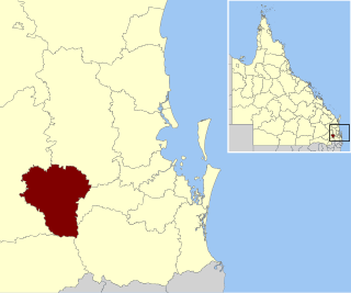
The Shire of Highfields is a former local government area on the Darling Downs in Queensland, Australia. It existed between 1879 and 1949.
The Shire of Highfields is a former local government area on the Darling Downs in Queensland, Australia. It existed between 1879 and 1949.
On 11 November 1879, the Highfields Division was created as one of 74 divisions within Queensland under the Divisional Boards Act 1879 with a population of 1998. [1] [2] It was divided into three sub-divisions with estimated populations of 480, 891 and 627 for Sub-divisions 1, 2 and 3 respectively, a total of 1989. [3]
On 18 January 1884, there was an adjustment of boundaries between Highfields Division's subdivisions Nos. 1 and 2 and Esk Division. [4] [5]
In 1886, the Highfields Division was extended to incorporate the areas of Perseverance, Ravensbourne, Crows Nest, Djuan, Emu Creek, and Cooyar. [3]
With the passage of the Local Authorities Act 1902, the Highfields Division became the Shire of Highfields on 31 March 1903.
In 1910–11, there was considerable pressure to persuade the shire council to relocate their office from Cabarlah to Crows Nest., [6] [7] [8] but the shire council did not wish to put the issue to a referendum. [9] This led to further agitation to create a new shire with Crows Nest at its centre. [10]
On 25 January 1913, part of the Shire of Highfields was excised to create the Shire of Crows Nest. [11]
On 19 March 1949, the Shire of Highfields was abolished and split between the Shire of Crows Nest and the Shire of Gatton. [2] [12] [13] [14]
The following men were the chairmen of the Highfields Divisional Board and the Highfields Shire Council. [3]
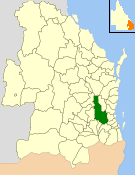
The Shire of Crows Nest was a local government area in the Darling Downs region of Queensland, Australia, immediately northeast of the regional city of Toowoomba. The shire, administered from the town of Crows Nest, covered an area of 1,629.9 square kilometres (629.3 sq mi), and existed as a local government entity from 1913 until 2008, when it amalgamated with several other councils in the Toowoomba area to form the Toowoomba Region. Its growth in later years has been fuelled by the expansion of Toowoomba, particularly the suburbs of Highfields and Blue Mountain Heights which, with a combined population of 7,333 in 2006, were home to over half the shire's population.

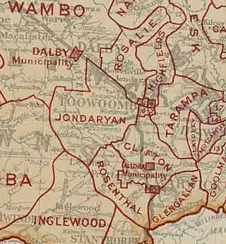
The Shire of Jondaryan was a local government area located in the Darling Downs region of Queensland, Australia, immediately west of the regional city of Toowoomba. The shire, administered from the town of Oakey, covered an area of 1,910.0 square kilometres (737.5 sq mi), and existed as a local government entity from 1890 until 2008, when it amalgamated with several other councils in the Toowoomba area to form the Toowoomba Region. Its growth in later years has been fuelled by the expansion of Toowoomba and suburbs such as Glenvale and Westbrook.

The Shire of Rosalie was a local government area in the Darling Downs region of Queensland, Australia, immediately northwest of the regional city of Toowoomba. The shire, administered from the town of Goombungee, covered an area of 2,200.7 square kilometres (849.7 sq mi), and existed as a local government entity from 1879 until 2008. In 2008, it amalgamated with several other councils in the Toowoomba area to form the Toowoomba Region.

The City of Toowoomba was a local government area in the Darling Downs region of Queensland, Australia, encompassing the centre and inner suburbs of the regional city of Toowoomba. The City covered an area of 116.5 square kilometres (45.0 sq mi), and existed as a local government entity in various forms from 1860 until 2008, when it amalgamated with several other councils in the surrounding area to form the Toowoomba Region.

The Shire of Waggamba was a local government area of Queensland, Australia on the Queensland-New South Wales border in the Darling Downs region, surrounding the Town of Goondiwindi, a separate local government area limited to the town. Administered from the town of Goondiwindi, it covered an area of 13,400.8 square kilometres (5,174.1 sq mi), and existed as a local government entity from 1879 until 2008, when it amalgamated with the Shire of Inglewood and the Town of Goondiwindi to form the Goondiwindi Region.
The Shire of Esk was a local government area in South East Queensland, Australia, located about 90 kilometres (56 mi) west - northwest of Brisbane. It stretched from the Lockyer Valley north and west to the Great Dividing Range and up the valley of the Brisbane River. Esk covered an area of 3,936.2 square kilometres (1,519.8 sq mi), and existed from 1879 until its merger with the Shire of Kilcoy to form the Somerset Region on 15 March 2008.
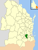
The Shire of Gatton was a local government area located in the Lockyer Valley region between the cities of Toowoomba and Ipswich, and about 90 kilometres (56 mi) west of Brisbane, the state capital of Queensland, Australia. The shire covered an area of 1,571.8 square kilometres (606.9 sq mi), and existed from 1880 until its merger with the Shire of Laidley to form the Lockyer Valley Region on 15 March 2008.
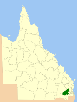
The Toowoomba Region is a local government area (LGA) located within the larger Darling Downs region of Queensland, Australia. Established in 2008, the LGA was preceded by several other local government authorities with histories extending back to the early 1900s and beyond.
The Lockyer Valley Region is a local government area (LGA) in the West Moreton region of South East Queensland, Australia. The region is located between the cities of Ipswich and Toowoomba, and is bordered by the Somerset and Southern Downs regions to the north and south, respectively. Lockyer Valley was created in 2008 from a merger of the former shires of Gatton and Laidley. The Lockyer Valley Regional Council has an estimated operating budget of A$35m.

Crows Nest is a rural town and locality in the Toowoomba Region, Queensland, Australia. The town is located in the Darling Downs on the New England Highway, 158 kilometres (98 mi) from the state capital, Brisbane and 43 kilometres (27 mi) from the nearby city of Toowoomba. In the 2021 census, the locality of Crows Nest had a population of 2,212 people.
The Shire of Moreton was a local government area in South East Queensland, Australia, located about 50 kilometres (31 mi) southwest of Queensland's capital, Brisbane. It represented an area surrounding but not including Ipswich, and existed from 1917 until 1995, when it merged into the City of Ipswich, City of Brisbane, and Shire of Esk.
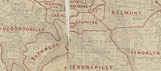
The Shire of Stephens was a local government area in the inner southern suburbs of Brisbane, Queensland, Australia. The shire, administered from Annerley, covered an area of 9 square miles (23 km2), and existed as a local government entity from 1886 until 1925, when it was amalgamated into the City of Brisbane under the City of Brisbane Act 1924.
The Shire of Tingalpa was a local government area in the south-eastern suburbs of Brisbane, Queensland, Australia. The shire, administered from Mount Cotton, covered an area of 120 square miles (311 km2), and existed as a local government entity from 1879 until 1949.

The Shire of Coomera was a local government area in South East Queensland, Australia. The shire, administered from Coomera, existed as a local government entity from 1879 until 1949.

The Shire of Nerang was a local government area in South East Queensland, Australia. The shire existed as a local government entity from 1879 until 1949.
The Shire of Drayton was a local government area in the Darling Downs region of Queensland, Australia, west of Toowoomba. It existed between 1887 and 1949.

The Shire of Walloon is a former local government area in the south-east of Queensland, Australia. Its administrative centre was in the town of Marburg.
The Shire of Purga is a former local government area in the south-east of Queensland, Australia.

Ravensbourne is a rural locality in the Toowoomba Region, Queensland, Australia. In the 2021 census, Ravensbourne had a population of 307 people.

Perseverance is a rural locality in the Toowoomba Region, Queensland, Australia. In the 2021 census, Perseverance had a population of 72 people.