The Shire of Purga is a former local government area in the south-east of Queensland, Australia.
The Shire of Purga is a former local government area in the south-east of Queensland, Australia.
On 11 November 1879, the Purga Division was created as one of 74 divisions within Queensland under the Divisional Boards Act 1879 with a population of 2089. [1] [2]
With the passage of the Local Authorities Act 1902, the Purga Division became the Shire of Purga on 31 March 1903. [2] [3]
On 13 October 1916, a rationalisation of the local government areas in and around Ipswich was implemented. It involved the abolition of five shires: [4]
resulting in:

The Shire of Tiaro was a local government area in the Wide Bay–Burnett region of Queensland, Australia, between the regional cities of Gympie and Hervey Bay about 220 kilometres (137 mi) north of the state capital, Brisbane. The shire covered an area of 2,185.3 square kilometres (843.7 sq mi), and existed as a local government area from 1879 until 2008, when it was dissolved and split between two new local government areas, the Gympie Region and the Fraser Coast Region.

The Shire of Boonah was a local government area in South East Queensland, Australia, about 80 kilometres (50 mi) southwest of Brisbane. The shire covered an area of 1,921.6 square kilometres (741.9 sq mi), and existed from 1880 until its merger with parts of the Shire of Beaudesert and City of Ipswich to form the Scenic Rim Region on 15 March 2008.

The City of Ipswich is a local government area in Queensland, Australia, located in the southwest of the Brisbane metropolitan area, including the urban area surrounding the city of Ipswich and surrounding rural areas.
The Shire of Moreton was a local government area in South East Queensland, Australia, located about 50 kilometres (31 mi) southwest of Queensland's capital, Brisbane. It represented an area surrounding but not including Ipswich, and existed from 1917 until 1995, when it merged into the City of Ipswich, City of Brisbane, and Shire of Esk.
The Shire of Beenleigh is a former local government area in the south-east of Queensland, Australia, centred on the town of Beenleigh. It existed from 1879 to 1949.

The Shire of Cleveland is a former local government area in the south-east of Queensland, Australia, centred on the town of Cleveland beside Moreton Bay.
The Shire of Waterford is a former local government area in the south-east of Queensland, Australia, centred on the town of Waterford. It existed between 1879 and 1948.

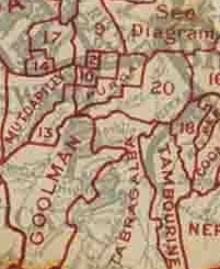
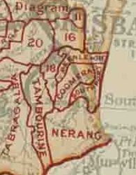
The Shire of Nerang was a local government area in South East Queensland, Australia. The shire existed as a local government entity from 1879 until 1949.
The Shire of Tamborine was a local government area in South East Queensland, Australia, centred on the village of Tamborine. It existed from 1890 to 1949.

The Town of Southport was a local government area in South East Queensland, Australia.
The Town of Coolangatta was a local government area in South East Queensland, Australia, centred on Coolangatta. It existed from 1914 to 1949.
The Town of South Coast was a local government area in South East Queensland, Australia.

The Shire of Brassall is a former local government area in the south-east of Queensland, Australia. It existed from 1879 to 1917.
The Shire of Bundanba is a former local government area in the south-east of Queensland, Australia. It existed from 1879 to 1916.

The Shire of Walloon is a former local government area in the south-east of Queensland, Australia. Its administrative centre was in the town of Marburg.

The Shire of Rosewood is a former local government area in the south-east of Queensland, Australia.
The Shire of Lowood is a former local government area in the south-east of Queensland, Australia. It existed between 1912 and 1916.
The Shire of Ipswich is a former local government area in the south-east of Queensland, Australia.

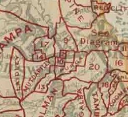
The Shire of Mutdapilly is a former local government area in the south-east of Queensland, Australia. The name comes from the Mutdapilly locality, but the locality was never the administrative centre of the shire.

The Shire of Normanby is a former local government area in the south-east of Queensland, Australia. Its administrative centre was in Harrisville.