
The Shire of Mutdapilly is a former local government area in the south-east of Queensland, Australia. The name comes from the Mutdapilly locality, but the locality was never the administrative centre of the shire.
The Shire of Mutdapilly is a former local government area in the south-east of Queensland, Australia. The name comes from the Mutdapilly locality, but the locality was never the administrative centre of the shire.
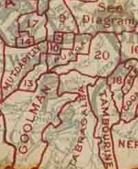
On 11 November 1879, the Mutdapilly Division was created as one of 74 divisions within Queensland under the Divisional Boards Act 1879 with a population of 1809. [1] [2] Initially the divisional office was in the Ipswich Railway Station (outside of the division itself). [3]
On 4 January 1884, there was an adjustment of boundaries between No. 2 subdivision of Mutdapilly Division and subdivision No. 2 of the Goolman Division. [4] [5]
Having an office in Ipswich (outside of the division) was not very convenient for many council members, ratepayers, and contractors, particularly those living in the southern parts of the division, such as Rosevale. The possibility of relocating the divisional offices to somewhere more central within the division was frequently raised. In March 1890, it was decided to relocate the office to Mount Walker. This would put everyone within 9 miles of the office, instead of some people having to travel up to 29 miles to Ipswich. [6] [7] However, the decision was controversial with many ratepayers arguing that they had to travel to Ipswich to transact other business, but not to Mount Walker, so Ipswich was actually more convenient for them. It was also argued that the difficulties of those in the Rosevale area were over-stated as there were a disproportionate number of members of the divisional board living in that area. [8] In June 1890, the divisional board voted to rescind the decision to relocate their office to Mount Walker. [9]
On 25 October 1890, part of the Mutdapilly Division was excised to create the Normanby Division. [10]
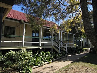
The separation of the Normanby Division and the resultant change to the composition of the Mutdapilly Division Board lead to the decision in February 1891 to proceed with the Mount Walker office. [11] Divisional board meetings were immediately relocated to Mount Walker albeit in temporary premises, [12] and in April 1891 a piece of land was purchased in Mount Walker and tenders called for the construction of the office. [13] The office was finished and in use by July 1891. [14]
With the passage of the Local Authorities Act 1902, the Mutdapilly Division became the Shire of Mutdapilly on 31 March 1903. [2] [15]
In September 1904, the shire council voted to relocate their office from Mount Walker to Rosewood (not within the shire). The disadvantages of Mount Walker included lack of railway facilities, lack of banking facilities and poor postal facilities, all of which were available in Rosewood. [16] Again, this was controversial, especially as discussions were underway to amalgamate Mutdapilly and Rosewood Shires. [17] However, by February 1905, the office had been physically relocated to Rosewood (that is, the building itself was moved). [18]
Following some years of protracted discussion and considerable argument, on 4 July 1905, the Shire of Mutdapilly was abolished and absorbed into an enlarged Shire of Rosewood. [15] The rationale for this amalgamation was that the two shires were too small to be economical, with 30% of income going to office expenses; a combined shire was expected to have more funds for roads. [19] The normal shire council elections that would normally have been held at the start of 1905 were delayed pending the finalisation of the amalgamation. [20] The former Mutdapilly Shire would constitute 2 divisions within the new shire, each returning 2 members, while the former Rosewood would constitute 1 division within the new shire, returning 3 members. [21] Following those elections, the first meeting of the newly enlarged Rosewood Shire Council decided to relocate into the former Mutdapilly Shire's offices, with a plan to turn the old Roseville Shire offices into a School of Arts. [22]
John Yates was the chairman of the Mutdapilly Divisional Board on several occasions. [23]

Boonah is a rural town and locality in the Scenic Rim Region, Queensland, Australia. In the 2021 census, the locality of Boonah had a population of 2,557 people.
Marburg is a rural town in the City of Ipswich and a locality split between the City of Ipswich and the Somerset Region, both in Queensland, Australia. In the 2021 census, the locality of Marburg had a population of 1,013 people.

The Shire of Boonah was a local government area in South East Queensland, Australia, about 80 kilometres (50 mi) southwest of Brisbane. The shire covered an area of 1,921.6 square kilometres (741.9 sq mi), and existed from 1880 until its merger with parts of the Shire of Beaudesert and City of Ipswich to form the Scenic Rim Region on 15 March 2008.
The Shire of Laidley was a local government area located in the Lockyer Valley region between the cities of Toowoomba and Ipswich, and about 70 kilometres (43 mi) west of Brisbane, the state capital of Queensland, Australia. The shire covered an area of 700.6 square kilometres (270.5 sq mi), and existed from 1888 until its merger with the Shire of Gatton to form the Lockyer Valley Region on 15 March 2008.

The City of Ipswich is a local government area (LGA) located within the southwest of the Brisbane, which itself is situated within the vast South East region of Queensland, Australia. Positioned between the City of Brisbane and the City of Logan to the east and the Scenic Rim Region to the south, the city also borders the Somerset and Lockyer Valley regions to the north and west, respectively. Ipswich is generally taken to include the urban area encompassing the historical city of Ipswich and the surrounding rural areas. By the 2021 census, the City of Ipswich, as a local government area, had a population of 229,208 people.
Walloon is a town and rural residential locality in the City of Ipswich, Queensland, Australia. In the 2021 census, the locality of Walloon had a population of 2,305 people.
The Shire of Moreton was a local government area in South East Queensland, Australia, located about 50 kilometres (31 mi) southwest of Queensland's capital, Brisbane. It represented an area surrounding but not including Ipswich, and existed from 1917 until 1995, when it merged into the City of Ipswich, City of Brisbane, and Shire of Esk.
The Town of Normanton is a former local government area for the town of Normanton in North Queensland, Australia. It existed from 1886 to 1910.

The Shire of Walloon is a former local government area in the south-east of Queensland, Australia. Its administrative centre was in the town of Marburg.
The Shire of Purga is a former local government area in the south-east of Queensland, Australia.

The Shire of Rosewood is a former local government area in the south-east of Queensland, Australia.
The Shire of Lowood is a former local government area in the south-east of Queensland, Australia. It existed between 1912 and 1916.

The Shire of Normanby is a former local government area in the south-east of Queensland, Australia. Its administrative centre was in Harrisville.

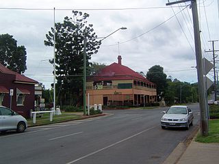
Mount Walker is a rural locality in the Scenic Rim Region, Queensland, Australia. In the 2021 census, Mount Walker had a population of 129 people.

Mount Forbes is a rural locality split between the City of Ipswich and the Scenic Rim Region, Queensland, Australia. In the 2021 census, Mount Forbes had a population of 262 people.

Harrisville is a rural town and locality in the Scenic Rim Region, Queensland, Australia. In the 2021 census, the locality of Harrisville had a population of 667 people.

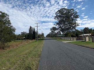
Mutdapilly is a rural locality in south-east Queensland, Australia. It is split between the local government areas of Scenic Rim Region and City of Ipswich. In the 2021 census, Mutdapilly had a population of 308 people.

Lower Mount Walker is a locality split between the Scenic Rim Region and City of Ipswich local government areas of South East Queensland, Australia. In the 2021 census, Lower Mount Walker had a population of 192 people.

Lanefield is a rural locality in the City of Ipswich, Queensland, Australia. In the 2021 census, Lanefield had a population of 97 people.
Mutdapilly State School is a heritage-listed state school at 4 Mutdapilly-Churchbank Weir Road, Mutdapilly, Scenic Rim Region, Queensland, Australia. It was designed by Richard George Suter and built from 1874 to 1880 by William Adams and Ben Denman. It is also known as Normanby National School. It was added to the Queensland Heritage Register on 10 October 2014.