
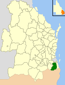
The Town of Southport was a local government area in South East Queensland, Australia.
The Town of Southport was a local government area in South East Queensland, Australia.
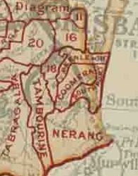
On 11 November 1879, the Nerang and Coomera Divisions was created as two of 74 divisions within Queensland under the Divisional Boards Act 1879. [1] [2]
On 6 July 1883, Southport Division was formed from part of subdivision No. 1 of Nerang Division and part of subdivision No. 1 of Coomera Division. [3] [4] [5] [6]
On 6 Feb 1889, part of Southport Division was separated to be a municipal Shire of Southport, [7] but this shire was abolished on 30 June 1892 and the original division was restored. [8]
With the passage of the Local Authorities Act 1902, the entire Southport Division became the Shire of Southport on 31 March 1903. [9]
On 12 April 1918, the Shire of Southport became the Town of Southport on 12 Apr 1918. [10]
A new town hall was in opened in 1935 and listed on the Queensland Heritage Register in 1998. [11]
On 9 December 1948, as part of a major reorganisation of local government in South East Queensland, an Order in Council replacing ten former local government areas between the City of Brisbane and the New South Wales border with only four. [12] [13] The former ten were:
The four resulting local government areas were:
The Order came into effect on 10 June 1949, when the first elections were held.
| Chairman | Term |
|---|---|
| Robert F. Johnston | 1883, 1900–1902 |
| William Charles Welsh | 1884–1889 |
| C. A. Beetham | 1890–1891 |
| George Andrews | 1892 |
| Thomas M. Kirk | 1893–1896 |
| W. Downs | 1897 |
| Edward Hicks | 1898 |
| Edward Proud | 1899 |
| Chairman | Term |
|---|---|
| Theodor Lenneberg | 1889 |
| William Lather | 1890–1891 |
| Edward Hicks | 1903, 1905, 1911 |
| Edward Fass | 1904, 1917 |
| C. A. Beetham | 1904* |
| Ernest Freeman | 1906, 1913–1916 |
| J. W. Proud | 1907 |
| H. Soegaard | 1908 |
| George Andrews | 1909, 1912 |
| John Siganto | 1910 |
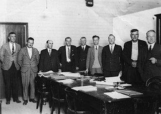
Following Southport's change of status to a Town, Edward Hicks was elected its first mayor at a meeting on 11 May 1918. From then on, mayors were popularly elected at triennial elections.
| Mayor | Term | Notes |
|---|---|---|
| Edward Hicks | 1918–1921 | |
| Edward Fass | 1921–1924 | |
| Washington Waters [15] | 1924–1927 | |
| Joseph Hendry Grice | 1927–1930 | |
| C. H. Steadman | 1930–1933 | |
| Henry Wilson | 1933–1936 | |
| Joseph Wood Proud | 1936–1948 | [16] |
| Party | Candidate | Votes | % | ±% | |
|---|---|---|---|---|---|
| Independent | J. W. Proud (elected) | 716 | |||
| Independent | J. R. Brown (elected) | 666 | |||
| Independent | M. T. Anderson (elected) | 568 | |||
| Independent | W. Waters (elected) | 511 | |||
| Independent | A. R. Andrews (elected) | 477 | |||
| Independent | E. H. Foreman (elected) | 476 | |||
| Independent | A. A. Ledbury | 475 | |||
| Independent | J. Shepard | 427 | |||
| Independent | V. H. Whelan | 423 | |||
| Independent | A. E. Reid | 398 | |||

The Logan River is a perennial river in the Scenic Rim, Logan and Gold Coast local government areas of the South East region of Queensland, Australia. The 184-kilometre (114 mi)-long river is one of the dominant waterways in South East Queensland that drains the southern ranges of the Scenic Rim and empties into Moreton Bay after navigating the City of Logan, a major suburban centre located south of Brisbane. The catchment is dominated by urban and agricultural land use. Near the river mouth are mangrove forests and a number of aquaculture farms.

Albert was a Legislative Assembly electorate in the state of Queensland which existed from 1887 to 1949 and 1959 to 2017.

The City of Gold Coast is the local government area spanning the Gold Coast, Queensland, Australia and surrounding areas. With a population of 606,774, it is the second most populous local government area in the State of Queensland. Its council maintains a staff of over 2,500. It was established in 1948, but has existed in its present form since 2008. It is on the border with New South Wales with the Tweed Shire to the south in New South Wales.

The South Coast railway line was a railway from Brisbane, the capital city of Queensland, Australia. The route via the South Coast to Tweed Heads on the border of Queensland and New South Wales. The line operated from 1889 to 1964. The Gold Coast railway line re-opened in 1996 along a modified alignment in the north and a new route south but does not extend as far south yet as the South Coast line.
The Shire of Beaudesert was a local government area located in South East Queensland, Australia, stretching from the New South Wales border, along the Gold Coast hinterland to the urban fringes of the cities of Brisbane and Ipswich. The Shire covered an area of 2,854.3 square kilometres (1,102.1 sq mi), and existed from 1879 until its abolition on 15 March 2008, following which it was split between Logan City and the new Scenic Rim Region.
The Shire of Albert was a local government area in Queensland, located south of the capital, Brisbane, and taking in areas to the north and west of the Gold Coast. It was named after the Prince Consort of the United Kingdom, and husband of Queen Victoria, Prince Albert. When created in 1948, it was primarily a rural area, but its growth started in earnest in the late 1960s with the development of Logan on Brisbane's southern frontier. After the separate creation of Logan as a shire in 1978, Albert lost most of its population and became more centred upon the Gold Coast, which experienced a massive period of growth from then until the Shire's amalgamation with the City of Gold Coast in 1995.
The Shire of Tingalpa was a local government area in the south-eastern suburbs of Brisbane, Queensland, Australia. The shire, administered from Mount Cotton, covered an area of 120 square miles (311 km2), and existed as a local government entity from 1879 until 1949.
The Mayor of the City of the Gold Coast is presiding officer and public face of the Gold Coast City Council, the local government body of the Gold Coast, Queensland. The current Mayor is Tom Tate.
The Shire of Beenleigh is a former local government area in the south-east of Queensland, Australia, centred on the town of Beenleigh. It existed from 1879 to 1949.

The Shire of Cleveland is a former local government area in the south-east of Queensland, Australia, centred on the town of Cleveland beside Moreton Bay.
The Shire of Waterford is a former local government area in the south-east of Queensland, Australia, centred on the town of Waterford. It existed between 1879 and 1948.

The Shire of Coomera was a local government area in South East Queensland, Australia. The shire, administered from Coomera, existed as a local government entity from 1879 until 1949.

The Shire of Nerang was a local government area in South East Queensland, Australia. The shire existed as a local government entity from 1879 until 1949.
The Shire of Tamborine was a local government area in South East Queensland, Australia, centred on the village of Tamborine. It existed from 1890 to 1949.
The Town of Coolangatta was a local government area in South East Queensland, Australia, centred on Coolangatta. It existed from 1914 to 1949.
The Town of South Coast was a local government area in South East Queensland, Australia.

Tamborine is a rural town in the Scenic Rim Region and a locality split between the Scenic Rim Region and the City of Logan in Queensland, Australia. In the 2021 census, the locality of Tamborine had a population of 4,388 people.
Beaudesert–Nerang Road is a major inter-regional arterial road that connects the township of Beaudesert with the Gold Coast via Canungra. The road commences in Nerang on the western edge of the Gold Coast and travels west through the Gold Coast hinterland and terminates in central Beaudesert at the intersection of Mount Lindesay Highway.
Beaudesert–Beenleigh Road is a continuous 35.5 kilometres (22.1 mi) road route in the Scenic Rim and Logan City regions of Queensland, Australia. Part of the road is signed as State Route 90 and the rest as State Route 92. Beaudesert–Beenleigh Road is a state-controlled road, part district and part regional.
The Tamborine Mountain road network is a group of roads that provide access to the mountain community from various lowland localities. The network ensures continuity of access in times of flooding or other natural disasters, and during planned maintenance activities. The locality of Tamborine Mountain includes a plateau that hosts a substantial residential community plus many tourism accommodation and activity venues.