
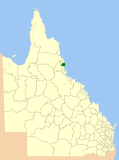
Chillagoe is a rural town and locality in the Shire of Mareeba, Queensland, Australia. In the 2016 census the locality of Chillagoe had a population of 251 people.

The Shire of Mareeba is a local government area at the base of Cape York Peninsula in Far North Queensland, inland from Cairns. The shire, administered from the town of Mareeba, covered an area of 53,491 square kilometres (20,653.0 sq mi), and existed as a local government entity from 1879 until 2008, when it amalgamated with several councils in the Atherton Tableland area to become the Tablelands Region.

The Shire of Booringa was a local government area in the Maranoa region of Queensland, Australia. The largest town and home of the shire administration was Mitchell. It existed from 1879 to 2008. The shire is now part of the Maranoa Region.

The Shire of Murweh is a local government area in the Maranoa district, which is part of South West Queensland, Australia. The administrative centre and largest town in the shire is Charleville. In June 2018, the Shire of Murweh had a population of 4,318.

The Shire of Nebo was a local government area in Central Queensland, Queensland, Australia, about 80 kilometres (50 mi) south-west of the regional city of Mackay. The Shire, administered from the town of Nebo, covered an area of 10,034.6 square kilometres (3,874.4 sq mi), and existed as a local government entity from 1883 until 2008, when it was amalgamated with the Shires of Belyando and Broadsound to form the Isaac Region.

The Shire of Dalrymple was a local government area located in North Queensland, Australia, and surrounded but did not include the town of Charters Towers, at which its council and administrative centre was based. It covered an area of 68,324.5 square kilometres (26,380.2 sq mi), and existed as a local government entity from 1879 until 2008, when it amalgamated with the separate City of Charters Towers to form the Charters Towers Region.

The Shire of Bowen was a local government area in the North Queensland region of Queensland, Australia. The shire, administered from the town of Bowen, covered an area of 21,184.4 square kilometres (8,179.3 sq mi), and existed as a local government entity from 1879 until 2008, when it amalgamated with the Shire of Whitsunday to form the Whitsunday Region.

The Shire of Croydon is a local government area in western Queensland, Australia. The shire, administered from the town of Croydon, covers an area of 29,498 square kilometres (11,389.2 sq mi). The council consists of a mayor plus four councillors, each of whom represents the entire Shire.

The Shire of Eacham was a local government area of Queensland. It was located on the Atherton Tableland, a plateau forming part of the Great Dividing Range west of the city of Cairns. The shire, administered from the town of Malanda, covered an area of 1,126.4 square kilometres (434.9 sq mi), and existed as a local government entity from 1910 until 2008, when it amalgamated with several other councils in the Tableland area to become the Tablelands Region.

The Shire of Herberton was a local government area of Queensland. It was located on the Atherton Tableland, a plateau forming part of the Great Dividing Range west of the city of Cairns. The shire, administered from the town of Herberton, covered an area of 9,607.0 square kilometres (3,709.3 sq mi), and existed as a local government entity from 1895 until 2008, when it amalgamated with several other councils in the Tableland area to become the Tablelands Region.
The Shire of Johnstone was a local government area of Queensland. It was located on the Coral Sea coast about 90 kilometres (56 mi) south of the city of Cairns. The shire, administered from the town of Innisfail, covered an area of 1,639.1 square kilometres (632.9 sq mi), and existed as a local government entity from 1881 until 2008, when it amalgamated with the Shire of Cardwell to form the Cassowary Coast Region.

The Shire of Cardwell was a local government area of Queensland. It was located on the Coral Sea coast about halfway between the cities of Cairns and Townsville. The shire, administered from the town of Tully, covered an area of 3,062.2 square kilometres (1,182.3 sq mi), and existed as a local government entity from 1884 until 2008, when it amalgamated with the Shire of Johnstone to form the Cassowary Coast Region.

The Shire of Atherton was a local government area of Queensland. It was located on the Atherton Tableland, a plateau forming part of the Great Dividing Range west of the city of Cairns. The shire, administered from the town of Atherton, covered an area of 623.1 square kilometres (240.6 sq mi), and existed as a local government entity from 1881 until 2008, when it amalgamated with several other councils in the Tableland area to become the Tablelands Region.

The Tablelands Region is a local government area in Far North Queensland, Australia inland from the city of Cairns. Established in 2008, it was preceded by four previous local government areas which dated back more than a century. On 1 January 2014, one of those local government areas, the Shire of Mareeba, was re-established independent of the Tablelands Region.

The Shire of Mulgrave was a local government area surrounding the City of Cairns in the Far North region of Queensland. The shire, administered from Cairns, covered an area of 1,718.3 square kilometres (663.4 sq mi), and existed as a local government entity from 1879 until 1995, when it was dissolved and amalgamated into the City of Cairns.
The Town of Cooktown is the former local government area for Cooktown in Far North Queensland, Australia. It existed from 1876 to 1932.

The Shire of Barron is a former local government area in Far North Queensland, Queensland, Australia. It existed between 1890 and 1919.
The Shire of Chillagoe was a local government area in Far North Queensland.

The Shire of Ravenswood was a local government area located in North Queensland, Australia. Its administrative centre was in Ravenswood.
The Town of Blackall was a local government area located in central Queensland, for the purposes of governing the town of Blackall. It exists from 1880 to 1931.
