
The Shire of Wangaratta was a local government area in the North Queensland region of Queensland, Australia.
The Shire of Wangaratta was a local government area in the North Queensland region of Queensland, Australia.
On 11 November 1879, Wangaratta Division was created on 11 November 1879 as one of 74 divisions around Queensland under the Divisional Boards Act 1879 with a population of 789. [1] [2]
With the passage of the Local Authorities Act 1902, Wangaratta Division became the Shire of Wangaratta on 31 March 1903. [2] [3] [4]


On 2 April 1960, the Shire of Wangaratta was amalgamated with the Town of Bowen creating the new Shire of Bowen. [3] [4] [5] [6]

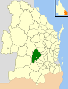
The Shire of Gayndah was a local government area located in the northern catchment of the Burnett River, Queensland, Australia. The shire covered an area of 2,709.3 square kilometres (1,046.1 sq mi), and existed as a local government area from 1866 until 2008, when it amalgamated with several other shires to form the North Burnett Region.

Shire of Broadsound was a local government area in the Capricornia region of Queensland, Australia. The Shire, administered from the town of St Lawrence, covered an area of 18,546.0 square kilometres (7,160.7 sq mi), and existed as a local government entity from 1879 until 2008, when it was amalgamated with the Shires of Belyando and Nebo to form the Isaac Region.

The Shire of Murilla was a local government area located in the Darling Downs region of Queensland, Australia. The shire, administered from the town of Miles, covered an area of 6,075.8 square kilometres (2,345.9 sq mi), and existed as a local government entity from 1879 until 2008, when it amalgamated with the Town of Dalby and the Shires of Chinchilla, Tara and Wambo and the southern part of Taroom to form the Western Downs Region.
The Shire of Wambo was a local government area in the Darling Downs region of Queensland, Australia. The shire surrounded but did not include the town of Dalby – which had its own municipal government. It covered an area of 5,709.7 square kilometres (2,204.5 sq mi), and existed as a local government entity from 1879 until 2008, when it amalgamated with the Town of Dalby and the Shires of Chinchilla, Murilla and Tara and the southern part of Taroom to form the Western Downs Region.
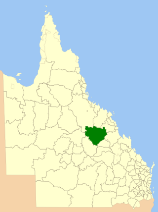
The Shire of Belyando was a local government area in Central Queensland, Australia. The Shire, administered from the town of Clermont, covered an area of 30,281.3 square kilometres (11,691.7 sq mi), and existed as a local government entity from 1879 until 2008, when it was amalgamated with the Shires of Broadsound and Nebo to form the Isaac Region.

The Shire of Nebo was a local government area in Central Queensland, Queensland, Australia, about 80 kilometres (50 mi) south-west of the regional city of Mackay. The Shire, administered from the town of Nebo, covered an area of 10,034.6 square kilometres (3,874.4 sq mi), and existed as a local government entity from 1883 until 2008, when it was amalgamated with the Shires of Belyando and Broadsound to form the Isaac Region.

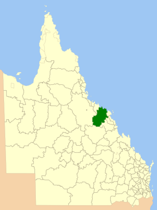
The Shire of Mirani was a local government area located in the North Queensland region of Queensland, Australia. The shire, administered from the town of Mirani, covered an area of 3,280.2 square kilometres (1,266.5 sq mi), and existed as a local government entity from 1916 until 2008, when it amalgamated with the City of Mackay and the Shire of Sarina to form the Mackay Region.
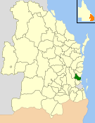
The Shire of Bowen was a local government area in the North Queensland region of Queensland, Australia. The shire, administered from the town of Bowen, covered an area of 21,184.4 square kilometres (8,179.3 sq mi), and existed as a local government entity from 1879 until 2008, when it amalgamated with the Shire of Whitsunday to form the Whitsunday Region.

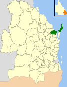
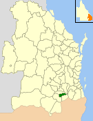
The Shire of Whitsunday was a local government area located in the North Queensland region of Queensland, Australia. The shire, administered from the town of Proserpine, covered an area of 2,678.3 square kilometres (1,034.1 sq mi), and existed as a local government entity from 1910 until 2008, when it amalgamated with the Shire of Bowen to form the Whitsunday Region.

The Shire of Tiaro was a local government area in the Wide Bay–Burnett region of Queensland, Australia, between the regional cities of Gympie and Hervey Bay about 220 kilometres (137 mi) north of the state capital, Brisbane. The shire covered an area of 2,185.3 square kilometres (843.7 sq mi), and existed as a local government area from 1879 until 2008, when it was dissolved and split between two new local government areas, the Gympie Region and the Fraser Coast Region.
The City of Hervey Bay was a local government area located in the Wide Bay–Burnett region of Queensland, Australia, containing the urban centre of Hervey Bay as well as the northern half of Fraser Island. The City covered an area of 2,356.3 square kilometres (909.8 sq mi), and existed as a local government entity in various forms from 1879 until 2008, when it was amalgamated with the City of Maryborough, Shire of Woocoo and the 1st and 2nd divisions of the Shire of Tiaro to form the Fraser Coast Region.
The Shire of Caboolture was a local government area located in the Australian state of Queensland on the northern urban fringe of the capital, Brisbane, and south of the Sunshine Coast. The Shire covered an area of 1,224.4 square kilometres (472.7 sq mi), of which approximately one-quarter was urban, and existed as a local government entity from 1879 until 2008, when it amalgamated with the City of Redcliffe and Shire of Pine Rivers to form the Moreton Bay Region, which was renamed the City of Moreton Bay in July 2023.
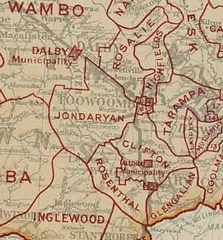
The Shire of Allora was a local government area north of the regional centre of Warwick in the Darling Downs region of Queensland. The shire, administered from Allora, covered an area of 702.0 square kilometres (271.0 sq mi), and existed as a local government entity from 1869 until 1994, when it was dissolved and amalgamated with City of Warwick, Shire of Rosenthal and Shire of Glengallan to form the Shire of Warwick.
The Shire of Glengallan was a local government area south and east of the regional centre of Warwick in the Darling Downs region of Queensland. The shire, administered from Warwick, covered an area of 1,699.6 square kilometres (656.2 sq mi), and existed as a local government entity from 1879 until 1994, when it was dissolved and amalgamated with City of Warwick, Shire of Rosenthal and Shire of Allora to form the Shire of Warwick.

The Shire of Rosenthal was a local government area south and west of the regional centre of Warwick in the Darling Downs region of Queensland. The shire, administered from Rosenthal Heights, a Warwick suburb, covered an area of 1,984.1 square kilometres (766.1 sq mi), and existed as a local government entity from 1886 until 1994, when it was dissolved and amalgamated with City of Warwick, Shire of Allora and Shire of Glengallan to form the Shire of Warwick.

The Shire of Cleveland is a former local government area in the south-east of Queensland, Australia, centred on the town of Cleveland beside Moreton Bay.
The Shire of Waterford is a former local government area in the south-east of Queensland, Australia, centred on the town of Waterford. It existed between 1879 and 1948.

The Shire of Coomera was a local government area in South East Queensland, Australia. The shire, administered from Coomera, existed as a local government entity from 1879 until 1949.

The Town of Southport was a local government area in South East Queensland, Australia.
The Shire of Drayton was a local government area in the Darling Downs region of Queensland, Australia, west of Toowoomba. It existed between 1887 and 1949.