
The Shire of Aramac was a local government area located in central Queensland about 1,100 kilometres (684 mi) north west of the state capital, Brisbane, between the towns of Barcaldine and Winton. It covered an area of 23,364.1 square kilometres (9,020.9 sq mi), and existed as a local government entity from 1879 until 2008, when it amalgamated with the Shires of Barcaldine and Jericho to form the Barcaldine Region.

The Shire of Gayndah was a local government area located in the northern catchment of the Burnett River, Queensland, Australia. The shire covered an area of 2,709.3 square kilometres (1,046.1 sq mi), and existed as a local government area from 1866 until 2008, when it amalgamated with several other shires to form the North Burnett Region.
The Shire of Kolan was a local government area located in the Wide Bay–Burnett region of Queensland, Australia, to the west of Bundaberg. The Shire, administered from the town of Gin Gin, covered an area of 2,650.6 square kilometres (1,023.4 sq mi), and existed as a local government entity from 1879 until 2008, when it was amalgamated with the City of Bundaberg and the Shires of Burnett and Isis to form the Bundaberg Region.

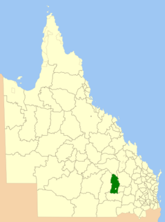
The Shire of Bauhinia was a local government area in Central Queensland, Queensland, Australia. The Shire, administered from the town of Springsure, covered an area of 23,649.6 square kilometres (9,131.2 sq mi), and existed as a local government entity from 1879 until 2008, when it was amalgamated with the Shires of Duaringa, Emerald and Peak Downs to form the Central Highlands Region.

The Shire of Waggamba was a local government area of Queensland, Australia on the Queensland-New South Wales border in the Darling Downs region, surrounding the Town of Goondiwindi, a separate local government area limited to the town. Administered from the town of Goondiwindi, it covered an area of 13,400.8 square kilometres (5,174.1 sq mi), and existed as a local government entity from 1879 until 2008, when it amalgamated with the Shire of Inglewood and the Town of Goondiwindi to form the Goondiwindi Region.
The Shire of Wambo was a local government area in the Darling Downs region of Queensland, Australia. The shire surrounded but did not include the town of Dalby – which had its own municipal government. It covered an area of 5,709.7 square kilometres (2,204.5 sq mi), and existed as a local government entity from 1879 until 2008, when it amalgamated with the Town of Dalby and the Shires of Chinchilla, Murilla and Tara and the southern part of Taroom to form the Western Downs Region.
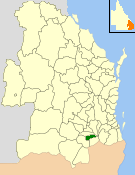
The Shire of Bungil was a local government area in the Maranoa region of Queensland, Australia. It existed from 1880 to 2008.

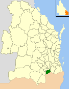
The Shire of Booringa was a local government area in the Maranoa region of Queensland, Australia. The largest town and home of the shire administration was Mitchell. It existed from 1879 to 2008. The shire is now part of the Maranoa Region.

The Shire of Murweh is a local government area in the Maranoa district, which is part of South West Queensland, Australia. The administrative centre and largest town in the shire is Charleville. In June 2018, the Shire of Murweh had a population of 4,318.

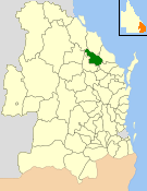
The Shire of Tambo was a local government area located in central Queensland south-east of the town of Blackall. It covered an area of 14,083.8 square kilometres (5,437.8 sq mi), and existed as a local government entity from 1881 until 2008, when it amalgamated with neighbouring Shire of Blackall to form the Blackall-Tambo Region.

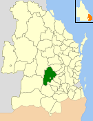
The Shire of Blackall was a local government area located in central Queensland around the town of Blackall. It covered an area of 16,366.8 square kilometres (6,319.3 sq mi), and existed as a local government entity from 1879 until 2008, when it amalgamated with neighbouring Shire of Tambo to form the Blackall-Tambo Region.

The Shire of Nebo was a local government area in Central Queensland, Queensland, Australia, about 80 kilometres (50 mi) south-west of the regional city of Mackay. The Shire, administered from the town of Nebo, covered an area of 10,034.6 square kilometres (3,874.4 sq mi), and existed as a local government entity from 1883 until 2008, when it was amalgamated with the Shires of Belyando and Broadsound to form the Isaac Region.

The Shire of Dalrymple was a local government area located in North Queensland, Australia, and surrounded but did not include the town of Charters Towers, at which its council and administrative centre was based. It covered an area of 68,324.5 square kilometres (26,380.2 sq mi), and existed as a local government entity from 1879 until 2008, when it amalgamated with the separate City of Charters Towers to form the Charters Towers Region.
The Shire of Allora was a local government area north of the regional centre of Warwick in the Darling Downs region of Queensland. The shire, administered from Allora, covered an area of 702.0 square kilometres (271.0 sq mi), and existed as a local government entity from 1869 until 1994, when it was dissolved and amalgamated with City of Warwick, Shire of Rosenthal and Shire of Glengallan to form the Shire of Warwick.
The Shire of Glengallan was a local government area south and east of the regional centre of Warwick in the Darling Downs region of Queensland. The shire, administered from Warwick, covered an area of 1,699.6 square kilometres (656.2 sq mi), and existed as a local government entity from 1879 until 1994, when it was dissolved and amalgamated with City of Warwick, Shire of Rosenthal and Shire of Allora to form the Shire of Warwick.

The Shire of Rosenthal was a local government area south and west of the regional centre of Warwick in the Darling Downs region of Queensland. The shire, administered from Rosenthal Heights, a Warwick suburb, covered an area of 1,984.1 square kilometres (766.1 sq mi), and existed as a local government entity from 1886 until 1994, when it was dissolved and amalgamated with City of Warwick, Shire of Allora and Shire of Glengallan to form the Shire of Warwick.

The City of Warwick was a local government area administering the regional centre of Warwick in the Darling Downs region of Queensland. The City covered an area of 25.1 square kilometres (9.7 sq mi), and existed as a local government entity from 1861 until 1994, when it was dissolved and amalgamated with Shire of Allora, Shire of Rosenthal and Shire of Glengallan to form the Shire of Warwick.

The Shire of Adavale is a former local government area in the south-east of Queensland, Australia, centred on the town of Adavale. It existed from 1879 to 1930.
The Shire of Walsh was a local government area in Far North Queensland, Australia, located to the south-west of the town Cairns.

The Shire of Ravenswood was a local government area located in North Queensland, Australia. Its administrative centre was in Ravenswood.


