
The Shire of Paroo is a local government area in South West Queensland, Australia. The administrative centre is the town of Cunnamulla. The Paroo Shire covers an area of 47,623 square kilometres (18,387 sq mi). In the 2021 census, the Shire of Paroo had a population of 1,679 people.

The Shire of Mareeba is a local government area at the base of Cape York Peninsula in Far North Queensland, inland from Cairns. The shire, administered from the town of Mareeba, covered an area of 53,491 square kilometres (20,653.0 sq mi), and existed as a local government entity from 1879 until 2008, when it amalgamated with several councils in the Atherton Tableland area to become the Tablelands Region.

The Shire of Aramac was a local government area located in central Queensland about 1,100 kilometres (684 mi) north west of the state capital, Brisbane, between the towns of Barcaldine and Winton. It covered an area of 23,364.1 square kilometres (9,020.9 sq mi), and existed as a local government entity from 1879 until 2008, when it amalgamated with the Shires of Barcaldine and Jericho to form the Barcaldine Region.

The Shire of Gayndah was a local government area located in the northern catchment of the Burnett River, Queensland, Australia. The shire covered an area of 2,709.3 square kilometres (1,046.1 sq mi), and existed as a local government area from 1866 until 2008, when it amalgamated with several other shires to form the North Burnett Region.

The Shire of Bungil was a local government area in the Maranoa region of Queensland, Australia. It existed from 1880 to 2008.

The Shire of Booringa was a local government area in the Maranoa region of Queensland, Australia. The largest town and home of the shire administration was Mitchell. It existed from 1879 to 2008. The shire is now part of the Maranoa Region.
The Shire of Tambo was a local government area located in central Queensland south-east of the town of Blackall. It covered an area of 14,083.8 square kilometres (5,437.8 sq mi), and existed as a local government entity from 1881 until 2008, when it amalgamated with neighbouring Shire of Blackall to form the Blackall-Tambo Region.

The Shire of Blackall was a local government area located in central Queensland around the town of Blackall. It covered an area of 16,366.8 square kilometres (6,319.3 sq mi), and existed as a local government entity from 1879 until 2008, when it amalgamated with neighbouring Shire of Tambo to form the Blackall-Tambo Region.

The Shire of Barcaldine was a local government area located in central Queensland and headquartered in the town of Barcaldine. It covered an area of 8,448.4 square kilometres (3,261.9 sq mi), and existed as a local government entity from 1892 until 2008, when it amalgamated with the Shires of Aramac and Jericho to form the Barcaldine Region.

The Shire of Johnstone was a local government area of Queensland. It was located on the Coral Sea coast about 90 kilometres (56 mi) south of the city of Cairns. The shire, administered from the town of Innisfail, covered an area of 1,639.1 square kilometres (632.9 sq mi), and existed as a local government entity from 1881 until 2008, when it amalgamated with the Shire of Cardwell to form the Cassowary Coast Region.

The Shire of Cardwell was a local government area of Queensland. It was located on the Coral Sea coast about halfway between the cities of Cairns and Townsville. The shire, administered from the town of Tully, covered an area of 3,062.2 square kilometres (1,182.3 sq mi), and existed as a local government entity from 1884 until 2008, when it amalgamated with the Shire of Johnstone to form the Cassowary Coast Region.

The Shire of Atherton was a local government area of Queensland. It was located on the Atherton Tableland, a plateau forming part of the Great Dividing Range west of the city of Cairns. The shire, administered from the town of Atherton, covered an area of 623.1 square kilometres (240.6 sq mi), and existed as a local government entity from 1881 until 2008, when it amalgamated with several other councils in the Tableland area to become the Tablelands Region.

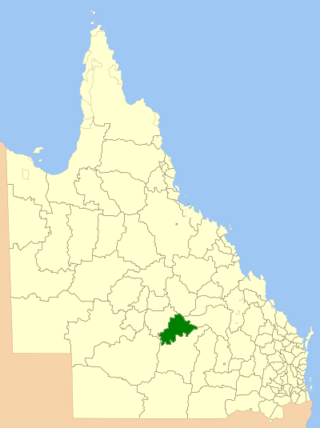
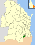
The Blackall-Tambo Region is a local government area in Central West Queensland, Australia. Established in 2008, it was preceded by two previous local government areas dating from the 1870s.
The Shire of Glengallan was a local government area south and east of the regional centre of Warwick in the Darling Downs region of Queensland. The shire, administered from Warwick, covered an area of 1,699.6 square kilometres (656.2 sq mi), and existed as a local government entity from 1879 until 1994, when it was dissolved and amalgamated with City of Warwick, Shire of Rosenthal and Shire of Allora to form the Shire of Warwick.
The Shire of Tingalpa was a local government area in the south-eastern suburbs of Brisbane, Queensland, Australia. The shire, administered from Mount Cotton, covered an area of 120 square miles (311 km2), and existed as a local government entity from 1879 until 1949.

The Shire of Adavale is a former local government area in the south-east of Queensland, Australia, centred on the town of Adavale. It existed from 1879 to 1930.

The Shire of Nerang was a local government area in South East Queensland, Australia. The shire existed as a local government entity from 1879 until 1949.

The City of Gympie is a former local government area in the south-east of Queensland, Australia, responsible for governing Gympie.
The Town of Cooktown is the former local government area for Cooktown in Far North Queensland, Australia. It existed from 1876 to 1932.
The Shire of Walsh was a local government area in Far North Queensland, Australia, located to the south-west of the town Cairns.
