
Biggenden is a rural town and locality in the North Burnett Region, Queensland, Australia. In the 2016 census, Biggenden had a population of 845 people.

The Shire of Perry was a local government area in the northern catchment of the Burnett River, Queensland, Australia. The Shire covered an area of 2,357.7 square kilometres (910.3 sq mi), and existed as a local government area from 1880 until 2008, when it amalgamated with several other shires to form the North Burnett Region.

The Shire of Wondai was a local government area located in the South Burnett region of Queensland, Australia, about 140 kilometres (87 mi) northwest of the capital, Brisbane. The shire covered an area of 3,577.6 square kilometres (1,381.3 sq mi), and existed as a local government entity from 1910 until 2008, when it amalgamated with several other councils in the South Burnett area to form the South Burnett Region.

The Shire of Aramac was a local government area located in central Queensland about 1,100 kilometres (684 mi) north west of the state capital, Brisbane, between the towns of Barcaldine and Winton. It covered an area of 23,364.1 square kilometres (9,020.9 sq mi), and existed as a local government entity from 1879 until 2008, when it amalgamated with the Shires of Barcaldine and Jericho to form the Barcaldine Region.
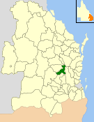
The Shire of Mundubbera was a local government area in the northern catchment of the Burnett River, Queensland, Australia. The shire covered an area of 4,192.8 square kilometres (1,618.8 sq mi), and existed as a local government area from 1915 until 2008, when it amalgamated with several other shires to form the North Burnett Region.

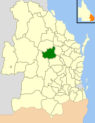
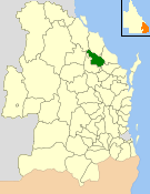
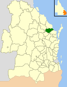
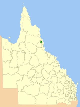
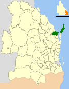
The Shire of Gayndah was a local government area located in the northern catchment of the Burnett River, Queensland, Australia. The shire covered an area of 2,709.3 square kilometres (1,046.1 sq mi), and existed as a local government area from 1866 until 2008, when it amalgamated with several other shires to form the North Burnett Region.

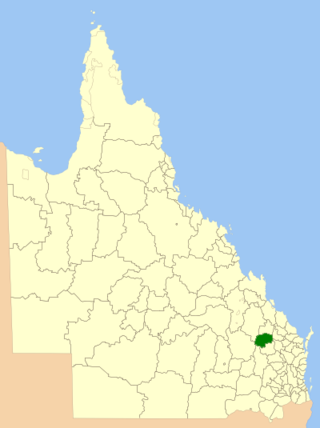
The Shire of Monto was a local government area in the northern catchment of the Burnett River, Queensland, Australia. The shire covered an area of 4,320.8 square kilometres (1,668.3 sq mi), and existed as a local government area from 1932 until 2008, when it amalgamated with several other shires to form the North Burnett Region.
The Shire of Kingaroy was a local government area in the South Burnett area of Queensland, Australia, about 100 kilometres (62 mi) northwest of the capital, Brisbane. The shire covered an area of 2,420.3 square kilometres (934.5 sq mi), and existed as a local government area from 1912 until 2008, when it amalgamated with a number of other local government areas in the South Burnett area to become the South Burnett Region.
The Shire of Nanango was a local government area located in the South Burnett region of Queensland, Australia, about 100 kilometres (62 mi) northwest of the capital, Brisbane. The Shire covered an area of 1,738.4 square kilometres (671.2 sq mi), and existed as a local government entity from 1879 until 2008, when it amalgamated with several other councils in the South Burnett area to become the South Burnett Regional Council.
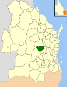
The Shire of Eidsvold was a local government area in the northern catchment of the Burnett River, Queensland, Australia. The shire covered an area of 4,809.4 square kilometres (1,856.9 sq mi), and existed as a local government area from 1890 until 2008, when it amalgamated with several other shires to form the North Burnett Region.
The Shire of Kolan was a local government area located in the Wide Bay–Burnett region of Queensland, Australia, to the west of Bundaberg. The Shire, administered from the town of Gin Gin, covered an area of 2,650.6 square kilometres (1,023.4 sq mi), and existed as a local government entity from 1879 until 2008, when it was amalgamated with the City of Bundaberg and the Shires of Burnett and Isis to form the Bundaberg Region.
The Shire of Isis was a local government area located in the Wide Bay–Burnett region of Queensland, Australia, to the south of Bundaberg. The Shire, administered from the town of Childers covered an area of 1,702.2 square kilometres (657.2 sq mi), and existed as a local government entity from 1887 until 2008, when it was amalgamated with the City of Bundaberg and the Shires of Burnett and Kolan to form the Bundaberg Region.

The Shire of Bendemere was a local government area in the Maranoa region of Queensland, Australia, and existed from 1911 until 2008 when it amalgamated into Maranoa Region. The Shire, administered from the town of Yuleba, covered an area of 3,926.8 square kilometres (1,516.1 sq mi), and existed as a local government entity from 1911 until 2008, when it was amalgamated with the Town of Roma and the Shires of Booringa, Bungil and Warroo to form the Maranoa Region.

The Shire of Tiaro was a local government area in the Wide Bay–Burnett region of Queensland, Australia, between the regional cities of Gympie and Hervey Bay about 220 kilometres (137 mi) north of the state capital, Brisbane. The shire covered an area of 2,185.3 square kilometres (843.7 sq mi), and existed as a local government area from 1879 until 2008, when it was dissolved and split between two new local government areas, the Gympie Region and the Fraser Coast Region.
The Shire of Eacham was a local government area of Queensland. It was located on the Atherton Tableland, a plateau forming part of the Great Dividing Range west of the city of Cairns. The shire, administered from the town of Malanda, covered an area of 1,126.4 square kilometres (434.9 sq mi), and existed as a local government entity from 1910 until 2008, when it amalgamated with several other councils in the Tableland area to become the Tablelands Region.

The Shire of Boonah was a local government area in South East Queensland, Australia, about 80 kilometres (50 mi) southwest of Brisbane. The shire covered an area of 1,921.6 square kilometres (741.9 sq mi), and existed from 1880 until its merger with parts of the Shire of Beaudesert and City of Ipswich to form the Scenic Rim Region on 15 March 2008.
The City of Hervey Bay was a local government area located in the Wide Bay–Burnett region of Queensland, Australia, containing the urban centre of Hervey Bay as well as the northern half of Fraser Island. The City covered an area of 2,356.3 square kilometres (909.8 sq mi), and existed as a local government entity in various forms from 1879 until 2008, when it was amalgamated with the City of Maryborough, Shire of Woocoo and the 1st and 2nd divisions of the Shire of Tiaro to form the Fraser Coast Region.

The North Burnett Region is a local government area in Queensland, Australia in the northern catchment of the Burnett River. Established in 2008, it was preceded by several previous local government areas with histories extending back to the early 1900s.

Degilbo is a rural town and locality in the North Burnett Region, Queensland, Australia. In the 2016 census, the locality of Degilbo had a population of 174 people.

The Shire of Normanby is a former local government area in the south-east of Queensland, Australia. Its administrative centre was in Harrisville.

