
The Town of Toowong is a former local government area of Queensland, Australia, located in western Brisbane in the area around the current suburb of Toowong.
The Town of Toowong is a former local government area of Queensland, Australia, located in western Brisbane in the area around the current suburb of Toowong.
The Toowong Division was established on 11 November 1879 under the Divisional Boards Act 1879 with a population of 1789. [1] [2]
In May 1880, the more populated part of Toowong Division was proclaimed the Shire of Toowong, [3] [4] while the remaining part of the Toowong Division was renamed Indooroopilly Division. [2] [5] [6]
In 1902, the Local Authorities Act 1902 replaced all Divisions and Boroughs with Towns and Shires, creating the Town of Toowong on 31 March 1903. [6] [7]
On 1 October 1925, it was amalgamated into the City of Brisbane. [7]
The following men served as the president of the Shire of Toowong and the mayors of the Town of Toowong. [8]

Sir Augustus Charles Gregory was an English-born Australian explorer and surveyor. Between 1846 and 1858 he undertook four major expeditions. He was the first Surveyor-General of Queensland. He was appointed a lifetime Member of the Queensland Legislative Council.

Toowong is an inner suburb of the City of Brisbane, Queensland, Australia.

Jamboree Heights is a south-western suburb in the City of Brisbane, Queensland, Australia. In the 2016 census, Jamboree Heights had a population of 3,093 people.

Riverhills is a south-western suburb in the City of Brisbane, Queensland, Australia. It is one of the Centenary suburbs. In the 2016 census, Riverhills had a population of 4,042 people.

The Shire of Murweh is a local government area in the Maranoa district, which is part of South West Queensland, Australia. The administrative centre and largest town in the shire is Charleville. In June 2018, the Shire of Murweh had a population of 4,318.

The Shire of Tiaro was a local government area in the Wide Bay–Burnett region of Queensland, Australia, between the regional cities of Gympie and Hervey Bay about 220 kilometres (137 mi) north of the state capital, Brisbane. The shire covered an area of 2,185.3 square kilometres (843.7 sq mi), and existed as a local government area from 1879 until 2008, when it was dissolved and split between two new local government areas, the Gympie Region and the Fraser Coast Region.

The City of Warwick was a local government area administering the regional centre of Warwick in the Darling Downs region of Queensland. The City covered an area of 25.1 square kilometres (9.7 sq mi), and existed as a local government entity from 1861 until 1994, when it was dissolved and amalgamated with Shire of Allora, Shire of Rosenthal and Shire of Glengallan to form the Shire of Warwick.
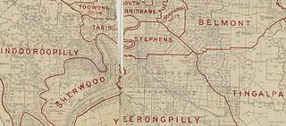
The Shire of Stephens was a local government area in the inner southern suburbs of Brisbane, Queensland, Australia. The shire, administered from Annerley, covered an area of 9 square miles (23 km2), and existed as a local government entity from 1886 until 1925, when it was amalgamated into the City of Brisbane under the City of Brisbane Act 1924.

Robert Cribb (7 January 1805 – 16 April 1893) was an Australian parliamentarian who represented the district of East Moreton in the New South Wales Legislative Assembly, and the districts of Town of Brisbane and East Moreton in the Queensland Legislative Assembly after the separation of Queensland from New South Wales. Cribb's brother Benjamin Cribb also served as a member of the colonial parliaments of both New South Wales and Queensland.

The Town of Hamilton is a former local government area of Queensland, Australia, located in north-eastern Brisbane.

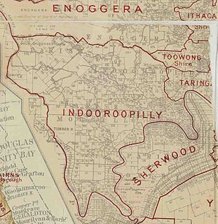
The Shire of Enoggera is a former local government area of Queensland, Australia, located in north-western Brisbane.

The Shire of Toombul was a local government area of Queensland, Australia, located in northern Brisbane from 1883 to 1925.
The Shire of Moggill is a former local government area of Queensland, Australia, located in western Brisbane.

The Shire of Taringa is a former local government area of Queensland, Australia, located in western Brisbane. Its administrative centre was Taringa. It existed from 1890 to 1925.

The Shire of Adavale is a former local government area in the south-east of Queensland, Australia, centred on the town of Adavale. It existed from 1879 to 1930.

The Shire of Nerang was a local government area in South East Queensland, Australia. The shire existed as a local government entity from 1879 until 1949.

The City of Gympie is a former local government area in the south-east of Queensland, Australia, responsible for governing Gympie.
The Shire of Gowrie was a local government area in the Darling Downs region of Queensland, Australia.
The Shire of Widgee is a former local government area in the Wide Bay–Burnett area of Queensland, Australia. It was located in the rural areas around the town of Gympie but did not include the town itself, which was always in a separate local government area. The administrative offices of the Shire of Widgee were located in Gympie.
The Town of Blackall was a local government area located in central Queensland, for the purposes of governing the town of Blackall. It exists from 1880 to 1931.