
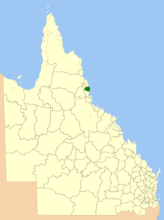
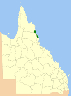
The Shire of Barron is a former local government area in Far North Queensland, Queensland, Australia. It existed between 1890 and 1919.
The Shire of Barron is a former local government area in Far North Queensland, Queensland, Australia. It existed between 1890 and 1919.
Under the Divisional Boards Act 1879, the Cairns Division, Hinchinbrook Division and Woothakata Division were created on 11 November 1879. On 3 September 1881, parts of each of these three divisions were excised to create the new Tinaroo Division. In 1889, residents of the No. 3 subdivision of Tinnaroo Division began to agitate for an independent division. [1] On 20 December 1890, part of the Tinaroo Division was excised to create the new Barron Division. [2]
With the passage of the Local Authorities Act 1902, the Barron Division became the Shire of Barron on 31 March 1903. [2] [3]
On 20 December 1919, the Shire of Barron was abolished and was split between the Shires of Cairns and Woothakata. [3]

The Barron River is located on the Atherton Tablelands inland from Cairns in northern Queensland, Australia. With its headwaters below Mount Hypipamee, the 165-kilometre (103 mi)-long river with a catchment area of approximately 2,138 square kilometres (825 sq mi) forms through run off from the Mount Hypipamee National Park, flows through Lake Tinaroo, and eventually empties into the Coral Sea near Smithfield.

The Shire of Mareeba is a local government area at the base of Cape York Peninsula in Far North Queensland, inland from Cairns. The shire, administered from the town of Mareeba, covered an area of 53,491 square kilometres (20,653.0 sq mi), and existed as a local government entity from 1879 until 2008, when it amalgamated with several councils in the Atherton Tableland area to become the Tablelands Region.

The Shire of Aramac was a local government area located in central Queensland about 1,100 kilometres (684 mi) north west of the state capital, Brisbane, between the towns of Barcaldine and Winton. It covered an area of 23,364.1 square kilometres (9,020.9 sq mi), and existed as a local government entity from 1879 until 2008, when it amalgamated with the Shires of Barcaldine and Jericho to form the Barcaldine Region.

The Shire of Eacham was a local government area of Queensland. It was located on the Atherton Tableland, a plateau forming part of the Great Dividing Range west of the city of Cairns. The shire, administered from the town of Malanda, covered an area of 1,126.4 square kilometres (434.9 sq mi), and existed as a local government entity from 1910 until 2008, when it amalgamated with several other councils in the Tableland area to become the Tablelands Region.

The Shire of Herberton was a local government area of Queensland. It was located on the Atherton Tableland, a plateau forming part of the Great Dividing Range west of the city of Cairns. The shire, administered from the town of Herberton, covered an area of 9,607.0 square kilometres (3,709.3 sq mi), and existed as a local government entity from 1895 until 2008, when it amalgamated with several other councils in the Tableland area to become the Tablelands Region.
The Shire of Johnstone was a local government area of Queensland. It was located on the Coral Sea coast about 90 kilometres (56 mi) south of the city of Cairns. The shire, administered from the town of Innisfail, covered an area of 1,639.1 square kilometres (632.9 sq mi), and existed as a local government entity from 1881 until 2008, when it amalgamated with the Shire of Cardwell to form the Cassowary Coast Region.

The Shire of Cardwell was a local government area of Queensland. It was located on the Coral Sea coast about halfway between the cities of Cairns and Townsville. The shire, administered from the town of Tully, covered an area of 3,062.2 square kilometres (1,182.3 sq mi), and existed as a local government entity from 1884 until 2008, when it amalgamated with the Shire of Johnstone to form the Cassowary Coast Region.

The Shire of Atherton was a local government area of Queensland. It was located on the Atherton Tableland, a plateau forming part of the Great Dividing Range west of the city of Cairns. The shire, administered from the town of Atherton, covered an area of 623.1 square kilometres (240.6 sq mi), and existed as a local government entity from 1881 until 2008, when it amalgamated with several other councils in the Tableland area to become the Tablelands Region.

The Shire of Hinchinbrook is a local government area in North Queensland, Queensland, Australia. The shire, administered from the town of Ingham, covers an area of 2,807 square kilometres (1,083.8 sq mi), and has existed since its creation on 11 November 1879 as one of 74 divisions around Queensland under the Divisional Boards Act 1879.

The Shire of Clifton was a local government area in the Darling Downs region of Queensland, Australia, southwest of the regional city of Toowoomba. The shire, administered from the town of Clifton, covered an area of 867.5 square kilometres (334.9 sq mi), and existed as a local government entity from 1879 until 2008, when it amalgamated with several other councils in the Toowoomba area to form the Toowoomba Region.

The Tablelands Region is a local government area in Far North Queensland, Australia inland from the city of Cairns. Established in 2008, it was preceded by four previous local government areas which dated back more than a century. On 1 January 2014, one of those local government areas, the Shire of Mareeba, was re-established independent of the Tablelands Region.
The Cairns Region is a local government area in Far North Queensland, Queensland, Australia, centred on the regional centre of Cairns. It was established in 2008 by the amalgamation of the City of Cairns and the Shire of Douglas. However, following public protest and a referendum in 2013, on 1 January 2014, the Shire of Douglas was separated from the Cairns Region and re-established as a local government authority.

The Shire of Mulgrave was a local government area surrounding the City of Cairns in the Far North region of Queensland. The shire, administered from Cairns, covered an area of 1,718.3 square kilometres (663.4 sq mi); it existed as a local government entity from 1879 until 1995, when it was dissolved and amalgamated into the City of Cairns.

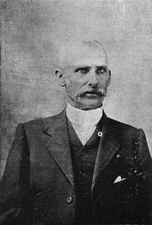
Richard Alfred Tills (1860–1937) was the fourth mayor of Cairns, Australia and the twelfth chairman when Cairns was classified as a borough, a member of the Barron Divisional Board, and president of the Cairns Chamber of Commerce. Born in Kingston upon Hull, England, Tills was a carpenter, architect and one of the pioneers of North Queensland.
The Town of Toowong is a former local government area of Queensland, Australia, located in western Brisbane in the area around the current suburb of Toowong.

The Shire of Coorparoo is a former local government area of Queensland, Australia, located in eastern Brisbane.
The Town of Normanton is a former local government area for the town of Normanton in North Queensland, Australia. It existed from 1886 to 1910.
The Shire of Walsh was a local government area in Far North Queensland, Australia, located to the south-west of the town Cairns.
The Shire of Queenton was a local government area located in North Queensland, Australia. It was located to the south of Charters Towers and existed from 1902 to 1916.

John Newell was a member of the Queensland Legislative Assembly.