Inglewood is a rural town and locality in the Goondiwindi Region, Queensland, Australia. In the 2016 census, the locality of Inglewood had a population of 954 people, making Inglewood the second largest town in the Goondiwindi Region.
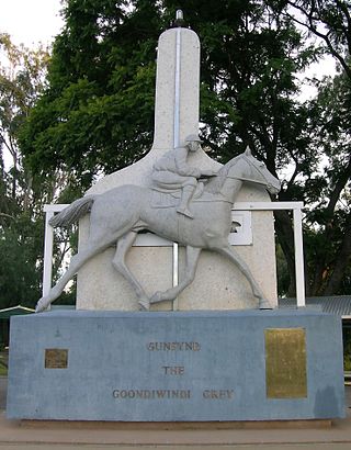
Goondiwindi is a rural town and locality in the Goondiwindi Region, Queensland, Australia. It is on the border of Queensland and New South Wales. In the 2016 census, Goondiwindi had a population of 6,355 people.

The Shire of Calliope was a local government area in the Capricornia region of Queensland, Australia. It was centred on the town of Calliope.

The Shire of Mount Morgan was a local government area located in the Capricornia region of Central Queensland, Queensland, Australia, about 20 kilometres (12 mi) south of the regional city of Rockhampton. The shire, roughly the region surrounding the former gold mining town of Mount Morgan, covered an area of 492.0 square kilometres (190.0 sq mi), and existed as a local government entity from 1890 until 2008, when it amalgamated with several other councils to become the Rockhampton Region.

The Shire of Miriam Vale was a local government area near Gladstone in Queensland, Australia. The administrative centre was the town of Miriam Vale.

The Shire of Waggamba was a local government area of Queensland, Australia on the Queensland-New South Wales border in the Darling Downs region, surrounding the Town of Goondiwindi, a separate local government area limited to the town. Administered from the town of Goondiwindi, it covered an area of 13,400.8 square kilometres (5,174.1 sq mi), and existed as a local government entity from 1879 until 2008, when it amalgamated with the Shire of Inglewood and the Town of Goondiwindi to form the Goondiwindi Region.

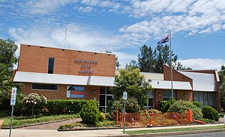
The Shire of Inglewood was a local government area of Queensland, Australia on the Queensland-New South Wales border in the Darling Downs region, about halfway between the towns of Goondiwindi and Warwick. Administered from the town of Inglewood, it covered an area of 5,876.7 square kilometres (2,269.0 sq mi), and existed as a local government entity from 1879 until 2008, when it amalgamated with the Shire of Waggamba and the Town of Goondiwindi to form the Goondiwindi Region.

The Shire of Johnstone was a local government area of Queensland. It was located on the Coral Sea coast about 90 kilometres (56 mi) south of the city of Cairns. The shire, administered from the town of Innisfail, covered an area of 1,639.1 square kilometres (632.9 sq mi), and existed as a local government entity from 1881 until 2008, when it amalgamated with the Shire of Cardwell to form the Cassowary Coast Region.

The Shire of Woocoo was a local government area located in the Wide Bay–Burnett region of Queensland, Australia, containing the rural residential area to the west of the town of Maryborough, and surrounding countryside. The shire covered an area of 2,007.9 square kilometres (775.3 sq mi), and existed as a local government entity from 1914 until 2008, when it was amalgamated with the City of Maryborough, City of Hervey Bay and the 1st and 2nd divisions of the Shire of Tiaro to form the Fraser Coast Region.

The City of Maryborough was a local government area located in the Wide Bay–Burnett region of Queensland, Australia, containing the urban locality of Maryborough as well as the southern half of Fraser Island. The City covered an area of 1,233.9 square kilometres (476.4 sq mi), and existed as a local government entity from 1861 until 2008, when it was amalgamated with the City of Hervey Bay, Shire of Woocoo and the 1st and 2nd divisions of the Shire of Tiaro to form the Fraser Coast Region.

The Town of Dalby was a local government area of Queensland, Australia which managed the affairs of Dalby. It was located 85 kilometres (53 mi) north-west of Toowoomba. It was amalgamated into the Western Downs Region in 2008.

The Town of Roma was a local government area in the western Downs region of Queensland, Australia. The Town of Roma covered the urban area of Roma and was surrounded by the neighbouring Shire of Bungil. Today it is part of the Maranoa Region. At the 2011 census the Town had a population of 6,906

The City of Mackay was a local government area located in the Central Queensland region of Queensland, Australia, encompassing the regional city of Mackay and the surrounding region. The City was created as a municipal borough in 1869, and prior to amalgamation with the Shire of Pioneer in 1994, the City was limited to the central suburbs on the south shore of the Pioneer River. From 1994 until 2008, the City covered an area of 2,897.5 square kilometres (1,118.7 sq mi). In 2008, it amalgamated with the Shires of Mirani and Sarina to become the Mackay Regional Council.

The City of Redcliffe is a former local government area in South East Queensland, Australia. In 2008 it was amalgamated with the Shires of Pine Rivers and Caboolture to create Moreton Bay Region. It is in the northern part of the County of Stanley, with a total area of 38.1 km² and a population of 51,174.

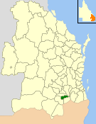
The Goondiwindi Region is a local government area located in the Darling Downs region of Queensland, Australia along the state's border with New South Wales. Established in 2008, it was preceded by three previous local government areas which dated back to the 19th century.
The Shire of Allora was a local government area north of the regional centre of Warwick in the Darling Downs region of Queensland. The shire, administered from Allora, covered an area of 702.0 square kilometres (271.0 sq mi), and existed as a local government entity from 1869 until 1994, when it was dissolved and amalgamated with City of Warwick, Shire of Rosenthal and Shire of Glengallan to form the Shire of Warwick.

The City of Warwick was a local government area administering the regional centre of Warwick in the Darling Downs region of Queensland. The City covered an area of 25.1 square kilometres (9.7 sq mi), and existed as a local government entity from 1861 until 1994, when it was dissolved and amalgamated with Shire of Allora, Shire of Rosenthal and Shire of Glengallan to form the Shire of Warwick.

The Shire of Adavale is a former local government area in the south-east of Queensland, Australia, centred on the town of Adavale. It existed from 1879 to 1930.

The City of Gympie is a former local government area in the south-east of Queensland, Australia, responsible for governing Gympie.
The Town of Charleville is a former local government area in the Maranoa area of Queensland, Australia. It existed from 1894 to 1960.

