
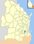
The Shire of Normanby is a former local government area in the south-east of Queensland, Australia. Its administrative centre was in Harrisville. [1]
The Shire of Normanby is a former local government area in the south-east of Queensland, Australia. Its administrative centre was in Harrisville. [1]
On 11 November 1879, the Mutdapilly Division was created as one of 74 divisions within Queensland under the Divisional Boards Act 1879. [2] On 25 October 1890, part of the Mutdapilly Division was excised to create the Normanby Division. [3]
With the passage of the Local Authorities Act 1902, the Normanby Division became the Shire of Normanby on 31 March 1903. [2] [4]
On 29 January 1949, a new Local Government Act was enacted to further amalgamate local government in the Ipswich area, abolishing the Shires of Normanby and Rosewood. The City of Ipswich was enlarged (from 12¼ square miles to 30 square miles) to include the more urban parts of the Shire of Moreton (formerly known as the Shire of Ipswich). The Shire of Moreton was then enlarged by the inclusion of the northern part of the Shire of Normanby and all the Shire of Rosewood. The southern part of the Shire of Normanby was transferred to an enlarged Shire of Boonah. [4] [5] [6] [7] [8]

The Shire of Boonah was a local government area in South East Queensland, Australia, about 80 kilometres (50 mi) southwest of Brisbane. The shire covered an area of 1,921.6 square kilometres (741.9 sq mi), and existed from 1880 until its merger with parts of the Shire of Beaudesert and City of Ipswich to form the Scenic Rim Region on 15 March 2008.
The Shire of Laidley was a local government area located in the Lockyer Valley region between the cities of Toowoomba and Ipswich, and about 70 kilometres (43 mi) west of Brisbane, the state capital of Queensland, Australia. The shire covered an area of 700.6 square kilometres (270.5 sq mi), and existed from 1888 until its merger with the Shire of Gatton to form the Lockyer Valley Region on 15 March 2008.

The City of Ipswich is a local government area (LGA) located within the southwest of the Brisbane, which itself is situated within the vast South East region of Queensland, Australia. Positioned between the City of Brisbane and the City of Logan to the east and the Scenic Rim Region to the south, the city also borders the Somerset and Lockyer Valley regions to the north and west, respectively. Ipswich is generally taken to include the urban area encompassing the historical city of Ipswich and the surrounding rural areas. By the 2021 census, the City of Ipswich, as a local government area, had a population of 229,208 people.
The Shire of Moreton was a local government area in South East Queensland, Australia, located about 50 kilometres (31 mi) southwest of Queensland's capital, Brisbane. It represented an area surrounding but not including Ipswich, and existed from 1917 until 1995, when it merged into the City of Ipswich, City of Brisbane, and Shire of Esk.
The Shire of Tingalpa was a local government area in the south-eastern suburbs of Brisbane, Queensland, Australia. The shire, administered from Mount Cotton, covered an area of 120 square miles (311 km2), and existed as a local government entity from 1879 until 1949.
The Shire of Beenleigh is a former local government area in the south-east of Queensland, Australia, centred on the town of Beenleigh. It existed from 1879 to 1949.

The Shire of Cleveland is a former local government area in the south-east of Queensland, Australia, centred on the town of Cleveland beside Moreton Bay.
The Shire of Waterford is a former local government area in the south-east of Queensland, Australia, centred on the town of Waterford. It existed between 1879 and 1948.

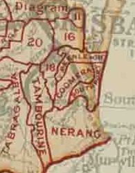
The Shire of Nerang was a local government area in South East Queensland, Australia. The shire existed as a local government entity from 1879 until 1949.
The Shire of Tamborine was a local government area in South East Queensland, Australia, centred on the village of Tamborine. It existed from 1890 to 1949.
The Town of Coolangatta was a local government area in South East Queensland, Australia, centred on Coolangatta. It existed from 1914 to 1949.

The Shire of Brassall is a former local government area in the south-east of Queensland, Australia. It existed from 1879 to 1917.
The Shire of Bundanba is a former local government area in the south-east of Queensland, Australia. It existed from 1879 to 1916.

The Shire of Walloon is a former local government area in the south-east of Queensland, Australia. Its administrative centre was in the town of Marburg.
The Shire of Purga is a former local government area in the south-east of Queensland, Australia.

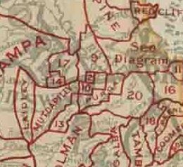
The Shire of Rosewood is a former local government area in the south-east of Queensland, Australia.
The Shire of Lowood is a former local government area in the south-east of Queensland, Australia. It existed between 1912 and 1916.
The Shire of Ipswich is a former local government area in the south-east of Queensland, Australia.

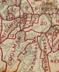
The Shire of Mutdapilly is a former local government area in the south-east of Queensland, Australia. The name comes from the Mutdapilly locality, but the locality was never the administrative centre of the shire.

Mutdapilly is a rural locality in south-east Queensland, Australia. It is split between the local government areas of Scenic Rim Region and City of Ipswich. In the 2021 census, Mutdapilly had a population of 308 people.