
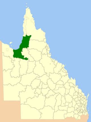
The Kedron Division is a former local government area of Queensland, Australia, located in northern Brisbane.
The Kedron Division is a former local government area of Queensland, Australia, located in northern Brisbane.
Nundah Division was one of the original divisions created on 11 November 1879 under the Divisional Boards Act of 1879 with a population of 4270. [1] [2]
The division was a large one, ranging from the Pine River in the north to the Brisbane River in the south and from Moreton Bay in the east to Chinaman's Creek (now South Pine River) in the west. The residents in the southern part of the division (the Toombul area) felt their needs were quite distinct from those further north and immediately began to agitate for the division to be split. [3] On 1 November 1883, the Toombul Division was separated from the Nundah Division. [4] [5] [6] [7]
In January 1901, Nundah Division was renamed Kedron Division. [2]
On 31 March 2013, the Local Authorities Act 1902 replaced Divisions with Shires and Towns, replacing Kedron Division with Shire of Kedron. [2] [8]

Nundah is an inner suburb in the City of Brisbane, Queensland, Australia. It contains the neighbourhood of Toombul. In the 2021 census, Nundah had a population of 13,098 people.

Shire of Broadsound was a local government area in the Capricornia region of Queensland, Australia. The Shire, administered from the town of St Lawrence, covered an area of 18,546.0 square kilometres (7,160.7 sq mi), and existed as a local government entity from 1879 until 2008, when it was amalgamated with the Shires of Belyando and Nebo to form the Isaac Region.

The Shire of Cloncurry is a local government area in North West Queensland, Australia. It covers an area of 47,971 square kilometres (18,521.7 sq mi), and has existed as a local government entity since 1884. The major town and administrative centre of the shire is Cloncurry.

The Shire of Nebo was a local government area in Central Queensland, Queensland, Australia, about 80 kilometres (50 mi) south-west of the regional city of Mackay. The Shire, administered from the town of Nebo, covered an area of 10,034.6 square kilometres (3,874.4 sq mi), and existed as a local government entity from 1883 until 2008, when it was amalgamated with the Shires of Belyando and Broadsound to form the Isaac Region.
The Shire of Carpentaria is a local government area in Far North Queensland, Australia on the Gulf of Carpentaria, for which it is named.

The Shire of Tiaro was a local government area in the Wide Bay–Burnett region of Queensland, Australia, between the regional cities of Gympie and Hervey Bay about 220 kilometres (137 mi) north of the state capital, Brisbane. The shire covered an area of 2,185.3 square kilometres (843.7 sq mi), and existed as a local government area from 1879 until 2008, when it was dissolved and split between two new local government areas, the Gympie Region and the Fraser Coast Region.

The City of Redcliffe is a former local government area in South East Queensland, Australia. In 2008, it was amalgamated with the Shires of Pine Rivers and Caboolture to create Moreton Bay Region, later renamed City of Moreton Bay. It was in the northern part of the County of Stanley, with a total area of 38.1 square kilometres (14.7 sq mi) and a population of 51,174 people in the 2006 census.
The Shire of Tingalpa was a local government area in the south-eastern suburbs of Brisbane, Queensland, Australia. The shire, administered from Mount Cotton, covered an area of 120 square miles (311 km2), and existed as a local government entity from 1879 until 1949.

The Town of Hamilton is a former local government area of Queensland, Australia, located in north-eastern Brisbane.
The Ithaca Division is a former local government area of Queensland, Australia, located in north-western Brisbane.
The Shire of Kedron is a former local government area of Queensland, Australia, located in northern Brisbane. It existed between 1879 and 1925.

The Shire of Toombul was a local government area of Queensland, Australia, located in northern Brisbane from 1883 to 1925.

The Shire of Moggill is a former local government area of Queensland, Australia, located in western Brisbane.

The Shire of Cleveland is a former local government area in the south-east of Queensland, Australia, centred on the town of Cleveland beside Moreton Bay.

The Shire of Coomera was a local government area in South East Queensland, Australia. The shire, administered from Coomera, existed as a local government entity from 1879 until 1949.

The Shire of Nerang was a local government area in South East Queensland, Australia. The shire existed as a local government entity from 1879 until 1949.

The Town of Southport was a local government area in South East Queensland, Australia.

The Shire of Tinana is a former local government area in the Wide Bay–Burnett area of Queensland, Australia. It is centred on Tinana, on the southern bank of the Mary River, with the Borough of Maryborough on the northern bank. It existed from 1880 to 1917.

The Shire of Granville is a former local government area in the Wide Bay–Burnett area of Queensland, Australia.