
Drayton is a rural locality in the Toowoomba Region, Queensland, Australia. In the 2021 census, Drayton had a population of 1,813 people.

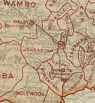
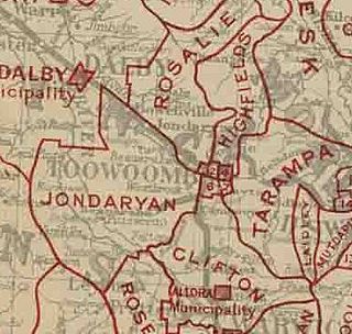
The Shire of Jondaryan was a local government area located in the Darling Downs region of Queensland, Australia, immediately west of the regional city of Toowoomba. The shire, administered from the town of Oakey, covered an area of 1,910.0 square kilometres (737.5 sq mi), and existed as a local government entity from 1890 until 2008, when it amalgamated with several other councils in the Toowoomba area to form the Toowoomba Region. Its growth in later years has been fuelled by the expansion of Toowoomba and suburbs such as Glenvale and Westbrook.

The City of Toowoomba was a local government area in the Darling Downs region of Queensland, Australia, encompassing the centre and inner suburbs of the regional city of Toowoomba. The City covered an area of 116.5 square kilometres (45.0 sq mi), and existed as a local government entity in various forms from 1860 until 2008, when it amalgamated with several other councils in the surrounding area to form the Toowoomba Region.

The Shire of Tiaro was a local government area in the Wide Bay–Burnett region of Queensland, Australia, between the regional cities of Gympie and Hervey Bay about 220 kilometres (137 mi) north of the state capital, Brisbane. The shire covered an area of 2,185.3 square kilometres (843.7 sq mi), and existed as a local government area from 1879 until 2008, when it was dissolved and split between two new local government areas, the Gympie Region and the Fraser Coast Region.
The Shire of Gatton was a local government area located in the Lockyer Valley region between the cities of Toowoomba and Ipswich, and about 90 kilometres (56 mi) west of Brisbane, the state capital of Queensland, Australia. The shire covered an area of 1,571.8 square kilometres (606.9 sq mi), and existed from 1880 until its merger with the Shire of Laidley to form the Lockyer Valley Region on 15 March 2008.

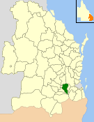
The Shire of Clifton was a local government area in the Darling Downs region of Queensland, Australia, southwest of the regional city of Toowoomba. The shire, administered from the town of Clifton, covered an area of 867.5 square kilometres (334.9 sq mi), and existed as a local government entity from 1879 until 2008, when it amalgamated with several other councils in the Toowoomba area to form the Toowoomba Region.

The Town of Dalby was a local government area of Queensland, Australia which managed the affairs of Dalby. It was located 85 kilometres (53 mi) north-west of Toowoomba. It was amalgamated into the Western Downs Region in 2008.

Harristown is a residential locality in Toowoomba in the Toowoomba Region, Queensland, Australia. In the 2021 census, Harristown had a population of 9,081 people.

Middle Ridge is a residential locality of Toowoomba in the Toowoomba Region, Queensland, Australia. In the 2021 census, Middle Ridge had a population of 7,595 people.

The Shire of Enoggera is a former local government area of Queensland, Australia, located in north-western Brisbane.

The Shire of Toombul was a local government area of Queensland, Australia, located in northern Brisbane from 1883 to 1925.

The Shire of Adavale is a former local government area in the south-east of Queensland, Australia, centred on the town of Adavale. It existed from 1879 to 1930.

The Shire of Nerang was a local government area in South East Queensland, Australia. The shire existed as a local government entity from 1879 until 1949.

The City of Gympie is a former local government area in the south-east of Queensland, Australia, responsible for governing Gympie.
The Shire of Drayton was a local government area in the Darling Downs region of Queensland, Australia, west of Toowoomba. It existed between 1887 and 1949.
The Shire of Gowrie was a local government area in the Darling Downs region of Queensland, Australia.
The Town of Newtown was a local government area in the Darling Downs region of Queensland, Australia, loosely based on the current Newtown, a suburb of Toowoomba. It existed between 1913 and 1917.

The Shire of Tinana is a former local government area in the Wide Bay–Burnett area of Queensland, Australia. It is centred on Tinana, on the southern bank of the Mary River, with the Borough of Maryborough on the northern bank. It existed from 1880 to 1917.
The Town of Cooktown is the former local government area for Cooktown in Far North Queensland, Australia. It existed from 1876 to 1932.

The Shire of Highfields is a former local government area on the Darling Downs in Queensland, Australia. It existed between 1879 and 1949.
