
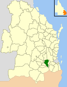
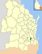
The Town of Laidley is a former local government area comprising the town of Laidley in the Lockyer Valley area between the cities Ipswich and Toowoomba in Queensland, Australia. It existed between 1902 and 1917.
The Town of Laidley is a former local government area comprising the town of Laidley in the Lockyer Valley area between the cities Ipswich and Toowoomba in Queensland, Australia. It existed between 1902 and 1917.
The Tarampa Division was established on 15 January 1880 under the Divisional Boards Act 1879. [1] On 25 April 1888, part of the Tarampa Division was separated to create the Laidley Division. [2]
On 1 July 1902, the Borough of Laidley was established as a municipality for the town of Laidley from part of Subdivision 1 of the Division of Laidley and part of Subdivision 3 of the Division of Tarampa. [3]
With the passage of the Local Authorities Act 1902, on 31 March 1903, the Borough of Laidley and the urban parts of the Division of Laidley became the Town of Laidley, [4] while the rural parts of the Division of Laidley became the Shire of Laidley. [5]
On 8 February 1917, the Town of Laidley was abolished and absorbed into the Shire of Laidley. [5] [6]
The mayors of the Town of Laidley include:

The Shire of Livingstone is a local government area located in the Capricornia region of Central Queensland, Queensland, Australia, to the immediate north and east of the regional city of Rockhampton. The shire, administered from the coastal town of Yeppoon, covers an area of 11,758 square kilometres (4,539.8 sq mi), and existed as a local government entity from 1879 until 2008, when it amalgamated with several other councils to become the Rockhampton Region. The Shire was re-established on 1 January 2014 following a successful de-amalgamation referendum in 2013.

The Shire of Gayndah was a local government area located in the northern catchment of the Burnett River, Queensland, Australia. The shire covered an area of 2,709.3 square kilometres (1,046.1 sq mi), and existed as a local government area from 1866 until 2008, when it amalgamated with several other shires to form the North Burnett Region.
The Shire of Gatton was a local government area located in the Lockyer Valley region between the cities of Toowoomba and Ipswich, and about 90 kilometres (56 mi) west of Brisbane, the state capital of Queensland, Australia. The shire covered an area of 1,571.8 square kilometres (606.9 sq mi), and existed from 1880 until its merger with the Shire of Laidley to form the Lockyer Valley Region on 15 March 2008.
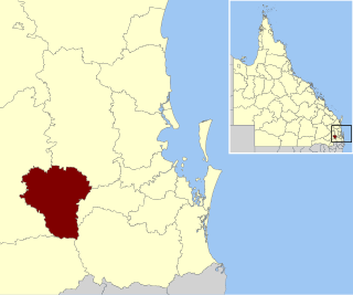
The Shire of Laidley was a local government area located in the Lockyer Valley region between the cities of Toowoomba and Ipswich, and about 70 kilometres (43 mi) west of Brisbane, the state capital of Queensland, Australia. The shire covered an area of 700.6 square kilometres (270.5 sq mi), and existed from 1888 until its merger with the Shire of Gatton to form the Lockyer Valley Region on 15 March 2008.

The City of Bundaberg was a local government area located in the Wide Bay–Burnett region of Queensland, Australia, encompassing the centre and inner suburbs of the regional city of Bundaberg. The city covered an area of 95.5 square kilometres (36.9 sq mi), and existed as a local government entity in various forms from 1881 until 2008, when it amalgamated with several other councils in the surrounding area to form the Bundaberg Region.
The Lockyer Valley Region is a local government area in the West Moreton region of South East Queensland, Australia. It's part of Brisbane. The region is located between the cities of Ipswich and Toowoomba, and is bordered by the Somerset and Southern Downs regions to the north and south, respectively. Lockyer Valley was created in 2008 from a merger of the former shires of Gatton and Laidley. The Lockyer Valley Regional Council has an estimated operating budget of A$35m.
The Shire of Moreton was a local government area in South East Queensland, Australia, located about 50 kilometres (31 mi) southwest of Queensland's capital, Brisbane. It represented an area surrounding but not including Ipswich, and existed from 1917 until 1995, when it merged into the City of Ipswich, City of Brisbane, and Shire of Esk.

The Shire of Mulgrave was a local government area surrounding the City of Cairns in the Far North region of Queensland. The shire, administered from Cairns, covered an area of 1,718.3 square kilometres (663.4 sq mi); it existed as a local government entity from 1879 until 1995, when it was dissolved and amalgamated into the City of Cairns.
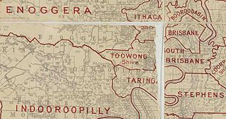
The Town of Toowong is a former local government area of Queensland, Australia, located in western Brisbane in the area around the current suburb of Toowong.

The Shire of Enoggera is a former local government area of Queensland, Australia, located in north-western Brisbane.

The Shire of Moggill is a former local government area of Queensland, Australia, located in western Brisbane.

The Shire of Nerang was a local government area in South East Queensland, Australia. The shire existed as a local government entity from 1879 until 1949.

The City of Gympie is a former local government area in the south-east of Queensland, Australia, responsible for governing Gympie.

The Shire of Tinana is a former local government area in the Wide Bay–Burnett area of Queensland, Australia. It is centred on Tinana, on the southern bank of the Mary River, with the Borough of Maryborough on the northern bank. It existed from 1880 to 1917.
The Town of Cooktown is the former local government area for Cooktown in Far North Queensland, Australia. It existed from 1876 to 1932.

The Shire of Brassall is a former local government area in the south-east of Queensland, Australia. It existed from 1879 to 1917.

The Shire of Walloon is a former local government area in the south-east of Queensland, Australia. Its administrative centre was in the town of Marburg.
The Shire of Lowood is a former local government area in the south-east of Queensland, Australia. It existed between 1912 and 1916.

The Shire of Howard is a former local government area in the Wide Bay–Burnett area of Queensland, Australia, centred on the town of Howard.
The Shire of Widgee is a former local government area in the Wide Bay–Burnett area of Queensland, Australia. It was located in the rural areas around the town of Gympie but did not include the town itself, which was always in a separate local government area. The administrative offices of the Shire of Widgee were located in Gympie.