Related Research Articles

Chillagoe-Mungana Caves is a national park in Chillagoe, Shire of Mareeba, Queensland, Australia.

Chillagoe is a rural town and locality in the Shire of Mareeba, Queensland, Australia. In the 2021 census, the locality of Chillagoe had a population of 214 people.

The Shire of Mareeba is a local government area at the base of Cape York Peninsula in Far North Queensland, inland from Cairns. The shire, administered from the town of Mareeba, covered an area of 53,491 square kilometres (20,653.0 sq mi), and existed as a local government entity from 1879 until 2008, when it amalgamated with several councils in the Atherton Tableland area to become the Tablelands Region.
The Shire of Mundubbera was a local government area in the northern catchment of the Burnett River, Queensland, Australia. The shire covered an area of 4,192.8 square kilometres (1,618.8 sq mi), and existed as a local government area from 1915 until 2008, when it amalgamated with several other shires to form the North Burnett Region.

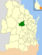
The Shire of Gayndah was a local government area located in the northern catchment of the Burnett River, Queensland, Australia. The shire covered an area of 2,709.3 square kilometres (1,046.1 sq mi), and existed as a local government area from 1866 until 2008, when it amalgamated with several other shires to form the North Burnett Region.

The Shire of Biggenden was a local government area located in the northern catchment of the Burnett River, Queensland, Australia, 100 kilometres (62 mi) south-southwest of the regional city of Bundaberg. The shire covered an area of 1,314.5 square kilometres (507.5 sq mi), and existed as a local government area from 1905 until 2008, when it amalgamated with several other shires to become the North Burnett Region.

The Shire of Tiaro was a local government area in the Wide Bay–Burnett region of Queensland, Australia, between the regional cities of Gympie and Hervey Bay about 220 kilometres (137 mi) north of the state capital, Brisbane. The shire covered an area of 2,185.3 square kilometres (843.7 sq mi), and existed as a local government area from 1879 until 2008, when it was dissolved and split between two new local government areas, the Gympie Region and the Fraser Coast Region.
The Shire of Eacham was a local government area of Queensland. It was located on the Atherton Tableland, a plateau forming part of the Great Dividing Range west of the city of Cairns. The shire, administered from the town of Malanda, covered an area of 1,126.4 square kilometres (434.9 sq mi), and existed as a local government entity from 1910 until 2008, when it amalgamated with several other councils in the Tableland area to become the Tablelands Region.

The Shire of Herberton was a local government area of Queensland. It was located on the Atherton Tableland, a plateau forming part of the Great Dividing Range west of the city of Cairns. The shire, administered from the town of Herberton, covered an area of 9,607.0 square kilometres (3,709.3 sq mi), and existed as a local government entity from 1895 until 2008, when it amalgamated with several other councils in the Tableland area to become the Tablelands Region.

The Shire of Atherton was a local government area of Queensland. It was located on the Atherton Tableland, a plateau forming part of the Great Dividing Range west of the city of Cairns. The shire, administered from the town of Atherton, covered an area of 623.1 square kilometres (240.6 sq mi), and existed as a local government entity from 1881 until 2008, when it amalgamated with several other councils in the Tableland area to become the Tablelands Region.

The Tablelands Region is a local government area in Far North Queensland, Australia inland from the city of Cairns. Established in 2008, it was preceded by four previous local government areas which dated back more than a century. On 1 January 2014, one of those local government areas, the Shire of Mareeba, was re-established independent of the Tablelands Region.

The Shire of Balmoral is a former local government area of Queensland, Australia, located in eastern Brisbane.

The Shire of Adavale is a former local government area in the south-east of Queensland, Australia, centred on the town of Adavale. It existed from 1879 to 1930.
The Shire of Waterford is a former local government area in the south-east of Queensland, Australia, centred on the town of Waterford. It existed between 1879 and 1948.

The Shire of Nerang was a local government area in South East Queensland, Australia. The shire existed as a local government entity from 1879 until 1949.

The Shire of Rosewood is a former local government area in the south-east of Queensland, Australia.
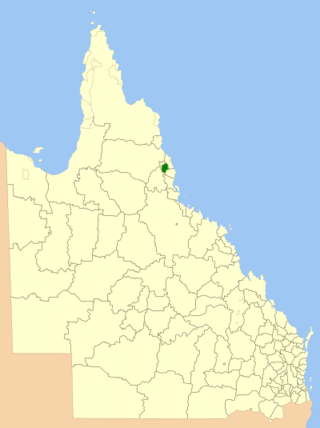
The Shire of Walsh was a local government area in Far North Queensland, Australia, located to the south-west of the town Cairns.

Almaden is a rural town and locality in the Shire of Mareeba, Queensland, Australia. In the 2021 census, the locality of Almaden had a population of 41 people.

Petford is a rural locality in the Shire of Mareeba, Queensland, Australia. In the 2021 census, Petford had a population of 22 people.
References
- ↑ "SHIRE BOUNDARIES". The Brisbane Courier . National Library of Australia. 19 December 1908. p. 10. Retrieved 8 January 2014.
- ↑ "Untitled". Queensland Government Gazette . 23 April 1932. p. 137:1553.
- ↑ "ABOLITION OF SHIRES". The Brisbane Courier . National Library of Australia. 22 April 1932. p. 3. Retrieved 8 January 2014.
- ↑ "Woothakata Shire". Queensland Places. Centre for the Government of Queensland, University of Queensland. Retrieved 15 September 2013.
- ↑ "WOOTHAKATA NOW MAREEBA SHIRE". Townsville Daily Bulletin . Qld.: National Library of Australia. 19 December 1947. p. 5. Retrieved 15 September 2013.
- ↑ "TONGUE-TWISTER CHANGES NAME". The Northern Miner . Charters Towers, Qld.: National Library of Australia. 22 December 1947. p. 1. Retrieved 15 September 2013.
- ↑ Pugh, Theophilus Parsons (1927). Pugh's Almanac for 1927 . Retrieved 13 June 2014.