
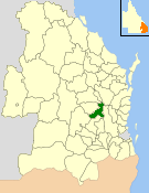
The Shire of Belmont is a former local government area of Queensland, Australia, located in eastern Brisbane including the current suburb of Belmont.
The Shire of Belmont is a former local government area of Queensland, Australia, located in eastern Brisbane including the current suburb of Belmont.

The Bulimba Division was one of the original divisions created on 11 November 1879 under the Divisional Boards Act 1879 with a population of 2007. [1] [2]
On 4 January 1888, the No. 2 subdivision of Bulimba Division was separated to create the new Kianawah Division (later renamed Wynnum Division). [3] [4]
On 19 January 1888, the No. 1 subdivision of Bulimba Division was separated to create Balmoral Division. [5]
On 24 October 1888, the western part of the division was split off to create Shire of Coorparoo. [2]
On 17 March 1892, there was an alteration of boundaries. The Pritchard's Road land and gravel reserve (100 acres) were transferred from Kianawah Division to Balmoral Division. The Grassdale Estate land was transferred from Kianawah Division to Bulimba Division. [6] [7]
On 3 November 1894, the remaining part of Bulimba Division was renamed Belmont Division. [8]
The Local Authorities Act 1902 replaced all Divisions with Towns and Shires, replacing the Belmont Division with the Shire of Belmont on 31 March 1903. [8] [9]
In the belief that the shire was unable to develop properly without a railway service, the shire built its own railway, the Belmont Tramway, which was officially opened on Saturday 25 May 1912. [10]
On 1 October 1925, the shire was amalgamated into the City of Brisbane. [9]

The Shire of Aramac was a local government area located in central Queensland about 1,100 kilometres (684 mi) north west of the state capital, Brisbane, between the towns of Barcaldine and Winton. It covered an area of 23,364.1 square kilometres (9,020.9 sq mi), and existed as a local government entity from 1879 until 2008, when it amalgamated with the Shires of Barcaldine and Jericho to form the Barcaldine Region.
The Shire of Nanango was a local government area located in the South Burnett region of Queensland, Australia, about 100 kilometres (62 mi) northwest of the capital, Brisbane. The Shire covered an area of 1,738.4 square kilometres (671.2 sq mi), and existed as a local government entity from 1879 until 2008, when it amalgamated with several other councils in the South Burnett area to become the South Burnett Regional Council.

Shire of Broadsound was a local government area in the Capricornia region of Queensland, Australia. The Shire, administered from the town of St Lawrence, covered an area of 18,546.0 square kilometres (7,160.7 sq mi), and existed as a local government entity from 1879 until 2008, when it was amalgamated with the Shires of Belyando and Nebo to form the Isaac Region.
The Shire of Yeerongpilly was a local government area in the southern suburbs of Brisbane, Queensland. The shire, administered from Rocklea, covered an area of 175 square miles (453 km2), and existed as a local government entity from 1879 until 1925, when it was split up following the creation of the City of Brisbane under the City of Brisbane Act 1924.
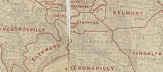
The Shire of Stephens was a local government area in the inner southern suburbs of Brisbane, Queensland, Australia. The shire, administered from Annerley, covered an area of 9 square miles (23 km2), and existed as a local government entity from 1886 until 1925, when it was amalgamated into the City of Brisbane under the City of Brisbane Act 1924.
The Shire of Tingalpa was a local government area in the south-eastern suburbs of Brisbane, Queensland, Australia. The shire, administered from Mount Cotton, covered an area of 120 square miles (311 km2), and existed as a local government entity from 1879 until 1949.
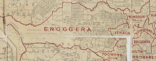
The Ithaca Division is a former local government area of Queensland, Australia, located in north-western Brisbane.
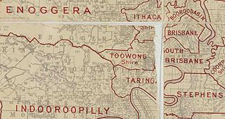
The Town of Toowong is a former local government area of Queensland, Australia, located in western Brisbane in the area around the current suburb of Toowong.

The Town of Wynnum is a former local government area of Queensland, Australia, located in eastern Brisbane adjacent to Moreton Bay around the present day suburb of Wynnum.

The Shire of Balmoral is a former local government area of Queensland, Australia, located in eastern Brisbane.

The Shire of Coorparoo is a former local government area of Queensland, Australia, located in eastern Brisbane.

The Kedron Division is a former local government area of Queensland, Australia, located in northern Brisbane.

The Shire of Toombul was a local government area of Queensland, Australia, located in northern Brisbane from 1883 to 1925.

The Shire of Moggill is a former local government area of Queensland, Australia, located in western Brisbane.

The Shire of Taringa is a former local government area of Queensland, Australia, located in western Brisbane. Its administrative centre was Taringa. It existed from 1890 to 1925.

The Shire of Coomera was a local government area in South East Queensland, Australia. The shire, administered from Coomera, existed as a local government entity from 1879 until 1949.

The Shire of Nerang was a local government area in South East Queensland, Australia. The shire existed as a local government entity from 1879 until 1949.

The Town of Southport was a local government area in South East Queensland, Australia.

The Shire of Highfields is a former local government area on the Darling Downs in Queensland, Australia. It existed between 1879 and 1949.
The Shire of Widgee is a former local government area in the Wide Bay–Burnett area of Queensland, Australia. It was located in the rural areas around the town of Gympie but did not include the town itself, which was always in a separate local government area. The administrative offices of the Shire of Widgee were located in Gympie.