
The Shire of Burdekin is a local government area located in North Queensland, Australia in the Dry Tropics region. The district is located between Townsville and Bowen in the delta of the Burdekin River. The shire covers an area of 5,044 square kilometres (1,947 sq mi). It has existed as a local government entity since 1888. In the 2021 census, the Shire of Burdekin had a population of 16,692 people.

The Shire of Paroo is a local government area in South West Queensland, Australia. The administrative centre is the town of Cunnamulla. The Paroo Shire covers an area of 47,623 square kilometres (18,387 sq mi). In the 2021 census, the Shire of Paroo had a population of 1,679 people.

The City of Mount Isa is a local government area in north west Queensland. The City covers the urban locality of Mount Isa, the administrative centre, and surrounding area, sharing a boundary with the Northern Territory to the west.
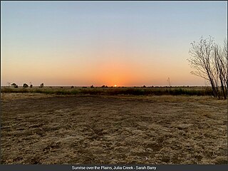
Julia Creek is an outback town and locality in the Shire of Mckinlay, Queensland, Australia. In the 2021 census, the locality of Julia Creek had a population of 549 people.

Richmond is a rural town and locality in the Shire of Richmond, Queensland, Australia. In the 2021 census, the locality of Richmond had a population of 578 people.

The Shire of Winton is a local government area in Central West Queensland, Australia. It covers an area of 53,814 square kilometres (20,777.7 sq mi), and has existed as a local government entity since 1887. Its administrative centre is located in the town of Winton. It is named after Winton, Dorset, England, the birthplace of Robert Allen, the first white settler in the Winton (Queensland) area.

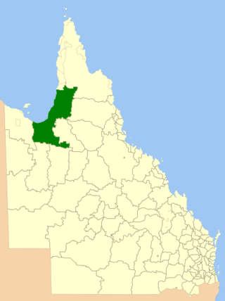
The Shire of Cloncurry is a local government area in North West Queensland, Australia. It covers an area of 47,971 square kilometres (18,521.7 sq mi), and has existed as a local government entity since 1884. The major town and administrative centre of the shire is Cloncurry.

The Shire of Richmond is a local government area in north western Queensland, Australia.

The Shire of Flinders is a local government area in north-western Queensland, Australia.

The Shire of Etheridge is a local government area in Far North Queensland, Australia in what is known as the Savannah Gulf region. Its economy is based on cattle grazing and mining.

The Shire of Croydon is a local government area in western Queensland, Australia. The shire, administered from the town of Croydon, covers an area of 29,498 square kilometres (11,389.2 sq mi). The council consists of a mayor plus four councillors, each of whom represents the entire Shire.
The Shire of Carpentaria is a local government area in Far North Queensland, Australia on the Gulf of Carpentaria, for which it is named.

The Shire of Mornington is a local government area in northwestern Queensland, Australia. The shire covers the Wellesley Islands, which includes Mornington Island; the South Wellesley Islands; Bountiful Islands; and West Wellesley / Forsyth Islands groups in the Gulf of Carpentaria.

The Charters Towers Region is a local government area in North Queensland, Australia southwest of, and inland from the city of Townsville, based in Charters Towers. Established in 2008, it was preceded by two previous local government areas which dated back to the 1870s.
The Southern Downs Region is a local government area in the Darling Downs region of Queensland, Australia, along the state's boundary with New South Wales. It was created in 2008 from a merger of the Shire of Warwick and the Shire of Stanthorpe.

The Aboriginal Shire of Kowanyama is a special local government area which is located on western Cape York Peninsula in Queensland, Australia. It is managed under a Deed of Grant in Trust under the Local Government Act 2004.

The Aboriginal Shire of Pormpuraaw is a special local government area which is located on western Cape York Peninsula in Queensland, Australia. It is managed under a Deed of Grant in Trust under the Local Government Act 2004.

The Aboriginal Shire of Yarrabah is a special local government area in Far North Queensland, Queensland, Australia, east and southeast of Cairns on Cape Grafton. It is managed under a Deed of Grant in Trust under the Local Government Act 2004.
Kynuna is an outback town in the Shire of McKinlay and a locality split between the Shire of McKinlay and the Shire of Winton in Queensland, Australia. In the 2021 census, the locality of Kynuna had a population of 52 people.

McKinlay is an outback town and locality in McKinlay Shire, Queensland, Australia. In the 2021 census, the locality of McKinlay had a population of 162 people.

