
Bulimba Reach is a reach of the Brisbane River in Brisbane, Queensland, Australia. [1]
Bulimba Reach is a reach of the Brisbane River in Brisbane, Queensland, Australia. [1]
Bulimba Reach flows from south (upstream) to north (downstream). The suburbs of Hawthorne and Bulimba are on its eastern bank. The suburbs of New Farm, Teneriffe and Newstead lie to the west. Breakfast Creek joins the Brisbane River from the north-east at the northern end of Bulimba Reach. [2]

The Bulimba Branch railway line was built in 1897 to support the wharves and industries located on the western bank of the Bulimba Reach in Newstead, Teneriffe and New Farm. [3]
Former wharves in the Bulimba Reach include: [4]

There are three ferry terminals on Bulimba Reach (from upstream to downstream):
The CityCat services all of these ferry terminals along the Brisbane River. [5] A cross-river ferry service also operates between Bulimba and Hawthorne ferry wharves. [6]


There are many landmarks along the Bulimba Reach, including (from upstream to downstream):
Historically there were many wharves in the Teneriffe area and there remain a large number of associated warehouses on Macquarie Street which faced the river along the Bulimba Reach. However, urban renewal projects have replaced the wharves with residential apartments and those warehouses are now separated from the river. Similarly on the western bank, the heritage-listed Bulimba House once occupied all the land down to the riverfront at the Bulimba Reach, but subdivision of the estate over the years has resulted in Bulimba House no longer being a riverbank property.

The Brisbane River is the longest river in South East Queensland, Australia, and flows through the city of Brisbane, before emptying into Moreton Bay on the Coral Sea. John Oxley, the first European to explore the river, named it after the Governor of New South Wales, Sir Thomas Brisbane in 1823. The penal colony of Moreton Bay later adopted the same name, eventually becoming the present city of Brisbane. The river is a tidal estuary and the water is brackish from its mouth through the majority of the Brisbane metropolitan area westward to the Mount Crosby Weir. The river is wide and navigable throughout the Brisbane metropolitan area.

Newstead is an inner northern riverside suburb of Brisbane, Queensland, Australia. At the 2021 census, it had a population of 7,496.

Bretts Wharf is a ferry terminal on the northern bank of the Brisbane River in the suburb of Hamilton in the City of Brisbane, Queensland, Australia. It serves patrons from nearby Racecourse Road and Portside Wharf, as well as visitors to Eagle Farm Racecourse and Doomben Racecourse in the Brisbane suburbs of Hamilton and Ascot. Bretts Wharf was the terminus for downstream CityCat services until Apollo Road reopened in February 2008. It is served by RiverCity Ferries' CityCat services.

Bulimba ferry wharf is a heritage-listed ferry wharf at Oxford Street, Bulimba, City of Brisbane, Queensland, Australia. It is located on the southern side of the Brisbane River serving the Brisbane suburb of Bulimba. It is served by RiverCity Ferries' CityCat service and the Cross River service to Teneriffe. It was designed by GHM Addison and Son and built in 1922 by E Taylor. It is also known as Bulimba ferry house and Bulimba waiting shed & landing. It was added to the Queensland Heritage Register on 12 January 2003.

Teneriffe ferry wharf is located on the northern side of the Brisbane River serving the Brisbane suburb of Teneriffe in Queensland, Australia. It is served by RiverCity Ferries' CityCat service and a Cross River service to Bulimba.
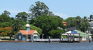
Hawthorne ferry wharf is a heritage-listed ferry wharf located on the southern side of the Brisbane River serving the Brisbane suburb of Hawthorne in Queensland, Australia. It is served by RiverCity Ferries' CityCat services. It was added to the Queensland Heritage Register in 2003.

Holman Street ferry wharf is a heritage-listed ferry wharf located on the southern side of the Brisbane River in Kangaroo Point, City of Brisbane, Queensland, Australia. It is served by RiverCity Ferries' CityHopper and the Cross River service to Riverside wharf. It was added to the Queensland Heritage Register in 2004.

South Bank 1 & 2 ferry wharf is located on the southern side of the Brisbane River serving the Brisbane suburb of South Brisbane in Queensland, Australia. The wharf consists of two jetties, numbered 1 and 2 are used by RiverCity Ferries' CityCat services.

South Bank 3 ferry wharf is located on the southern side of the Brisbane River serving the Brisbane suburb of South Brisbane in Queensland, Australia. It is used by RiverCity Ferries' CityHopper service. South Bank wharves 1 & 2 are located 500 metres upstream.

Transdev Brisbane Ferries, formerly Metrolink Queensland and TransdevTSL Brisbane Ferries, was the operator of the CityCat, CityHopper, and Cross River ferry networks on the Brisbane River in Brisbane, Queensland, Australia from November 2003 until November 2020. The network, operated under contract to the Brisbane City Council, formed part of the TransLink integrated public transport scheme.
Teneriffe is an inner suburb of Brisbane, Queensland, Australia, 2.5 kilometres (1.6 mi) north-east of the CBD. In the 2016 census, Teneriffe had a population of 5,335 people.

Bulimba is a suburb in the City of Brisbane, Queensland, Australia. In the 2016 census, Bulimba had a population of 6,843 people.

Hawthorne is a suburb of the City of Brisbane, Queensland, Australia. In the 2016 census, Hawthorne had a population of 4,989 people.
Bulimba may refer to:

Petrie Bight is a reach of the Brisbane River in Brisbane, Queensland, Australia. The land to the north of the bight, centred on the area under the Story Bridge's northern point and around the Brisbane River to Customs House is also known as Petrie Bight and was formerly a suburb of Brisbane. The area whilst still informally known as Petrie Bight, was absorbed into the suburbs of the Brisbane CBD and Fortitude Valley during consolidation of suburbs by the Brisbane City Council. With a resurgence in Brisbane residents interested in this part of the city and its history, has meant there is a possibility the Brisbane City Council and Queensland Government may once again reinstate Petrie Bight as a suburb to give the area a better sense of identity.

Howard Smith Wharves is a heritage-listed wharf on the Brisbane River at Boundary Street, Brisbane City and Fortitude Valley, City of Brisbane, Queensland, Australia. It was built from c. 1934 to 1940s circa. It is also known as Brisbane Central Wharves. The 3.5-hectare (8.6-acre) site is one of the most culturally and historically significant riverfront locations in Brisbane. It was added to the Queensland Heritage Register on 4 February 1997.
The Bulimba Branch railway line was a branch line off the North Coast railway line in the inner northern suburbs of Brisbane, Australia. It opened on 16 December 1897 to serve the wharves and industries along the western bank of the Bulimba Reach of the Brisbane River at Newstead and Bulimba. Even after the parts of Bulimba on the northern side of the river became the suburbs of Teneriffe and New Farm, it continued to be known as the Bulimba Branch until closure in 1990.
The Woolstore Precinct is a residential area in the suburb of Teneriffe in Brisbane, Australia. A former industrial and commercial area, it has undergone urban renewal with preservation and re-purposing of many buildings from the early 20th century. This renewal has been guided by neighbourhood plans formulated by Brisbane City Council, with advice from the Queensland Heritage Council.

Hamilton Reach is a reach of the Brisbane River in Brisbane, Queensland, Australia.
RiverCity Ferries is a public transport company which commenced operating ferry services in Brisbane on 4 November 2020. It is a subsidiary of the Kelsian Group.
{{citation}}: |author1= has generic name (help) ![]() Media related to Bulimba Reach at Wikimedia Commons
Media related to Bulimba Reach at Wikimedia Commons