Belyando, Queensland

Last updated

Belyando
Queensland
Wide, flat and stark, 180 degree pan looking down the Gregory Developmental Rd, Belyando QLD 4702, not very much going on at all^ Peter Neaum. - panoramio.jpg
View of the Gregory Developmental Road in Belyando, 2015
Australia Queensland location map.svg
Red pog.svg
Belyando
Coordinates 21°51′02″S146°36′22″E / 21.8505°S 146.6061°E / -21.8505; 146.6061 (Belyando (centre of locality))
Population307 (2021 census) [1]
 • Density0.05635/km2 (0.14594/sq mi)
Postcode(s) 4721
Area5,448.3 km2 (2,103.6 sq mi)
Time zone AEST (UTC+10:00)
LGA(s) Isaac Region
State electorate(s) Burdekin
Federal division(s) Capricornia
Suburbs around Belyando:
Llanarth Llanarth Mount Coolon
Pentland Belyando Pasha
Frankfield
Laglan Elgin Elgin

Belyando is a rural locality in the Isaac Region, Queensland, Australia. [2] In the 2021 census, Belyando had a population of 307 people. [1]

Contents

Geography

The Belyando River passes through the locality from south to north, being fed by a number of tributary creeks. The Belyando River feeds into the Suttor River and then into the Burdekin River which flows into the Coral Sea. [3]

The Gregory Developmental Road passes through the locality from the north-east to the south-east; the Bowen Developmental Road enters the locality from the north-east and has its junction with the Gregory Developmental Road in the north-east of the locality. [3] This junction is known as the Belyando Crossing. [4]

The Nairana National Park is in the north-east of the locality and the Wilandspey Conservation Park in the north of the locality. [3]

History

The locality names presumably derives from the Belyando River, where Belyando is believed to an Aboriginal word recorded by explorer and surveyor Thomas Mitchell, where "baal" means "no" and "yan" means "go", spoken by an Aboriginal man trying to stop Mitchell proceeding farther north. [5]

Belyando was also the name associated with the clan that lived near to the Belyando River. [6]

The Yacamunda Station was established by the Earl family and cattle farming is still important for the local area. [6]

Demographics

In the 2016 census Belyando had a population of 66 people. [7]

In the 2021 census, Belyando had a population of 307 people. [1]

Related Research Articles

<span class="mw-page-title-main">Nebo, Queensland</span> Town in Queensland, Australia

Nebo is a rural town and locality in the Isaac Region, Queensland, Australia. In the 2021 census, the locality of Nebo had a population of 857 people.

Buxton is a rural locality in the Bundaberg Region, Queensland, Australia. In the 2021 census, the locality of Buxton had a population of 507 people.

<span class="mw-page-title-main">Belyando River</span> River in Queensland, Australia

The Belyando River, including the Belyando River (Western Branch), is a river system in Central Queensland, Australia. At 1,054 kilometres (655 mi) in length and with a catchment area of 35,000 square kilometres (14,000 sq mi), the Belyando River system is one of the longest rivers in Queensland.

The Suttor River is a river in Central Queensland, Australia. The Belyando River is its main tributary. The river has its origins in the Leichhardt Range, north west of Glenden. It flows into Lake Dalrymple, becoming a tributary of the Burdekin River.

<span class="mw-page-title-main">Corfield, Queensland</span> Town in Queensland, Australia

Corfield is a town and locality in the Shire of Winton in north-western Queensland, Australia. In the 2021 census, the locality of Corfield had a population of 158 people.

Hervey Range is a rural locality split between the City of Townsville and the Charters Towers Region, Queensland, Australia. In the 2021 census, Hervey Range had a population of 295 people.

Minnamoolka is a locality in the Tablelands Region, Queensland, Australia. In the 2021 census, Minnamoolka had a population of 27 people.

<span class="mw-page-title-main">Archer River, Queensland</span> Suburb of Shire of Cook, Queensland, Australia

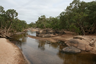
Archer River is a rural locality in the Shire of Cook, Queensland, Australia. In the 2021 census, Archer River had a population of 27 people.

<span class="mw-page-title-main">Bauhinia, Queensland</span> Town in Queensland, Australia

Bauhinia is a rural town in the Central Highlands Region and a rural locality split between the Central Highlands Region and the Aboriginal Shire of Woorabinda, both in Queensland, Australia. In the 2021 census, the locality of Bauhinia had a population of 28 people.

Basalt is a rural locality in the Charters Towers Region, Queensland, Australia. In the 2021 census, Basalt had a population of 215 people.

<span class="mw-page-title-main">Bowen Developmental Road</span> Road in Queensland, Australia

Bowen Developmental Road is a state-controlled district road rated as a local road of regional significance (LRRS). It is a rural strategic main road in Queensland, Australia. It is part of State Route 77, and functions as a highway. It has a length of 259 kilometres (161 mi) and extends in northeast-southwest direction from Bowen on the east coast of Australia to the Gregory Developmental Road in Belyando near Nairana National Park.

Booyal is a town and a locality in the Bundaberg Region, Queensland, Australia. In the 2021 census, the locality of Booyal had a population of 285 people.

Strathfield is a rural locality in the Isaac Region, Queensland, Australia. In the 2021 census, Strathfield had a population of 8 people.

Eaglefield is a locality in the Isaac Region, Queensland, Australia. In the 2021 census, Eaglefield had "no people or a very low population".

Rhydding is a rural locality in the Central Highlands Region, Queensland, Australia. In the 2021 census, Rhydding had a population of 43 people.

Beaufort is a former rural locality in the Barcaldine Region, Queensland, Australia. In the 2016 census, Beaufort had a population of 46 people. On 22 November 2019 the Queensland Government decided to amalgamate the localities in the Barcaldine Region, resulting in five expanded localities based on the larger towns: Alpha, Aramac, Barcaldine, Jericho and Muttaburra. Beaufort was incorporated into Alpha.

Sedgeford is a former rural locality in the Barcaldine Region, Queensland, Australia. In the 2016 census, Sedgeford had a population of 0 people.

Lotus Creek is a rural locality in the Isaac Region, Queensland, Australia. In the 2021 census, Lotus Creek had a population of 113 people.

Frankfield is a rural locality in the Isaac Region, Queensland, Australia. In the 2021 census, Frankfield had a population of 100 people.

Laglan is a rural locality in the Isaac Region, Queensland, Australia. In the 2021 census, Laglan had a population of 21 people.

References

  1. 1 2 3 Australian Bureau of Statistics (28 June 2022). "Belyando (SAL)". 2021 Census QuickStats. Retrieved 28 February 2023. OOjs UI icon edit-ltr-progressive.svg
  2. "Belyando – locality in Isaac Region (entry 47003)". Queensland Place Names. Queensland Government . Retrieved 27 December 2020.
  3. 1 2 3 "Queensland Globe". State of Queensland . Retrieved 25 July 2017.
  4. "Belyando Crossing – unbounded locality in Isaac Region (entry 2245)". Queensland Place Names. Queensland Government . Retrieved 26 July 2017.
  5. "Belyando River – river in the Charters Towers Region (entry 2246)". Queensland Place Names. Queensland Government . Retrieved 26 July 2017.
  6. 1 2 "YACAMUNDA STATION". Central Queensland Herald. 1 August 1935. Retrieved 16 June 2024.
  7. Australian Bureau of Statistics (27 June 2017). "Belyando (SSC)". 2016 Census QuickStats. Retrieved 20 October 2018. OOjs UI icon edit-ltr-progressive.svg

Commons-logo.svg Media related to Belyando, Queensland at Wikimedia Commons