Carmila, Queensland

Last updated

Map all coordinates using: OpenStreetMap  
Download coordinates as: KML
Carmila
Queensland
View across sugar cane fields towards the mountains, Carmila, 2016.jpg
View across sugar cane fields towards the mountains, Carmila, 2016
Australia Queensland location map.svg
Red pog.svg
Carmila
Coordinates 21°54′42″S149°24′37″E / 21.9116°S 149.4102°E / -21.9116; 149.4102 (Carmila (town centre)) Coordinates: 21°54′42″S149°24′37″E / 21.9116°S 149.4102°E / -21.9116; 149.4102 (Carmila (town centre))
Population333 (2016 census locality) [1]
 • Density0.7367/km2 (1.9081/sq mi)
Postcode(s) 4739
Area452.0 km2 (174.5 sq mi)
Time zone AEST (UTC+10:00)
Location
LGA(s) Isaac Region
State electorate(s) Mirani
Federal division(s) Capricornia
Localities around Carmila:
Ilbilbie Ilbilbie The Percy Group
Collaroy Carmila The Percy Group
Collaroy Clairview The Percy Group

Carmila is a rural town and coastal locality in the Isaac Region, Queensland, Australia. [2] [3] In the 2016 census, the locality of Carmila had a population of 333 people. [1]

Contents

Geography

Carmila is situated approximately 65 kilometres (40 mi) south of the town of Sarina.

Being a large locality, there are a number of neighbourhoods within the locality (from north to south):

The North Coast railway line enters the locality from the south (Clairview), passes west of the town, and exits the locality to the north (Ilbilbie). The locality is served by a number of stops (from north to south):

The Bruce Highway passes through the town as well. A large portion of the north west of Carmila belongs to the West Hill State Forest. Along the coast, the West Hill National Park was established in 1971. [11] The major land uses are sugar cane farming and cattle grazing. Professional fishing occurs off the coast. [12]

History

Carmila State School opened on 9 July 1923. [13]

Carmila Post Office opened by March 1924 (a receiving office had been open from 1894). [14]

Carmila West State School opened on 18 August 1924 and closed on 31 December 1965. [13]

West Hill Provisional School opened on 20 May 1925. In 1928, it became West Hill State School. It was mothballed on 31 December 2004 and closed on 24 August 2005. [15] [16] It was at 14 Red Hill Road ( 21°48′36″S149°22′16″E / 21.8099°S 149.3710°E / -21.8099; 149.3710 (West Hill State School) ). [17] [18] [19] [11] The school website has been archived. [20]

Carmila Police Station opened in 1933. [12]

The Carmila Library opened in 1978. [21]

At the 2011 census, Carmila and the surrounding area had a population of 398. [22]

In the 2016 census, the locality of Carmila had a population of 333 people. [1]

Heritage listings

Carmila has a number of heritage-listed sites, including the Carmila Cane Lift at 49 Hindles Road ( 21°55′41″S149°22′06″E / 21.9281°S 149.3682°E / -21.9281; 149.3682 (Carmila Cane Lift) ). [23]

Education

Carmila State School is a government primary (Prep-6) school for boys and girls at Carmila West Road ( 21°54′49″S149°24′13″E / 21.9135°S 149.4035°E / -21.9135; 149.4035 (Carmila State School) ). [24] [25] In 2014, it had 32 students enrolled with 2 teachers (2 full-time equivalent). [26] The nearest secondary school is in Sarina. [11] In 2018, the school had an enrolment of 16 students with 2 teachers and 5 non-teaching staff (3 full-time equivalent). [27]

There are no secondary schools in Carmila. The nearest secondary school is Sarina State High School in Sarina to the north. [11]

Amenities

The Isaac Regional Council operates a public library at 16 Music Street ( 21°54′32″S149°24′41″E / 21.9088°S 149.4114°E / -21.9088; 149.4114 (Carmila public library) ). [28]

St Bartholomew's Anglican Church is at 5 Music Street ( 21°54′30″S149°24′46″E / 21.9084°S 149.4128°E / -21.9084; 149.4128 (St Bartholomew's Anglican Church) ). [29] The Camila Uniting Church meets at the Anglican Church. [30] [31]

St Joseph's Catholic Church is at 12 Music Street ( 21°54′32″S149°24′39″E / 21.9088°S 149.4109°E / -21.9088; 149.4109 (St Joseph's Catholic Church) ). [32]

Related Research Articles

Sarina, Queensland Town in Queensland, Australia

Sarina is a rural town and coastal locality in the Mackay Region, Queensland, Australia. In the 2016 census, Sarina had a population of 5,522 people.

St Lawrence, Queensland Town in Queensland, Australia

St Lawrence is a rural town and locality in the Isaac Region, Queensland, Australia. In the 2016 census the locality of St Lawrence had a population of 235 people.

Bell, Queensland Town in Queensland, Australia

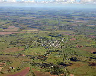
Bell is a rural town and locality in the Western Downs Region, Queensland, Australia. In the 2016 census the locality of Bell had a population of 502 people.

Ravenswood, Queensland Town in Queensland, Australia

Ravenswood is a rural town and locality in the Charters Towers Region, Queensland, Australia. In the 2016 census the locality of Ravenswood had a population of 255 people.

Macalister, Queensland Town in Queensland, Australia

Macalister is a rural town and locality in the Western Downs Region, Queensland, Australia. In the 2016 census the locality of Macalister had a population of 153.

Rollingstone, Queensland Town in Queensland, Australia

Rollingstone is a rural town and coastal locality in the City of Townsville, Queensland, Australia. In the 2016 census, the locality of Rollingstone had a population of 125 people.

Duchess is a rural town and locality in the Shire of Cloncurry, Queensland, Australia. In the 2016 census, Duchess had a population of 23 people.

Koumala is a rural town and coastal locality in the Mackay Region, Queensland, Australia. In the 2016 census, the locality of Koumala had a population of 831 people.

Bouldercombe Town in Queensland, Australia

Bouldercombe is a rural town and locality in the Rockhampton Region, Queensland, Australia. In the 2016 census, the locality of Bouldercombe had a population of 1,085 people.

Alexandra, Queensland Suburb of Mackay, Queensland, Australia

Alexandra is a suburb of Mackay in the Mackay Region, Queensland, Australia. In the 2016 census, Alexandra had a population of 193 people.

Clairview Suburb of Isaac Region, Queensland, Australia

Clairview is a coastal town and locality in the Isaac Region, Queensland, Australia. In the 2016 census the locality of Clairview had a population of 145 people.

Bungeworgorai is a rural locality in the Maranoa Region, Queensland, Australia. In the 2016 census, Bungeworgorai had a population of 78 people.

Hampden is a rural locality in the Mackay Region, Queensland, Australia. In the 2016 census, Hampden had a population of 566 people.

Brookstead, Queensland Town in Queensland, Australia

Brookstead is a rural town and locality in the Toowoomba Region, Queensland, Australia. In the 2016 census, Brookstead had a population of 217 people.

Alloway is a rural locality in the Bundaberg Region, Queensland, Australia. In the 2016 census Alloway had a population of 490 people.

Euthulla is a rural locality in the Maranoa Region, Queensland, Australia. In the 2016 census, Euthulla had a population of 370 people.

Gunnewin is a rural locality in the Maranoa Region, Queensland, Australia. In the 2016 census Gunnewin had a population of 59 people.

Bancroft, Queensland Suburb of North Burnett Region, Queensland, Australia

Bancroft is a rural locality in the North Burnett Region, Queensland, Australia. In the 2016 census Bancroft had a population of 96 people.

Irvingdale is a locality split between the Toowoomba Region and the Western Downs Region, both in Queensland, Australia. In the 2016 census, Irvingdale had a population of 194 people.

References

  1. 1 2 3 Australian Bureau of Statistics (27 June 2017). "Carmila (SSC)". 2016 Census QuickStats. Retrieved 20 October 2018. OOjs UI icon edit-ltr-progressive.svg
  2. "Carmila – town in Isaac Region (entry 6279)". Queensland Place Names. Queensland Government . Retrieved 27 December 2020.
  3. "Carmila – locality in Isaac Region (entry 49756)". Queensland Place Names. Queensland Government . Retrieved 27 December 2020.
  4. "Westhill – locality unbounded in Isaac Regional (entry 39346)". Queensland Place Names. Queensland Government . Retrieved 7 April 2022.
  5. "Tinerta – locality unbounded in Isaac Regional (entry 34627)". Queensland Place Names. Queensland Government . Retrieved 7 March 2022.
  6. "Karloo – locality unbounded in Isaac Regional (entry 17760)". Queensland Place Names. Queensland Government . Retrieved 7 March 2022.
  7. "Carmila West – locality unbounded in Isaac Regional (entry 6282)". Queensland Place Names. Queensland Government . Retrieved 7 March 2022.
  8. "Flaggy Rock Creek – locality unbounded in Isaac Regional (entry 12669)". Queensland Place Names. Queensland Government . Retrieved 7 April 2022.
  9. "Puzzle Pocket – locality unbounded in Isaac Regional (entry 27702)". Queensland Place Names. Queensland Government . Retrieved 7 March 2022.
  10. 1 2 3 4 5 6 "Railway stations and sidings - Queensland". Queensland Open Data. Queensland Government. 2 October 2020. Archived from the original on 5 October 2020. Retrieved 5 October 2020.
  11. 1 2 3 4 "Queensland Globe". State of Queensland . Retrieved 7 April 2022.
  12. 1 2 "Camila Police Station" (PDF). Queensland Police Service. Archived (PDF) from the original on 6 April 2016. Retrieved 29 July 2016.
  13. 1 2 "Opening and closing dates of Queensland Schools". Queensland Government . Retrieved 29 December 2015.
  14. Premier Postal History. "Post Office List". Premier Postal Auctions. Archived from the original on 15 May 2014. Retrieved 10 May 2014.
  15. Queensland Family History Society (2010), Queensland schools past and present (Version 1.01 ed.), Queensland Family History Society, ISBN   978-1-921171-26-0
  16. "Queensland state school - centre closures" (PDF). Queensland Government . 20 August 2013. Archived (PDF) from the original on 20 March 2022. Retrieved 7 April 2022.
  17. "Camila" (Map). Queensland Government. 1943. Archived from the original on 7 April 2022. Retrieved 7 April 2022.
  18. "Parish of West Hill" (Map). Queensland Government. 1977. Archived from the original on 7 April 2022. Retrieved 7 April 2022.
  19. "Parish of Long Hill" (Map). Queensland Government. 1979. Archived from the original on 7 April 2022. Retrieved 7 April 2022.
  20. "West Hill State School". 18 July 2008. Archived from the original on 18 July 2008. Retrieved 7 April 2022.
  21. "Public Libraries Statistical Bulletin 2016-2017" (PDF). Public Libraries Connect. State Library of Queensland. November 2017. p. 13. Archived (PDF) from the original on 30 January 2018. Retrieved 21 January 2018.
  22. Australian Bureau of Statistics (31 October 2012). "Carmila (State Suburb)". 2011 Census QuickStats. Retrieved 14 June 2015. OOjs UI icon edit-ltr-progressive.svg
  23. "Carmila Cane Lift (entry 602751)". Queensland Heritage Register . Queensland Heritage Council. Retrieved 10 July 2013.
  24. "State and non-state school details". Queensland Government. 9 July 2018. Archived from the original on 21 November 2018. Retrieved 21 November 2018.
  25. "Carmila State School". Archived from the original on 26 March 2020. Retrieved 21 November 2018.
  26. "2014 Annual Report" (PDF). Carmila State School. Archived (PDF) from the original on 4 March 2016. Retrieved 29 December 2015.
  27. "ACARA School Profile 2018". Australian Curriculum, Assessment and Reporting Authority. Archived from the original on 27 August 2020. Retrieved 28 January 2020.
  28. "Carmila Library". Public Libraries Connect. State Library of Queensland. 21 June 2017. Archived from the original on 22 January 2018. Retrieved 21 January 2018.
  29. "St Bartholomew's Anglican Church". Churches Australia. Archived from the original on 1 September 2021. Retrieved 1 September 2021.
  30. "Find a Church". Uniting Church in Australia, Queensland Synod. Archived from the original on 24 October 2020. Retrieved 22 November 2020.
  31. "Carmila Uniting Church". Churches Australia. Archived from the original on 1 September 2021. Retrieved 1 September 2021.
  32. "St Joseph's Catholic Church". Churches Australia. Archived from the original on 1 September 2021. Retrieved 1 September 2021.

Further reading