Clairview

Last updated

Map all coordinates using: OpenStreetMap  
Download coordinates as: KML
Clairview
Queensland
Sign about shark sighting on the beach at Clairview, Queensland, 2016.jpg
Shark sighting sign on Clairview's beach, 2016
Australia Queensland location map.svg
Red pog.svg
Clairview
Coordinates 22°07′03″S149°32′05″E / 22.1175°S 149.5347°E / -22.1175; 149.5347 (Clairview (town centre)) Coordinates: 22°07′03″S149°32′05″E / 22.1175°S 149.5347°E / -22.1175; 149.5347 (Clairview (town centre))
Population145 (2016 census) [1]
 • Density0.8319/km2 (2.155/sq mi)
Postcode(s) 4741
Area174.3 km2 (67.3 sq mi)
Time zone AEST (UTC+10:00)
Location
LGA(s) Isaac Region
State electorate(s) Mirani
Federal division(s) Capricornia
Suburbs around Clairview:
Collaroy Carmila The Percy Group
Collaroy Clairview The Percy Group
Collaroy St Lawrence The Percy Group

Clairview is a coastal town and locality in the Isaac Region, Queensland, Australia. [2] [3] In the 2016 census, the locality of Clairview had a population of 145 people. [1]

Contents

Geography

The coastal strip along the east of the locality of Clairview is relatively flat (at or just above sea level), while most of the centre and western part of the locality is hilly, up to 500 meters (1,600 feet). The coastal flats are partially used for grazing, while the hillier land is undeveloped. Clairview has a natural sand beach along the coastline. The town of Clairview is in the south-eastern corner of the locality and consists of a strip of housing on the seafront. [4]

The Bruce Highway (from Brisbane to Cairns) passes through Clairview from the south (the locality of St Lawrence) immediately beside the town of the Clairview and is one of the few places on this "coastal" highway where the sea is actually visible from the road. The highway then continues north on a more inland route into Carmila. The North Coast railway line (also from Brisbane to Cairns) runs just to the east of the highway in the southern town area and then continues north between the highway and the coast, [4] with Elalie railway station ( 22°02′41″S149°29′46″E / 22.0448°S 149.4960°E / -22.0448; 149.4960 (Elalie railway station) ) serving the locality. [5]

In the northernmost part of the locality is the neighbourhood of Flaggy Rock ( 21°58′00″S149°27′00″E / 21.96667°S 149.45000°E / -21.96667; 149.45000 (Flaggy Rock (neighbourhood)) ), which is sandwiched between the highway to the west and the railway line to the east. [4] [6]

History

Remains of the former Clairview railway station on the North Coast railway line, 2016 Remants of the former Clairview railway station, 2016, Queensland.jpg
Remains of the former Clairview railway station on the North Coast railway line, 2016

Clairview takes its name from a former pastoral station operated by W. and M. Christian. [2]

Clairview was served by the Clairview railway station ( 22°07′12″S149°32′06″E / 22.1199°S 149.5350°E / -22.1199; 149.5350 (Clairview railway station (former)) ), [5] but it has been closed. From 20 November 1919, Flaggy Rock was served by Yokolgy or Yankolgy railway station, [7] renamed Flaggy Rock railway station ( 21°58′02″S149°26′42″E / 21.9672°S 149.4449°E / -21.9672; 149.4449 (Flaggy Rock railway station (former)) ) on 4 November 1921 at the request of local residents. [6] [8] It has also closed.

Former Flaggy Rock Creek State School, now Flaggy Rock Community Centre, 2016 Former Flaggy Rock Creek State School, now Flaggy Rock Community Centre, 2016.jpg
Former Flaggy Rock Creek State School, now Flaggy Rock Community Centre, 2016

On 11 October 1916, Rocky Dam State School was opened in Flaggy Rock. It was renamed Flaggy Rock Creek State School in 1920. It was at 85 Flaggy Rock Road ( 21°58′06″S149°26′39″E / 21.9682°S 149.4441°E / -21.9682; 149.4441 (Flaggy Rock Creek State School (former)) ). [9] It closed on 13 December 1996. [10] [11] It is now used as Flaggy Rock Community Centre. [12]

In the 2006 census, the locality of Clairview had a population of 75 people. [13]

In the 2016 census, the locality of Clairview had a population of 145 people. [1]

Education

There are no schools in Clairview. The nearest primary schools are Carmila State School in neighbouring Carmila to the north and St Lawrence State School in neighbouring St Lawrence to the south. The nearest secondary school is Sarina State High School in Sarina to the north, but it is a considerable distance for a daily commute. Distance education and boarding schools are other options. [4]

Attractions

Clairview is popular for fishing and catching mud crabs. The waters off Clairview are a protected area for the endangered dugong. [14]

There is a caravan park and public park. [14]

There is a boat ramp at Colonial Drive across Clairview Beach into the Coral Sea ( 22°07′11″S149°32′10″E / 22.1197°S 149.5362°E / -22.1197; 149.5362 (Colonial Drive boat ramp) ). It is managed by the Isaac Regional Council. [14] [15]

Flaggy Rock Exotic Fruit Garden and Ice-Creamery is at 83978 Bruce Highway ( 21°58′13″S149°26′10″E / 21.9702°S 149.4361°E / -21.9702; 149.4361 (Flaggy Rock Exotic Fruit Garden) ). [16]

Related Research Articles

<span class="mw-page-title-main">Marlborough, Queensland</span> Town in Queensland, Australia

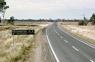
Marlborough is a rural town and coastal locality in the Livingstone Shire, Queensland, Australia. In the 2016 census, the locality of Marlborough had a population of 149 people.

<span class="mw-page-title-main">Wallumbilla, Queensland</span> Town in Queensland, Australia

Wallumbilla is a rural town and locality in the Maranoa Region, Queensland, Australia. In the 2016 census, the locality of Wallumbilla had a population of 388 people, with 191 people living in the town itself.

<span class="mw-page-title-main">St Lawrence, Queensland</span> Town in Queensland, Australia

St Lawrence is a rural town and locality in the Isaac Region, Queensland, Australia. In the 2016 census the locality of St Lawrence had a population of 235 people.

<span class="mw-page-title-main">Carmila, Queensland</span> Town in Queensland, Australia

Carmila is a rural town and coastal locality in the Isaac Region, Queensland, Australia. In the 2016 census, the locality of Carmila had a population of 333 people.

<span class="mw-page-title-main">Shire of Broadsound</span> Local government area in Queensland, Australia

Shire of Broadsound was a local government area in the Capricornia region of Queensland, Australia. The Shire, administered from the town of St Lawrence, covered an area of 18,546.0 square kilometres (7,160.7 sq mi), and existed as a local government entity from 1879 until 2008, when it was amalgamated with the Shires of Belyando and Nebo to form the Isaac Region.

<span class="mw-page-title-main">Yuleba</span> Town in Queensland, Australia

Yuleba is a rural town and locality in the Maranoa Region, in the south-west of Queensland, Australia. In the 2016 census, Yuleba had a population of 207 people.

<span class="mw-page-title-main">Karara, Queensland</span> Town in Queensland, Australia

Karara is a rural town and locality in the Southern Downs Region, Queensland, Australia. In the 2016 census, the locality of Karara had a population of 123 people.

<span class="mw-page-title-main">Dulacca, Queensland</span> Town in Queensland, Australia

Dulacca is a rural town and locality in the Western Downs Region, Queensland, Australia. In the 2016 census the locality of Dulacca had a population of 191 people.

<span class="mw-page-title-main">Dingo, Queensland</span> Town in Queensland, Australia

Dingo is a rural town and locality in the Central Highlands Region, Queensland, Australia. In the 2016 census, the locality of Dingo had a population of 340 people.

Koumala is a rural town and coastal locality in the Mackay Region, Queensland, Australia. In the 2016 census, the locality of Koumala had a population of 831 people.

The Leap is a coastal rural locality in the Mackay Region, Queensland, Australia. In the 2016 census The Leap had a population of 642 people.

<span class="mw-page-title-main">Bouldercombe</span> Town in Queensland, Australia

Bouldercombe is a rural town and locality in the Rockhampton Region, Queensland, Australia. In the 2016 census, the locality of Bouldercombe had a population of 1,085 people.

<span class="mw-page-title-main">East End, Queensland</span> Suburb of Gladstone Region, Queensland, Australia

East End is a rural locality in the Gladstone Region, Queensland, Australia. In the 2016 census, East End had a population of 59 people.

Mistake Creek is a former rural locality in Isaac Region, Queensland, Australia. In the 2016 census, Mistake Creek had a population of 38 people.

<span class="mw-page-title-main">Gogango</span> Town in Queensland, Australia

Gogango is a rural town and locality in the Rockhampton Region, Queensland, Australia. In the 2016 census the locality of Gogango had a population of 111 people.

<span class="mw-page-title-main">Bungunya, Queensland</span> Suburb of Goondiwindi Region, Queensland, Australia

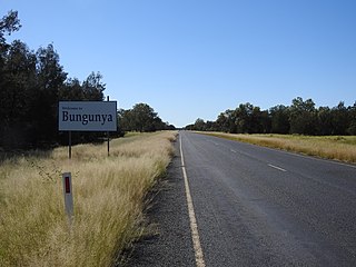
Bungunya is a rural town and locality in the Goondiwindi Region, Queensland, Australia. The locality is on the border of Queensland and New South Wales. In the 2016 census, Bungunya had a population of 75 people.

Chelona is a rural locality in the Mackay Region, Queensland, Australia. In the 2016 census, Chelona had a population of 100 people.

Ilbilbie is a rural town and coastal locality in the Isaac Region, Queensland, Australia. In the 2016 census, the locality of Ilbilbie had a population of 349 people.

Pickanjinnie is a rural locality in the Maranoa Region, Queensland, Australia. In the 2016 census, Pickanjinnie had a population of 49 people.

Kunwarara is a rural locality in the Livingstone Shire, Queensland, Australia. In the 2016 census Kunwarara had a population of 71 people.

References

  1. 1 2 3 Australian Bureau of Statistics (27 June 2017). "Clairview (SSC)". 2016 Census QuickStats. Retrieved 20 October 2018. OOjs UI icon edit-ltr-progressive.svg
  2. 1 2 "Clairview – town in Isaac Region (entry 7258)". Queensland Place Names. Queensland Government . Retrieved 27 December 2020.
  3. "Clairview – locality in Isaac Region (entry 49389)". Queensland Place Names. Queensland Government . Retrieved 27 December 2020.
  4. 1 2 3 4 "Queensland Globe". State of Queensland . Retrieved 2 February 2021.
  5. 1 2 "Railway stations and sidings - Queensland". Queensland Open Data. Queensland Government. 2 October 2020. Archived from the original on 5 October 2020. Retrieved 5 October 2020.
  6. 1 2 "Flaggy Rock (entry 39256)". Queensland Place Names. Queensland Government . Retrieved 29 July 2016.
  7. "St. Andrew's Dinner". The Brisbane Courier . No. 19, 296. Queensland, Australia. 22 November 1919. p. 13. Archived from the original on 2 February 2021. Retrieved 29 July 2016 via National Library of Australia.
  8. "Railway Stations Renamed". The Brisbane Courier . No. 19, 904. Queensland, Australia. 5 November 1921. p. 4. Archived from the original on 2 February 2021. Retrieved 29 July 2016 via National Library of Australia.
  9. "Parish of Porphyry Hill" (Map). Queensland Government. 1977. Archived from the original on 3 May 2022. Retrieved 3 May 2022.
  10. "Agency ID 6637, Flaggy Rock Creek State School". Queensland State Archives . Retrieved 29 July 2016.
  11. "Queensland state school - centre closures" (PDF). Queensland Government . 20 August 2013. Archived (PDF) from the original on 20 March 2022. Retrieved 7 April 2022.
  12. "Flaggy Rock Community Centre". Isaac Regional Council. Archived from the original on 17 August 2016. Retrieved 29 July 2016.
  13. Australian Bureau of Statistics (25 October 2007). "Clairview (SSC)". 2006 Census QuickStats. Retrieved 28 July 2016.
  14. 1 2 3 "Clairview". Tourism and Events Queensland. Queensland Government. Archived from the original on 20 July 2016. Retrieved 29 July 2016.
  15. "Recreational Boating Facilities Queensland". Queensland Open Data. Queensland Government. 12 November 2020. Archived from the original on 22 November 2020. Retrieved 22 November 2020.
  16. "Flaggy Rock". Isaac Regional Council . Archived from the original on 28 October 2020. Retrieved 2 February 2021.

Further reading