Mistake Creek, Queensland

Last updated

Map all coordinates using: OpenStreetMap
Mistake Creek
Queensland
Australia Queensland location map.svg
Red pog.svg
Mistake Creek
Coordinates 22°45′07″S146°55′15″E / 22.7519°S 146.9208°E / -22.7519; 146.9208
Population38 (2016 census) [1]
 • Density0.01311/km2 (0.0339/sq mi)
Area2,899.6 km2 (1,119.5 sq mi)
Time zone AEST (UTC+10:00)
LGA(s) Isaac Region
State electorate(s) Burdekin
Federal division(s) Capricornia
Suburbs around Mistake Creek:
Elgin Frankfield Clermont
Surbiton Mistake Creek Clermont
Surbiton Quetta Peak Vale

Mistake Creek is a former rural locality in Isaac Region, Queensland, Australia. [2] [3] In the 2016 census, Mistake Creek had a population of 38 people. [1]

Contents

On 17 May 2019, it was decided to discontinue the locality and absorb its land into the neighbouring localities of Clermont, Laglan, Frankfield and Peak Vale. [4] [5] [6]

History

The district takes its name from Mistake Creek, a tributary of the Belyando River, which was so named after Jerimiah Rolfe, an early local settler, believed his station to be on that river but later discovered it was on a tributary, which he named Mistake Creek. [7]

Mistake Creek State School opened on 24 January 1983. [8]

Education

Mistake Creek State School is a government primary (Prep-6) school for boys and girls at 6652 Alpha Road ( 22°59′20″S147°05′00″E / 22.9889°S 147.0833°E / -22.9889; 147.0833 (Mistake Creek State School) ). [9] [10] In 2017, the school had an enrolment of 14 students with 2 teachers and 2 non-teaching staff (1 full-time equivalent). [11] Following the absorption of the locality of Mistake Creek into neighbouring localities in May 2019, the school is now within the locality of Clermont. [12]

Amenities

There are other local organisations including Mistake Creek Progress Association and the Mistake Creek Playgroup. [13]

Related Research Articles

<span class="mw-page-title-main">The Gemfields</span> Suburb of Central Highlands Region, Queensland, Australia

The Gemfields is a former locality in the Central Highlands Region, Queensland, Australia. In the 2016 census, The Gemfields had a population of 1,449 people.

<span class="mw-page-title-main">Rubyvale, Queensland</span> Suburb of Central Highlands Region, Queensland, Australia

Rubyvale is a rural town and locality in the Central Highlands Region, Queensland, Australia. In the 2016 census, the town of Rubyvale had a population of 640 people.

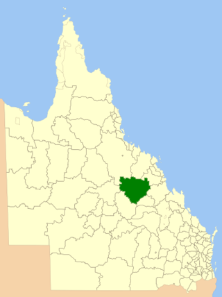
Sapphire Central is a rural locality in the Central Highlands Region, Queensland, Australia. The town of Sapphire is within the locality. Sapphires are mined extensively in the area. At the 2021 census, the locality had a population of 1214 people.

<span class="mw-page-title-main">Central Queensland</span> Region in Queensland, Australia

Central Queensland is an imprecisely-defined geographical division of Queensland that centres on the eastern coast, around the Tropic of Capricorn. Its major regional centre is Rockhampton. The region extends from the Capricorn Coast west to the Central Highlands at Emerald, north to the Mackay Regional Council southern boundary, and south to Gladstone. The region is also known as Capricornia. It is one of Australia's main coal exporting regions.

<span class="mw-page-title-main">Clermont, Queensland</span> Town in Queensland, Australia

Clermont is a rural town and locality in the Isaac Region, Queensland, Australia. At the 2021 census, the locality of Clermont had a population of 2952 people.

<span class="mw-page-title-main">Capella, Queensland</span> Town in Queensland, Australia

Capella is a rural town and locality in the Central Highlands Region, Queensland, Australia. At the 2021 census the locality of Capella had a population of 974 people.

Moranbah is a coal mining town and locality in the Isaac Region, Queensland, Australia. In the 2016 census, the locality of Moranbah had a population of 8,735 people.

Middlemount is a rural town and locality in the Isaac Region, Queensland, Australia. In the 2016 census the locality of Middlemount had a population of 1,841 people.

<span class="mw-page-title-main">Dysart, Queensland</span> Town in Queensland, Australia

Dysart is a town and a locality in the Isaac Region, Queensland, Australia. It is a service centre for mines and grazing properties in the district. At the 2021 census, the locality had a population of 2,918. Most residents are employed by the coal mines.

<span class="mw-page-title-main">Shire of Belyando</span> Local government area in Queensland, Australia

The Shire of Belyando was a local government area in Central Queensland, Australia. The Shire, administered from the town of Clermont, covered an area of 30,281.3 square kilometres (11,691.7 sq mi), and existed as a local government entity from 1879 until 2008, when it was amalgamated with the Shires of Broadsound and Nebo to form the Isaac Region.

<span class="mw-page-title-main">Isaac Region</span> Local government area in Queensland, Australia

The Isaac Region is a local government area located in Central Queensland, Queensland, Australia created in March 2008 as a result of the report of the Local Government Reform Commission released in July 2007.

<span class="mw-page-title-main">Central Highlands Region</span> Local government area in Queensland, Australia

Central Highlands Region is a local government area in Queensland, Australia.

<span class="mw-page-title-main">Argyll, Queensland</span> Suburb of Central Highlands Region, Queensland, Australia

Argyll is a rural locality in the Central Highlands Region, Queensland, Australia. At the 2021 census, Argyll had a population of 25 people,

Dunrobin is a former rural locality in the Barcaldine Region, Queensland, Australia. In the 2016 census, Dunrobin had a population of 14 people.

<span class="mw-page-title-main">Surbiton, Queensland</span> Suburb of Barcaldine Region, Queensland, Australia

Surbiton is a former rural locality in the Barcaldine Region, Queensland, Australia. In the 2016 census, Surbiton had a population of 80 people.

Quetta is a rural locality in the Isaac Region, Queensland, Australia.

Frankfield is a rural locality in the Isaac Region, Queensland, Australia. In the 2021 census, Frankfield had a population of 100 people.

Laglan is a rural locality in the Isaac Region, Queensland, Australia. In the 2016 census Laglan had a population of 3 people, but its boundaries have subsequently changed.

Peak Vale is a rural locality split between the Isaac Region and the Central Highlands Region, Queensland, Australia. In the 2016 census, Peak Vale had a population of 39 people, but its boundaries have been altered subsequently.

Clermont–Alpha Road is a continuous 178 kilometres (111 mi) road route in the Isaac and Barcaldine regions of Queensland, Australia. It is signed as State Route 41 for its entire length. It is a state-controlled regional road, rated as a local road of regional significance (LRRS). It is part of the shortest route from Mackay to Longreach.

References

  1. 1 2 Australian Bureau of Statistics (27 June 2017). "Mistake Creek (SSC)". 2016 Census QuickStats. Retrieved 20 October 2018. OOjs UI icon edit-ltr-progressive.svg
  2. "Mistake Creek (entry 47028)". Queensland Place Names. Queensland Government . Retrieved 13 September 2015.
  3. "Media release". Isac Region. Archived from the original on 9 August 2014. Retrieved 23 July 2014. The Isaac Region ... also includes the smaller communities of Carmila, Clairview, Clarke Creek, Greenhill, Ilbilbie, Kilcummin, Mackenzie River, Mistake Creek and Valkyrie.
  4. "Recent place name decisions". Queensland Government . 14 June 2019. Archived from the original on 7 July 2019. Retrieved 27 October 2019.{{cite web}}: CS1 maint: unfit URL (link)
  5. "Proposed Locality Boundaries and Names of Isaac Regional Council: Clermont, Laglan, Frankfield and Peak Vale, Central Highlands Regional Council: Argyll and Peak Vale" (PDF). Department of Natural Resources, Mines and Energy. Queensland Government. 23 November 2018. Archived (PDF) from the original on 27 October 2019. Retrieved 27 October 2019.
  6. "Locality Boundaries and Names of Isaac Regional Council: Clermont, Laglan, Frankfield and Peak Vale, Central Highlands Regional Council: Argyll and Peak Vale" (PDF). Department of Natural Resources, Mines and Energy. Queensland Government. 17 May 2019. Archived from the original (PDF) on 28 July 2019. Retrieved 27 October 2019.
  7. "Our school: The history behind the name". Mistake Creek State School. Retrieved 23 July 2014.
  8. "Opening and closing dates of Queensland Schools". Queensland Government . Retrieved 18 April 2019.
  9. "State and non-state school details". Queensland Government. 9 July 2018. Archived from the original on 21 November 2018. Retrieved 21 November 2018.
  10. "Mistake Creek State School" . Retrieved 21 November 2018.
  11. "ACARA School Profile 2017". Archived from the original on 22 November 2018. Retrieved 22 November 2018.
  12. "Queensland Globe". State of Queensland . Retrieved 26 October 2019.
  13. "Principal's welcome". Mistake Creek State School. Retrieved 23 July 2014.