Lotus Creek, Queensland

Last updated

Lotus Creek
Queensland
Australia Queensland location map.svg
Red pog.svg
Lotus Creek
Coordinates 22°15′18″S149°03′07″E / 22.255°S 149.0519°E / -22.255; 149.0519 (Lotus Creek (centre of locality))
Population113 (SAL 2021) [1]
Postcode(s) 4705
Area2,542.6 km2 (981.7 sq mi)
Time zone AEST (UTC+10:00)
Location
LGA(s) Isaac Region
State electorate(s)
Federal division(s) Capricornia
Suburbs around Lotus Creek:
Oxford Oxford Collaroy
Valkyrie Lotus Creek Collaroy
May Downs Clarke Creek St Lawrence

Lotus Creek is a rural locality in the Isaac Region, Queensland, Australia. [2] In the 2021 census, Lotus Creek had a population of 113 people. [3]

Contents

Geography

The locality is loosely bounded to the south-west by the Isaac River and to the west by its tributary Connors River and to the north-west by its tributary Funnel Creek. [4]

The Marlborough-Sarina Road enters the locality from the south (Clarkes Creek) and exits to the north (Oxford). [4]

The Tierawoomba State Forest is in the north-east of the locality extending into neighbouring Oxford. Apart from this protected area, the predominant land use is grazing on native vegetation. [4]

History

Baradha (also known as Barada, Toolginburra, Baradaybahrad, Thararraburra, Toolginburra, and Baradha) is an Australian Aboriginal language spoken by the Baradha people. The Baradha language region includes the locality of Lotus Creek and extends along the inland ranges towards Nebo and extends along the Connors River catchment. [5]

The Marlborough-Sarina Road was formerly part of the Bruce Highway. However, it developed a reputation as a "horror road" as it was narrow and winding with creekbed crossings and many vehicles sustained damage. A number of murders of travellers using the road (e.g. the 1975 murders of Noel and Sophia Weckert) caused fear. In 1974, it was decided that a coastal route via Carmila would be developed to eliminate the Malborough-Sarina Road from the Bruce Highway. [6] [7] [8]

Demographics

In the 2016 census, Lotus Creek had a population of 75 people. [9]

In the 2021 census, Lotus Creek had a population of 113 people. [3]

Education

There are no schools in Lotus Creek. The nearest government primary schools are: [10]

However, some parts of Lotus Creek are too distant from these schools for a daily commute and there is no nearby secondary school. The options are distance education and boarding schools. [10]

Related Research Articles

<span class="mw-page-title-main">Sarina, Queensland</span> Town in Queensland, Australia

Sarina is a rural town and coastal locality in the Mackay Region, Queensland, Australia. In the 2021 census, the locality of Sarina had a population of 5,619 people.

<span class="mw-page-title-main">Hay Point, Queensland</span> Town in Queensland, Australia

Hay Point is a coastal locality in Mackay Region, Queensland, Australia. It contains two towns, Hector on its north coast and Half Tide on its south coast. In the 2016 census, Hay Point had a population of 1,348 people.

Clarke Creek is a locality in the Isaac Region, Queensland, Australia. It is situated between Mackay and Rockhampton on the Old Bruce Highway. In the 2021 census, Clarke Creek had a population of 32 people.

<span class="mw-page-title-main">Nebo, Queensland</span> Town in Queensland, Australia

Nebo is a rural town and locality in the Isaac Region, Queensland, Australia. In the 2016 census the locality of Nebo had a population of 753 people.

<span class="mw-page-title-main">England Creek, Queensland</span> Rural locality split between the City of Brisbane and Somerset Region

England Creek is a rural locality split between Somerset Region and City of Brisbane, Queensland, Australia. In the 2016 census, England Creek had a population of 33 people.

Alligator Creek is a coastal rural locality in the Mackay Region, Queensland, Australia. In the 2016 census, Alligator Creek had a population of 791 people.

<span class="mw-page-title-main">Alexandra, Queensland</span> Suburb of Mackay, Queensland, Australia

Alexandra is a suburb of Mackay in the Mackay Region, Queensland, Australia. In the 2016 census, Alexandra had a population of 193 people.

<span class="mw-page-title-main">Clairview</span> Suburb of Isaac Region, Queensland, Australia

Clairview is a coastal town and locality in the Isaac Region, Queensland, Australia. In the 2016 census, the locality of Clairview had a population of 145 people.

Mount Ossa is a rural town and a coastal locality in the Mackay Region, Queensland, Australia. In the 2016 census, the locality of Mount Ossa had a population of 224 people.

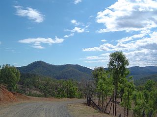
Sarina Range is a rural locality in the Mackay Region, Queensland, Australia. In the 2016 census Sarina Range had a population of 250 people.

<span class="mw-page-title-main">Gowrie Mountain, Queensland</span> Suburb of Toowoomba Region, Queensland, Australia

Gowrie Mountain is a locality in the Toowoomba Region, Queensland, Australia. In the 2021 census, Gowrie Mountain had a population of 222 people.

Armstrong Beach is a coastal town and a locality in the Mackay Region, Queensland, Australia. In the 2016 census, Armstrong Beach had a population of 863 people.

Freshwater Point is a coastal locality in the Mackay Region, Queensland, Australia. In the 2021 census, Freshwater Point had a population of 174 people.

Sarina Beach is a coastal town and locality in the Mackay Region, Queensland, Australia. In the 2016 census, the locality of Sarina Beach had a population of 607 people.

<span class="mw-page-title-main">Grasstree Beach, Queensland</span> Suburb of Mackay Region, Queensland, Australia

Grasstree Beach is a coastal locality in the Mackay Region, Queensland, Australia. It contains two towns, Grasstree in the centre of the locality and Zelma on the coast. In the 2021 census, Grasstree Beach had a population of 717 people.

<span class="mw-page-title-main">Foulden, Queensland</span> Suburb of Mackay, Queensland, Australia

Foulden is a rural locality in the Mackay Region, Queensland, Australia. It is on the northern bank of the Pioneer River in Mackay. In the 2021 census, Foulden had a population of 9 people.

Balberra is a coastal locality in the Mackay Region, Queensland, Australia. In the 2016 census, Balberra had a population of 457 people.

Blue Mountain is a rural locality in the Isaac Region, Queensland, Australia. In the 2021 census, Blue Mountain had a population of 83 people.

Kemmis is a rural locality in the Isaac Region, Queensland, Australia. In the 2021 census, Kemmis had a population of 6 people.

Erakala is a mixed-use locality in the Mackay Region, Queensland, Australia. In the 2021 census, Erakala had a population of 763 people.

References

  1. Australian Bureau of Statistics (28 June 2022). "Lotus Creek (Suburb and Locality)". Australian Census 2021 QuickStats. Retrieved 28 June 2022.  OOjs UI icon edit-ltr-progressive.svg
  2. "Lotus Creek – locality in Isaac Region (entry 47024)". Queensland Place Names. Queensland Government . Retrieved 26 October 2019.
  3. 1 2 Australian Bureau of Statistics (28 June 2022). "Lotus Creek (SAL)". 2021 Census QuickStats. Retrieved 28 February 2023. OOjs UI icon edit-ltr-progressive.svg
  4. 1 2 3 "Queensland Globe". State of Queensland . Retrieved 28 October 2023.
  5. "Baradha". State Library of Queensland . Retrieved 15 January 2020.
  6. Ford, Lyall (24 February 2023). "Inside the mysterious 'Horror Stretch' between Mackay and Rockhampton". Mackay Daily Mercury . Retrieved 29 October 2023.
  7. "Horror Stretch". Queensland Stories. 8 November 2018. Retrieved 28 October 2023.
  8. Patterson, R.; Jones, C.K. (2 August 1974). "Marlborough/Sarina coastal road to be a national highway". Australian Parliament . Retrieved 29 October 2023.
  9. Australian Bureau of Statistics (27 June 2017). "Lotus Creek (SSC)". 2016 Census QuickStats. Retrieved 20 October 2018. OOjs UI icon edit-ltr-progressive.svg
  10. 1 2 "Layers: Locality; Schools and school catchments". Queensland Globe. Queensland Government . Retrieved 28 October 2023.