Kemmis, Queensland

Last updated

Kemmis
Queensland
Australia Queensland location map.svg
Red pog.svg
Kemmis
Coordinates 21°37′26″S148°19′52″E / 21.6238°S 148.3311°E / -21.6238; 148.3311 (Kemmis (centre of locality))
Population0 (2021 census) [1]
 • Density0.0000/km2 (0.0000/sq mi)
Postcode(s) 4742
Area462.1 km2 (178.4 sq mi)
Time zone AEST (UTC+10:00)
Location
LGA(s) Isaac Region
State electorate(s) Burdekin
Federal division(s) Capricornia
Suburbs around Kemmis:
Elphinstone Hail Creek Hail Creek
Burton Kemmis Hail Creek
Burton Coppabella Strathfield

Kemmis is a rural locality in the Isaac Region, Queensland, Australia. [2] In the 2021 census, Kemmis had "no people or a very low population". [1]

Contents

Geography

The land is lower and flatter to the south and east, 260 metres (850 ft) above sea level. [3] However, the terrain becomes more mountainous in the west and north of the locality, [3] with the following peaks (from north to south):

The Suttor Developmental Road enters the locality from the north-east (Hail Creek) and exits to the west (Elphinstone). [3]

The Goonyella railway line enters the locality from the south-west (Strathfield) and exits to the north-west (Hail Creek). [3]

South Walker Creek Mine is a large coal mine in the south of the locality extending into neighbouring Strathfield. [8] There are many other former mine sites in Kemmis. [3]

Apart from mining, the land use is grazing on native vegetation. [3]

History

The locality was named after pastoralist, Arthur Kemmis, who participated in William Landsborough's 1861 expedition from the Gulf of Carpentaria to Melbourne in search of the Burke and Wills expedition. Kemmis was partner in the lease of Fort Cooper pastoral run. [2]

Demographics

In the 2016 census, Kemmis had a population of 3 people. [9]

In the 2021 census, Kemmis had "no people or a very low population". [1]

Education

There are no schools in Kemmis. The nearest government primary schools are Glenden State School in Glenden to the north-west, Nebo State School in Nebo to the east, and Coppabella State School in neighbouring Coppabella to the south. The nearest government secondary school is Glenden State School (to Year 12). [10]

Related Research Articles

<span class="mw-page-title-main">Mount Nebo (Queensland)</span> Suburb of City of Moreton Bay, Queensland, Australia

Mount Nebo is a rural locality in the City of Moreton Bay, Queensland, Australia. In the 2021 census, Mount Nebo had a population of 430 people.

<span class="mw-page-title-main">Mount Glorious</span> Suburb of City of Moreton Bay, Queensland, Australia

Mount Glorious is a rural locality in the City of Moreton Bay, Queensland, Australia. In the 2021 census, Mount Glorious had a population of 343 people.

<span class="mw-page-title-main">Mount Britton, Queensland</span> Suburb of Isaac Region, Queensland, Australia

Mount Britton is a rural locality in the Isaac Region, Queensland, Australia. In the 2021 census, Mount Britton had a population of 4 people. It contains the historic site of the abandoned former gold rush town of Mount Britten in the former Nebo Shire.

<span class="mw-page-title-main">Dysart, Queensland</span> Town in Queensland, Australia

Dysart is a town and rural locality in the Isaac Region, Queensland, Australia. It is a service centre for mines and grazing properties in the district. In the 2021 census, the locality of Dysart had a population of 2,918 people. Most residents are employed by the coal mines.

<span class="mw-page-title-main">Shire of Nebo</span> Local government area in Queensland, Australia

The Shire of Nebo was a local government area in Central Queensland, Queensland, Australia, about 80 kilometres (50 mi) south-west of the regional city of Mackay. The Shire, administered from the town of Nebo, covered an area of 10,034.6 square kilometres (3,874.4 sq mi), and existed as a local government entity from 1883 until 2008, when it was amalgamated with the Shires of Belyando and Broadsound to form the Isaac Region.

<span class="mw-page-title-main">Nebo, Queensland</span> Town in Queensland, Australia

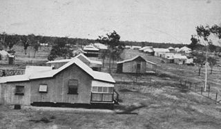
Nebo is a rural town and locality in the Isaac Region, Queensland, Australia. In the 2016 census the locality of Nebo had a population of 753 people.

<span class="mw-page-title-main">Mount Coolon, Queensland</span> Suburb of Whitsunday Region, Queensland, Australia

Mount Coolon is a rural town and locality in the Whitsunday Region, Queensland, Australia. In the 2016 census, the locality of Mount Coolon had a population of 64 people.

<span class="mw-page-title-main">Illinbah, Queensland</span> Suburb of Scenic Rim Region, Queensland, Australia

Illinbah is a rural locality in the Scenic Rim Region, Queensland, Australia. In the 2021 census, Illinbah had a population of 128 people.

Glenden is a mining town and rural locality in the Isaac Region, Queensland, Australia.

<span class="mw-page-title-main">Eungella, Queensland</span> Town in Queensland, Australia

Eungella is a rural town and locality in the Mackay Region, Queensland, Australia. In the 2016 census, Eungella had a population of 194 people.

Hampden is a rural locality in the Mackay Region, Queensland, Australia. In the 2021 census, Hampden had a population of 598 people.

<span class="mw-page-title-main">Carneys Creek, Queensland</span> Rural locality in Queensland, Australia

Carneys Creek is a rural locality in the Scenic Rim Region, Queensland, Australia. It borders New South Wales. In the 2021 census, Carneys Creek had a population of 71 people.

<span class="mw-page-title-main">Moffatdale, Queensland</span> Suburb of South Burnett Region, Queensland, Australia

Moffatdale is a rural locality in the South Burnett Region, Queensland, Australia. In the 2021 census, Moffatdale had a population of 257 people.

<span class="mw-page-title-main">Crediton, Queensland</span> Suburb of Mackay Region, Queensland, Australia

Crediton is a rural locality in the Mackay Region, Queensland, Australia. In the 2021 census, Crediton had a population of 109 people.

<span class="mw-page-title-main">Amamoor Creek, Queensland</span> Suburb of Gympie Region, Queensland, Australia

Amamoor Creek is a rural locality in the Gympie Region, Queensland, Australia. In the 2021 census, Amamoor Creek had a population of 56 people.

Burton is a rural locality in the Isaac Region, Queensland, Australia. In the 2021 census, Burton had a population of 7 people.

<span class="mw-page-title-main">Winchester, Queensland</span> Suburb of Isaac Region, Queensland, Australia

Winchester is a rural locality in the Isaac Region, Queensland, Australia. In the 2021 census, Winchester had a population of 13 people.

Burnett Creek is a rural locality in the Scenic Rim Region, Queensland, Australia. It borders New South Wales to the south. In the 2021 census, Burnett Creek had a population of 16 people.

<span class="mw-page-title-main">Gemini Mountains, Queensland</span> Suburb of Isaac Region, Queensland, Australia

Gemini Mountains is a rural locality in the Isaac Region, Queensland, Australia. In the 2021 census, Gemini Mountains had a population of 65 people.

Lumholtz is a rural locality in the Cassowary Coast Region, Queensland, Australia. In the 2021 census, Lumholtz had "no people or a very low population".

References

  1. 1 2 3 Australian Bureau of Statistics (28 June 2022). "Kemmis (SAL)". 2021 Census QuickStats. Retrieved 28 February 2023. OOjs UI icon edit-ltr-progressive.svg
  2. 1 2 "Kemmis – locality in Isaac Region (entry 47021)". Queensland Place Names. Queensland Government . Retrieved 26 October 2019.
  3. 1 2 3 4 5 6 "Queensland Globe". State of Queensland . Retrieved 30 September 2023.
  4. 1 2 3 "Mountain peaks and capes - Queensland". Queensland Open Data. Queensland Government. 12 November 2020. Archived from the original on 25 November 2020. Retrieved 25 November 2020.
  5. "Mount Lookout – mountain in Isaac Region (entry 20075)". Queensland Place Names. Queensland Government . Retrieved 25 November 2020.
  6. "Mount Hess – mountain in Isaac Region (entry 15818)". Queensland Place Names. Queensland Government . Retrieved 25 November 2020.
  7. "Mount Yuckawaw – mountain in Isaac Region (entry 38768)". Queensland Place Names. Queensland Government . Retrieved 25 November 2020.
  8. "Operations". Stanmore. Archived from the original on 20 September 2023. Retrieved 1 October 2023.
  9. Australian Bureau of Statistics (27 June 2017). "Kemmis (SSC)". 2016 Census QuickStats. Retrieved 20 October 2018. OOjs UI icon edit-ltr-progressive.svg
  10. "Layers: Locality; Schools and school catchments". Queensland Globe. Queensland Government. Archived from the original on 19 December 2017. Retrieved 30 September 2023.