This is a list of schools in the Central Queensland region of Queensland, Australia, and includes schools in Central West Queensland. The region is centred on the coastal cities of Rockhampton and Gladstone, and the inland towns of Emerald, Longreach and Barcaldine. It includes the following local government areas:
Prior to 2015, the Queensland education system consisted of primary schools, which accommodated students from Kindergarten to Year 7 (ages 5–13), and high schools, which accommodate students from Years 8 to 12 (ages 12–18). However, from 2015, Year 7 became the first year of high school. [1]
This includes special schools (schools for disabled children) and schools for specific purposes.
| Name | Suburb | LGA | Opened | Coords | Notes |
|---|---|---|---|---|---|
| Capricornia School of Distance Education | Kawana | Rockhampton | 1993 | 23°20′14″S150°30′53″E / 23.3372°S 150.5148°E | Distance education centre at 241–259 Farm Street, co-located with Glenmore State School and Glenmore State High School. [101] [102] |
| Emerald | Central Highlands | 23°31′56″S148°09′07″E / 23.5323°S 148.1520°E | Distanced education centre at the corner Gray and Gladstone Streets, co-located with Denison State School. [101] [102] | ||
| Longreach School of Distance Education | Longreach | Longreach | 1987 | Distance education centre | |
| Rockhampton North Special School | Frenchville | Rockhampton | 1977 | On site of previous SS | |
| Rockhampton Special School | Rockhampton City | Rockhampton | 1976 | ||
| Rosella Park School | Gladstone | Gladstone | 1971 |
| Name | Suburb | LGA | Opened | Closed | Coords | Notes |
|---|---|---|---|---|---|---|
| Alsace State School | Alsace | Central Highlands | 1977 | 1987 | ||
| Alton Downs State School | Alton Downs | Rockhampton | 1890 | 1964 | 23°18′26″S150°23′13″E / 23.3071°S 150.3869°E | Located at 1247 Ridgelands Road. [103] [104] |
| Arthur's Creek State School | Baffle Creek | Gladstone | c1910 | c1936 | See Baffle Creek State School below | |
| Baffle Creek State School | Baffle Creek | Gladstone | 1955 | 1965 | There was an earlier school known as Baffle Creek State School which changed name to Arthur's Creek State School. It existed from approximately 1910–1936. [105] | |
| Bariveloe State School | Bariveloe (now in Colosseum) | Gladstone | 1927 | 1947 | approx 24°25′28″S151°31′29″E / 24.4244°S 151.5246°E | Located on Bariveloe Road just south of Colosseum Creek. [106] [104] |
| Barmoya East State School | Barmoya | Livingstone | 1911 | 1969 | 23°08′41″S150°32′38″E / 23.14461°S 150.54377°E | Opened 1911 as Barmoya Settlement State School, renamed 1935 Barmoya East State School. [107] Located at 9 C H Barretts Road (corner of East Barmoya Road). [108] |
| Bathampton State School | Bathampton (now in Clermont) | Central Highlands | 1891 | 1950 | [109] | |
| Berajondo State School | Berajondo | Gladstone | 1895 | 1965 | 24°37′39″S151°49′57″E / 24.62758°S 151.83250°E | Opened in 1895 as Milsted Provisional School, became Milstead State School in 1909, renamed Murray's Creek State School in 1911, renamed Berajondo State School in 1931. Located at 173 Dawsons Road. [110] [111] |
| Berserker Street State Infants School | Berserker | Rockhampton | 1957 | 1994 | Merged into Berserker Street State School | |
| Blair Athol State School | Blair Athol | Isaac | 1893 | 1974 | ||
| Bogantungan State School | Bogantungan | Central Highlands | 1883 | 1972 | 23°39′00″S147°17′15″E / 23.6501°S 147.2875°E | Located on the west side of Jackson Street. [112] |
| Bondoola State School | Bondoola | Livingstone | 1887 | 1933 | approx 23°10′29″S150°41′17″E / 23.1746°S 150.6880°E | 1887 opened as Kington Provisional School. 1897 renamed Bondoola Provisional School. It was north of Cobraball Road. [113] |
| 1933 | 1945 | 23°10′29″S150°41′17″E / 23.17460°S 150.68795°E | It was relocated in 1933 to immediately south of the railway station at 54 Bondoola Road. [114] | |||
| Boolburra State School | Boolburra | Central Highlands | 1874 | 1926 | 23°44′06″S149°47′00″E / 23.73487°S 149.78337°E | The school reserve of 6 acres 1 rood 10 perches (2.55 ha) was proclaimed in 1883, just north of the Boolburra railway station bounded by Station Road, Dawson Road, and Thomas Street. [115] [116] [117] |
| Bowman State School | Bowman (now in Ogmore) | Livingstone | 1921 | 1926 | Opened as Styx Coal Mine Provisional School. In 1923 reopened at a new location as Bowman State School. | |
| Bracewell State School | Bracewell | Gladstone | 1915 | 2000 | 23°55′44″S150°53′54″E / 23.9290°S 150.8983°E | Located at 1444 Mount Larcom Bracewell Road. [118] [119] |
| Braeside State School | Braeside (now in Strathfield) | Isaac | 1923 | 1967 | [120] | |
| Buckland State School | Buckland | Central Highlands | 1909 | 1959 | ||
| Bunerba State School | Bunerba (now in Dululu) | Banana | 1922 | 1996 | 23°52′29″S150°17′52″E / 23.8748°S 150.2979°E | Located at 88 Bunerba School Road. [121] [122] |
| Buneru State School | Wowan | Banana | 1918 | 1934 | 23°58′06″S150°09′51″E / 23.96828°S 150.16419°E | Located on the south-western corner of Portion 100 on the (now) Leichhardt Highway. [123] [124] |
| 1934 | 1962 | 23°57′27″S150°08′57″E / 23.9576°S 150.1492°E | Following flooding in 1928, [125] [126] the decision was made to relocate and enlarge the school, [127] [128] at the south-west corner of Buneru Road and Buneru School Road. [129] [130] | |||
| Bungundarra State School | Bungundarra | Livingstone | 1912 | 1950 | approx 23°03′36″S150°39′14″E / 23.06011°S 150.65378°E | Located on the western side of Bungundarra Road. [131] |
| Butlerville State School | Mount Larcom | Gladstone | 1918 | 1927 | 23°45′09″S151°01′57″E / 23.7525°S 151.0324°E | Located on a five-acre (2.0 ha) site on the western side of a bend in The Narrows Road. [132] [133] |
| Callide State School | Callide (now in Jambin) | Banana | 1925 | 1971 | 24°18′04″S150°27′32″E / 24.3012°S 150.4588°E | Located on Callide Road. [134] Although it is within the town of Callide, it is within the present-day boundaries of the neighbouring locality of Jambin. [135] |
| Calliope Station State School | Mount Alma | Gladstone | 1912 | 1956 | 24°01′50″S150°57′45″E / 24.0306°S 150.9624°E | Located at 44 Galloway Plains Road. [136] |
| Calliungal North State School | Baree | Rockhampton | 1904 | 1971 | 23°36′47″S150°23′29″E / 23.6130°S 150.39134°E | Also known unofficially as North Culliungal State School and Baree State School, it opened in April 1904, closing in 1929. In 1933 it reopened, closing finally in 1971. It was at 3–5 Calliungal Road. [137] [138] [139] |
| Calmorin State School | Ridgelands | Rockhampton | 1921 | 1963 | Originally opened as Ridgelands Provisional School, renamed Calmorin State School in 1924. [140] | |
| Calvale State School | Valentine Plains | Banana | 1940 | 1956 | approx 24°22′30″S150°37′42″E / 24.3749°S 150.6284°E | Located on Calvale Road. [141] |
| Cardbeign State School | Cairdbeign | Central Highlands | circa 1894 | circa 1931 | 24°13′32″S148°06′17″E / 24.2255°S 148.1047°E | Located on Dalmally Road. [142] Note the variant spelling. |
| Carmila West State School | Carmila | Isaac | 1924 | 1965 | ||
| Cedar Vale State School | Bracewell | Gladstone | 1926 | 1978 | 23°55′44″S150°53′54″E / 23.9289°S 150.8984°E | Located on a bend in the Mount Larcom Bracewell Road. [143] [144] |
| Clinker Creek State School | Thangool | Banana | 1938 | 1942 | 24°33′46″S150°31′44″E / 24.56267°S 150.52876°E | Located on the south-west corner of Drumburie Road and Frawleys Road. [141] |
| Clio District State School | Clio (now in north-east Kynuna) | Winton | 1969 | 1977 | [145] | |
| Cockatoo Provisional School | Cockatoo | Banana | Prior to 1958 | 1963 | Operated by a governess in a school provided by local parents unil the Queensland Government provided a teacher from 1958. This school closed in 1963. [107] | |
| Cockatoo State School | Cockatoo (now in Bungaban) | Banana / Western Downs | 1984 | 2000 | 25°47′24″S150°15′37″E / 25.7901°S 150.2604°E | Cockatoo State School opened on 23 January 1984 and closed on 31 December 2000. [146] [147] It was located in the south of Cockatoo, now within neighbouring Bungaban at 1473 Ponty Pool Road. [148] |
| Coominglah State School | Lawgi Dawes | Banana | circa 1939 | circa 1947 | 24°42′32″S150°48′39″E / 24.70892°S 150.81085°E | Located on Burns Road. [141] [149] |
| Copperfield State School | Copperfield (now in Clermont) | Isaac | 1875 | 1942 | Copperfield is an abandoned mining town about 4 km south-west of Clermont (town) on Rubyvale Road. [104] | |
| Coreen State School | Orange Creek | Banana | 1933 | 1951 | approx 24°19′55″S150°24′03″E / 24.3319°S 150.4009°E | Located on Prospect Creek Goovigen Road. [150] It takes its name from the local parish name. [151] |
| Corfield State School | Corfield | Winton | 1957 | 1989 | ||
| Cracow State School | Cracow | Banana | 1933 | 1997 | 25°17′36″S150°18′04″E / 25.2933°S 150.3010°E | At 11–17 Third Avenue. [152] [104] |
| Dalma State School | Dalma | Rockhampton | 1901 | 2006 | 23°21′13″S150°14′36″E / 23.3537°S 150.2432°E | Also known as Dalma Scrub State School. Located at 5 Shannen Road. [153] [154] |
| Dalma Road State School | Alton Downs | Rockhampton | 1901 | 1934 | 23°20′43″S150°20′52″E / 23.3454°S 150.3478°E | At 32 Harding Road (north-west corner of Nicholson Road). [155] |
| Dawes State School | Lawgi Dawes | Banana | June 1932 | October 1932 | approx 24°38′50″S150°44′52″E / 24.6473°S 150.7477°E | It was located near the proposed Dawes railway station at the intersection of the Burnett Highway and Blackmans Yard Road. [156] [157] [158] [159] |
| Diamantina State School | Diamantina Lakes | Diamantina | 1955 | 1963 | ||
| Dixalea State School | Dixalea | Banana | 1923 | 1938 | 23°56′45″S150°17′32″E / 23.9457°S 150.2923°E | Opened as Dixie State School, it was renamed Dixalea State School in 1924. [107] Located at approx 120 Dixalea Doreen Road. [160] |
| Don River State School | Dixalea | Banana | 1916 | 1932 | Don River State School opened on 21 August 1916 with an initial enrolment of 50 students. [161] [162] [163] [164] | |
| 1932 | circa 1954 | 23°58′19″S150°18′29″E / 23.9720°S 150.3080°E | It closed on 25 January 1932, but reopened on 18 April 1933 having been relocated to a more central position on Mcdonalds Road. [165] [166] | |||
| circa 1954 | 1964 | approx 23°59′31″S150°18′23″E / 23.9920°S 150.3065°E | It closed again in 1952 and reopened in 1958 before finally closing on 5 June 1964, by which time it had been relocated south of the Don River to Tomlins Road. [107] | |||
| Dululu State School | Dululu | Banana | 1916 | 1968 | 23°50′59″S150°15′40″E / 23.8496°S 150.2612°E | Dululu State School opened circa August 1916 and closed on 11 April 1968. [107] It was at 30 Bryant Street. [167] [168] |
| Earlsfield State School | Earlsfield (now in Jambin) | Banana | 1936 | 1958 | 24°12′19″S150°26′01″E / 24.2052°S 150.4336°E | Opened as Arogoon (also written as Argoon) State School i opened on 30 July 1936, but was renamed Earlsfield State School by October 1936. It closed in 1958. [169] It was on the northern corner of Earlsfield Road and Earlsfield Pit Road. [170] [171] |
| East End State School | East End | Gladstone | 1915 | 1963 | ||
| Edungalba State School | Edungalba (now in Boolburra) | Central Highlands | 1915 | 1974 | approx 23°42′54″S149°51′33″E / 23.71491°S 149.85919°E | Herbert's Creek State School opened on 26 April 1915, but was renamed Edungalba State School in 1918. It closed on 4 February 1974. [107] It was not in the town of Edungalba, but slightly north-west of the town between Herbert Creek and the railway line (approx 23°42′54″S149°51′33″E / 23.71491°S 149.85919°E ). [172] [173] |
| Elphinstone State School | Elphinstone | Isaac | 1880 | 1963 | ||
| Etna Creek State School | Etna Creek | Livingstone | 1892 | circa 1922 | approx 23°13′30″S150°28′51″E / 23.22511°S 150.48075°E | The first school site was on the Yaamba Road near the intersection with the railway line. [174] |
| circa 1922 | 1950 | 23°12′48″S150°25′55″E / 23.21345°S 150.43203°E | The second school site was at 479 Etna Creek Road. [175] [176] | |||
| Evesham State School | Morella (now in Longreach) | Longreach | 1967 | 2009 | The school was on Silsoe Road. The school's website was archived. [177] | |
| Fernlees State School | Fernlees (Gindie) | Central Highlands | 1951 | 1953 | approx 23°50′52″S148°07′17″E / 23.8479°S 148.1214°E | Located on a two-acre (0.81 ha) site off to the west of the Gregory Highway and north of the town. [178] |
| Figton State School | Colosseum | Gladstone | 1904 | 1917 | approx 24°26′56″S151°35′06″E / 24.44889°S 151.58488°E | Mount Pleasant Provisional School opened in 1904, being renamed in the same year Figton Provisional School. On 1 January 1909, it became Figton State School. It closed in 1917. [179] It was in the middle of farmland; today this is just north of the Bruce Highway, but the highway did not exist at that time. [180] |
| Flaggy Rock Creek State School | Flaggy Rock (now in Clairview) | Isaac | 1916 | 1996 | 21°58′06″S149°26′39″E / 21.9682°S 149.4441°E | Opened as Rocky Dam State School. [181] Renamed Flaggy Rock Creek State School in 1920. It was at 85 Flaggy Rock Road. [182] |
| Garnant State School | Garnant | Rockhampton | 1930 | 1969 | 23°11′25″S150°15′34″E / 23.1902°S 150.2595°E | Located on Evans Road. [183] [104] |
| Gregory Mine State School | via Blackwater | Central Highlands | 1978 | 1979 | ||
| Greycliffe State School | Greycliffe (now Orange Creek) | Banana | 1935 | 1993 | 24°15′58″S150°21′22″E / 24.2661°S 150.3562°E | Located on the corner of Belldeen Greycliffe Road and Prospect Creek Goovigen Road, now within the boundaries of Orange Creek. [184] |
| Hamilton Creek State School | Hamilton Creek | Rockhampton | 1908 | 1972 | 23°40′29″S150°24′03″E / 23.6746°S 150.4008°E | Located at 50536 Burnett Highway (opposite Golf Links Road). [185] [186] [187] |
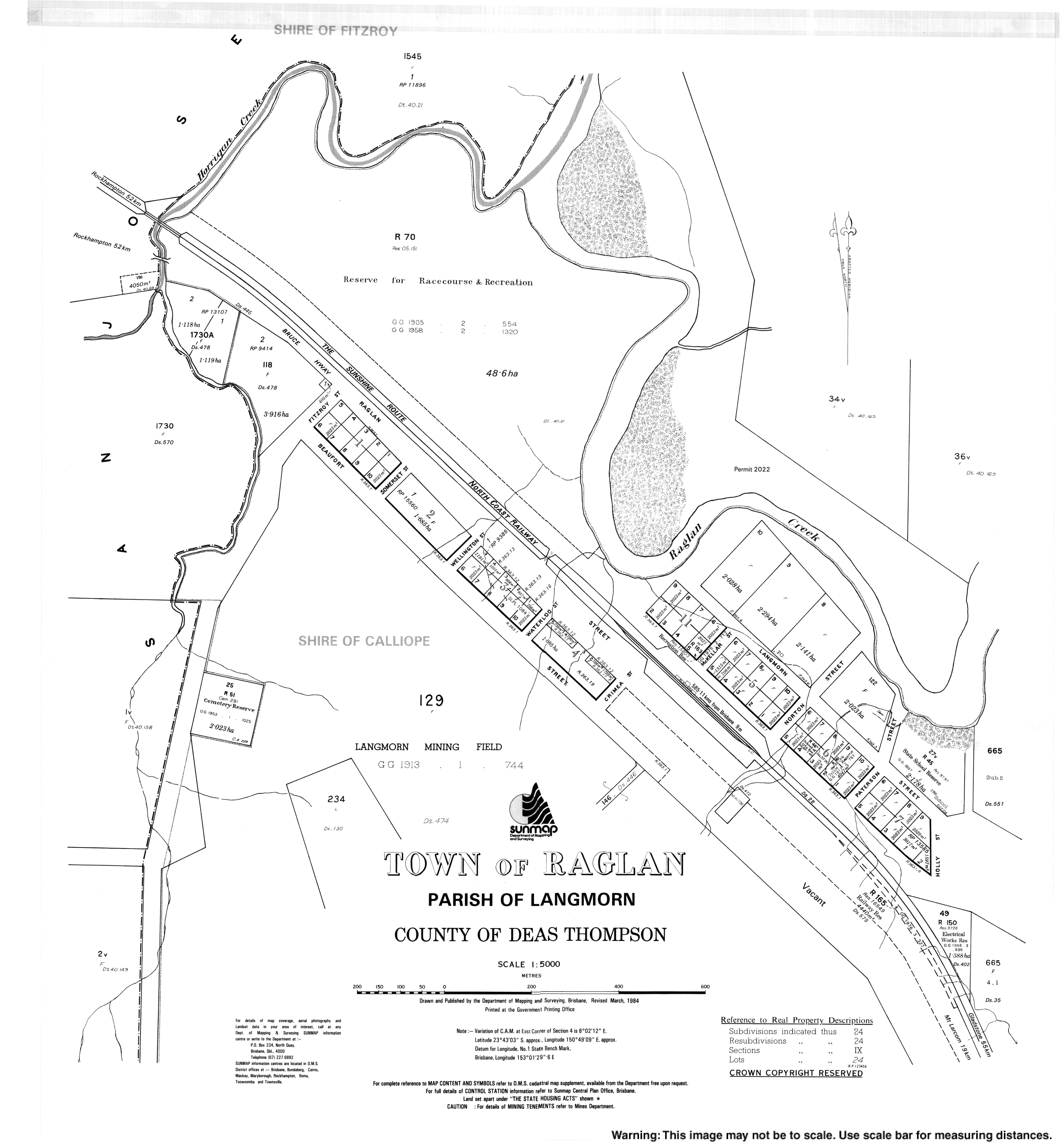
| Hourigan Creek State School | Raglan | Gladstone | 1916 | circa 1932 | approx 23°44′16″S150°46′58″E / 23.7378°S 150.7829°E | Located on or near Hourigan Creek Road. [188] [104] |
| Hut Creek State School | Ambrose | Gladstone | 1921 | 1945 | approx 23°50′52″S150°53′55″E / 23.8477°S 150.8985°E | Located on Hut Creek Road. [189] [190] |
| Ilbilbie State School | Ilbilbie | Isaac | 1930 | 1960 | 21°42′54″S149°21′46″E / 21.7151°S 149.3628°E | Located at approx 87133 Bruce Highway. [191] [192] |
| Jooro State School | Jooro (now in Goovigen) | Banana | 1935 | 1963 | 24°06′38″S150°11′20″E / 24.1105°S 150.1888°E | Located on a five-acre (2.0 ha) site on the east of Claire Lane. [129] [193] |
| Joskeleigh State School | Joskeleigh | Livingstone | 1913 | 1985 | 23°22′03″S150°46′58″E / 23.3676°S 150.7829°E | Located at 356 Joskeleigh Road. [194] [195] |
| Kalapa State School | Kalapa | Rockhampton | 1915 | 1996 | 23°30′38″S150°16′06″E / 23.5105°S 150.2682°E | Located at 22 Kalapa Black Mountain Road. [196] |
| Kariboe Creek State School | Thangool | Banana | 1930 | 1963 | 24°27′47″S150°31′22″E / 24.4631°S 150.5229°E | There was an earlier Kariboe Creek Provision School from 1925 to 1926. Kariboe Creek State School was located at 1 Mullers Lane. [141] [197] |
| Katherine Creek State School | Katherine Creek (now in Maneroo) | Longreach | 1968 | 1979 | [198] | |
| Kokotungo State School | Kokotungo | Banana | 1939 | 1969 | ||
| Konara State School | Konara (now Oakey Creek) | Rockhampton | 1919 | 1927 | approx 23°45′48″S150°21′36″E / 23.7633°S 150.36009°E | Located north of the Konara railway station, between the railway line and the Dee River, just south of the confluence with Fletcher Creek (approx 23°45′48″S150°21′36″E / 23.7633°S 150.36009°E ), now in Oakey Creek. [199] [200] |
| Kooingal State School | Kooingal (now in Prospect) | Banana | 1931 | 1956 | 24°31′43″S150°25′38″E / 24.5287°S 150.4271°E | Located at 1382 Crowsdale Camboon Road. [141] |
| Kroombit Provisional School | Thangool | Banana | 1933 | 1936 | [201] | |
| Laidlaw State School | via Longreach | Longreach | 1967 | 1971 | [140] | |
| Lake Pleasant State School | Goovigen | Banana | 1925 | 1964 | 24°05′55″S150°18′02″E / 24.09850°S 150.30060°E | Located at 470 Lake Pleasant Road north of the town of Goovigen. [202] |
| Langmorn State School | Ambrose | Gladstone | 1928 | 1962 | 23°49′07″S150°52′56″E / 23.8185°S 150.8823°E | Located at 187 Langmorn School Road. [203] [204] |
| Laurinel State School | Mount Gardiner | Central Highlands | 1983 | 1987 | [205] | |
| Leichhardt Ward Boys State School | Rockhampton City | Rockhampton | 1905 | 1986 | Merged with The Hall Girls' & Infants' School | |
| Machine Creek State School | Machine Creek | Gladstone | 1911 | 1970 | 23°50′16″S150°56′16″E / 23.8378°S 150.9377°E | Located at 540 Mount Larcom Bracewell Road (north-west corner of Ambrose Bracewell Road). [206] [207] The school building was later relocated to the Calliope River Historical Village at River Ranch. [208] |
| Mackenzie River State School | Mackenzie River | Isaac | 1973 | 2018 | 22°57′01″S148°55′43″E / 22.9503°S 148.9287°E | Mackenzie River State School opened on 21 May 1973, but closed in 2018 after having no students enrol in 2017. [107] [209] [210] It was at 31145 Fitzroy Developmental Road. The school's website was archived. [211] |
| Mahrigong State School | Corfield | Winton | 1966 | 1981 | Mahrigong is a sheep station 56 miles East from Winton. [212] | |
| Maida Hill State School | Maida Hill (now in Opalton) | Winton | 1878 | 1913 | [213] | |
| Malakoff Road State School | Theodore | Banana | 1913 | 1965 | ||
| Many Peaks State School | Many Peaks | Gladstone | 1909 | 1973 | 24°32′41″S151°22′22″E / 24.5446°S 151.3727°E | Opened 1909 as Nanandu Provisional School, renamed 1909 Many Peaks State School. [214] Located at 5 Wentworth Street. [215] [216] |
| Mardale State School | Lawgi Dawes | Banana | 1935 | 1964 | Lawgi SS until 1952 | |
| Miclere Provisional School | Kilcummin | Isaac | 1941 | 1954 | Was closed between 6 June 1943 and 24 August 1947. Miclere is now in Kilcummin. [217] [218] | |
| Middlemount State High School | Middlemount | Isaac | 1988 | 2000 | Amalgamated into Middlemount Community School | |
| Middlemount State School | Middlemount | Isaac | 1980 | 2000 | Amalgamated into Middlemount Community School | |
| Morinish Provisional School | Morinish | Rockhampton | circa 1882 | circa 1890 | It is not clear if this was the same school closing and reopening or two different schools with the same name. | |
| circa 1894 | circa 1897 | |||||
| Morinish State School | Morinish | Rockhampton | 1902 | 1928 | approx 23°15′04″S150°09′24″E / 23.2512°S 150.1566°E | Opened as Morinish No 1 Provisional School, becoming Morinish State School in 1915. It closed in 1928. It was on Morinish Road. [219] In 1930, the school building was relocated to establish Garnant State School. |
| Morinish No 2 Provisional School | Morinish | Rockhampton | 1902 | 1915 | ||
| Mount Chalmers State School | Mount Chalmers | Livingstone | 1901 | 2005 | 23°17′56″S150°38′27″E / 23.2989°S 150.6409°E | Located at 16 School Street. [220] [221] |
| Mount Scoria State School | Mount Scoria (Thangool) | Banana | 1930 | 1958 | approx 24°31′59″S150°36′59″E / 24.5330°S 150.6164°E | Located to the immediate north-east of the Mount Scoria railway station. [156] |
| Nerimbera State School | Nerimbera | Livingstone | 1921 | 2009 | 23°24′02″S150°35′20″E / 23.4006°S 150.5888°E | Located at 4 Graff Road on the corner Nerimbera School Road. [220] [222] |
| Ogmore State School | Ogmore | Livingstone | 1924 | 1999 | 22°37′21″S149°39′39″E / 22.6225°S 149.6609°E | Opened as Hartley Provisional School, 1933 renamed Ogmore. [44] Located at 2–4 Wilangi Street. [223] [224] [225] |
| Oyster Creek State School | Oyster Creek | Gladstone | 1913 | circa 1943 | approx 24°26′38″S151°51′04″E / 24.4440°S 151.85119°E | On the western side of Oyster Creek Road. [226] [227] |
| Pasha State School | Pasha | Central Highlands | 1975 | 1977 | ||
| Peek-A-Doo State School | Eurombah | Banana | 1964 | 2010 | 25°54′29″S149°29′58″E / 25.9081°S 149.4995°E | Located at 10118 Roma Taroom Road. [228] The school's website was archived. [229] |
| Pheasant Creek State School | Pheasant Creek | Banana | circa 1919 | circa 1921 | Pheasant Creek Provisional School opened circa 1919, but closed circa 1921. It was a tent school, which was relocated to Benarabin. [230] | |
| 1925 | 1928 | After much local lobbying, [230] [231] [232] [233] [234] [235] [236] [237] [238] [239] in 1925, a new school building was erected and opened as Pheasant Creek State School, [240] [241] but it had closed by 1928 with the building proposed to be relocated to Biloela. [242] [243] [244] [245] | ||||
| 1940 | 1967 | 23°49′08″S150°04′09″E / 23.81876°S 150.06903°E | Lobbying for a school resumed in 1936. [246] [247] [248] In April 1940, tenders were called for a new school building (possibly funded by the local community), [249] [250] which opened on 29 October 1940. It closed permanently in 1967. [107] It was on the western side of Grantleigh Pheasant Creek Road. [251] [252] | |||
| Pink Lily Lagoon State School | Pink Lily | Rockhampton | 1872 | 1971 | 23°21′27″S150°28′13″E / 23.3576°S 150.4704°E | Located at 17 Six Mile Road. [253] |
| Playfair State | Bushley | Rockhampton | 1917 | 1928 | 23°32′11″S150°15′58″E / 23.5364°S 150.2661°E | The school was located at approximately 213 Sandy Creek Road. [254] |
| Polmaily State School | Colosseum | Gladstone | 1900 | 1935 | 24°23′19″S151°31′20″E / 24.3885°S 151.5221°E | Polmaily State School was at 664 Blackmans Gap Road, Colosseum. [255] |
| Raedon State School | Biloela | Banana | 1929 | 1959 | 24°21′58″S150°29′55″E / 24.3662°S 150.4985°E | Originally Callide Bridge SS and briefly renamed Melton and Raeworth before becoming Raedon. [256] Located at 11 Teys Road, [257] now within Biloela but on the locality boundary with Dakenba. [258] |
| Raglan State School | Raglan | Gladstone | 1879 | 1996 | 23°43′11″S150°49′25″E / 23.7196°S 150.8237°E | Located at 18 Langmorn Street. [259] [104] |
| Rannes State School | Rannes | Banana | 1916 | 1966 | approx 24°06′07″S150°07′21″E / 24.10208°S 150.12252°E | Located on the northern side of Goovigen Rannes Road and the railway line. [260] |
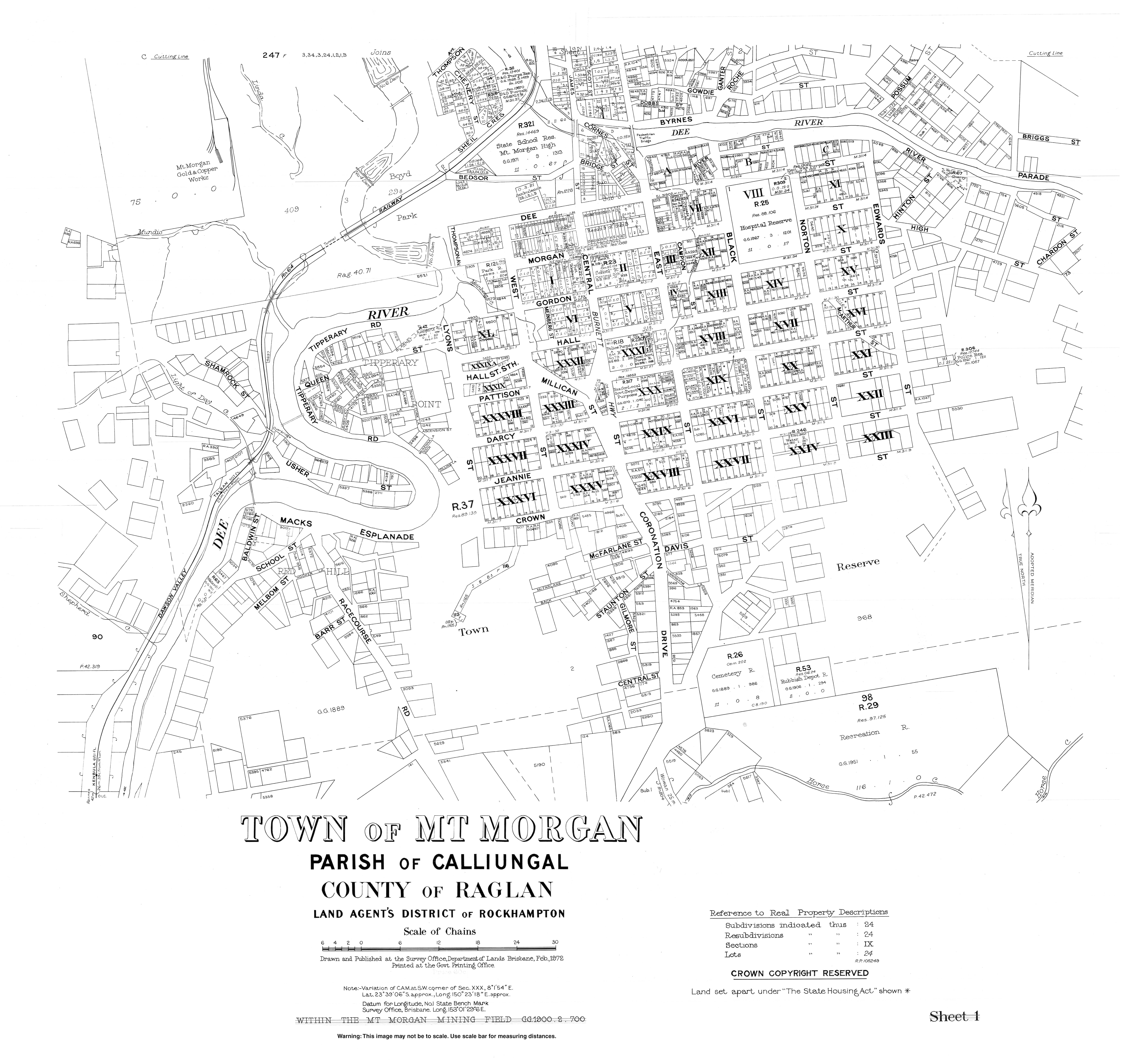
| Red Hill State School | Mount Morgan | Rockhampton | 1900 | circa 1931 | approx 23°39′10″S150°22′33″E / 23.6529°S 150.3758°E | Located in the Red Hill neighbourhood of Mount Morgan and is presumably the origin of the name of School Street. [261] [262] |
| Riverston State School | Taragoola | Gladstone | circa 1936 | 1960 | Coordinates for Riverston are within Lake Awoonga so may have been inundated by the construction of the dam [263] | |
| Rockhampton Central Boys' State School | Rockhampton City | Rockhampton | 1862 | 1963 | ||
| Rockhampton Central Girls' State School | Rockhampton City | Rockhampton | 1875 | 1973 | ||
| Rockhampton Central Infants School | Rockhampton City | Rockhampton | 1876 | 1962 | Merged into Girls' School | |
| Rockhampton North State School | Frenchville | Rockhampton | 1871 | 1966 | Split sex 1888–1920 | |
| Rocky Crossing State School | Jundah | Barcoo | 1988 | 2003 | [264] | |
| Rossmoya State School | Rossmoya | Livingstone | 1923 | 1968 | 23°01′32″S150°29′03″E / 23.02557°S 150.48425°E | Located at 1770 Rossmoya Road. [265] |
| Rubyvale State School | Rubyvale | Central Highlands | 1908 | 1963 | ||
| Sapphire State School | Sapphire | Central Highlands | 1904 | 1939 | ||
| Sleipner Junction Provisional School | Nankin | Livingstone | 1913 | 1923 | ||
| Spring Creek State School | Spring Creek | Banana | 1871 | 1954 | ||
| Spring Creek Upper State School | Spring Creek Upper | Banana | 1915 | 1970 | ||
| Struck Oil State School | Struck Oil | Rockhampton | 1905 | 1944 | approx 23°36′44″S150°27′04″E / 23.61226°S 150.45112°E | Located on the south side of Struck Oil Road. [266] |
| Styx River State School | Styx (now in Ogmore) | Livingstone | 1919 | 1942 | 22°35′30″S149°38′01″E / 22.5916°S 149.6337°E | Located on Styx Road near the railway station. [223] [224] |
| Surprise Creek State School | now in Opalton | Winton | circa 1902 | circa 1908 | [267] | |
| Tableland Provisional School | Tablelands | Gladstone | 1905 | c. 1916 | approx 24°17′29″S150°57′03″E / 24.29139°S 150.95093°E | Located on Tableland Road. [268] |
| Targinnie State School | Targinnie | Gladstone | 1923 | 1968 | ||
| Ten Mile Creek Provisional School | Morinish | Rockhampton | 1916 | circa 1917 | ||
| Thompson's Point State School | Thompsons Point | Livingstone | 1906 | 1929 | ||
| Tiamby Provisional School | Thangool | Banana | 1933 | 1942 | 24°40′53″S150°28′26″E / 24.6813°S 150.4738°E | Located on the north-eastern corner of 3224 Crowsdale Camboon Road. [141] [269] |
| Turkey Road State School | Bororen | Gladstone | 1921 | 1931 | approx 24°13′05″S151°31′50″E / 24.2181°S 151.5305°E | Located on Bates Road. [270] |
| Turnorville Provisional School | Mackay or Sarina area? | 1960 | 1962 | |||
| Ulam South State School | via Bajool | Rockhampton | 1894 | 1925 | 23°45′58″S150°37′59″E / 23.76616°S 150.63318°E | Located on a 5-acre (2.0 ha) site at 1385 South Ulam Road near the junction with Comerford Road. [271] [272] |
| Ulam Upper State School | via Bajool | Rockhampton | circa 1892 | circa 1961 | ||
| Valentine Plains State School | Valentine Plains | Banana | 1928 | 1967 | 24°25′10″S150°34′46″E / 24.4195°S 150.5795°E | Located on Valentine Plains Road. [141] |
| Wallaroo Provisional School | Wallaroo | Central Highlands | circa 1898 | 1909 | [107] [273] | |
| Walterhall State School | Walterhall | Rockhampton | 1917 | 1969 | [274] | |
| Wartburg State School | Wartburg | Gladstone | 1913 | 1966 | ||
| Wattlebank State School | Barmoya? | Livingstone | 1918 | 1933 | Barmoya Central State School opened on 28 August 1918. [275] In February 1930, the school was closed because it had only seven students; it was suggested that the school should be moved to a more central location. [276] In October 1931, it was proposed to relocate the school building to Rossmoya Road where 16 students could attend the school, [277] [278] but some parents thought it was too distant for their children to travel to and from the school each day. [279] [280] In June 1932, it was decided to move the school to Rossmoya Road, [281] but, in March 1933, the government said there were insufficient funds available to move the school at that time. [282] | |
| Wattlebank | 1934 | 1959 | 23°07′49″S150°27′34″E / 23.13030°S 150.45931°E | In September 1933, tenders were called to relocate the school. [283] The school was relocated in January 1934. [284] In 1936, it was renamed Wattlebank State School. [285] It closed in December 1959. [286] It was on the western side of Rossmoya Road in Wattlebank. [287] [288] | ||
| West Hill State School | Carmila | Isaac | 1925 | 2004 | 21°48′36″S149°22′16″E / 21.8099°S 149.3710°E | West Hill is an unbounded locality in the north of the locality of Carmila. [289] Located at 14 Red Hill Road. [290] [291] [292] The school website was archived. [293] |
| Withersfield State School | Withersfield (now within Willows) | Central Highlands | 1920 | circa 1942 | approx 23°34′33″S147°33′51″E / 23.5757°S 147.5643°E | Located north of the former town of Withersfield on a five-acre-two-rood-eleven-perch (2.25 ha) site. [294] [295] |
| Woodbury Provisional School | Woodbury | Livingstone | 1923 | 1925 | ||
| Wooderson State School | Wooderson | Gladstone | 1945 | 1960 | 24°07′13″S151°04′47″E / 24.1204°S 151.0796°E | Located on a 4-acre-32-perch (1.70 ha) site at 306 Wooderson Road. [296] [297] |
| Woolein State School | Woolein | Banana | 1918 | 1924 | ||
| Wura State School | Wura | Rockhampton | 1924 | circa 1944 | approx 23°48′58″S150°19′38″E / 23.8160°S 150.3273°E | Located between the Wuru railway station and the Dee River. [199] |
| Wycarbah State School | Wycarbah | Rockhampton | 1876 | circa 1935 | 23°32′40″S150°12′46″E / 23.54446°S 150.21271°E | Rosewood Crossing Provisional School opened on 31 July 1876. In 1892, it was renamed Wycarbah Provisional School. On 1 January 1909, it became Wycarbah State School. It closed circa 1935. [107] It was at 14 Wycarbah Road. [298] |
| Yaamba State School | Yaamba | Livingstone | 1867 | 1940 | approx 23°07′58″S150°22′01″E / 23.1328°S 150.3670°E | Located on the north-west corner of Iris Street and Yaamba Siding Road. [299] |
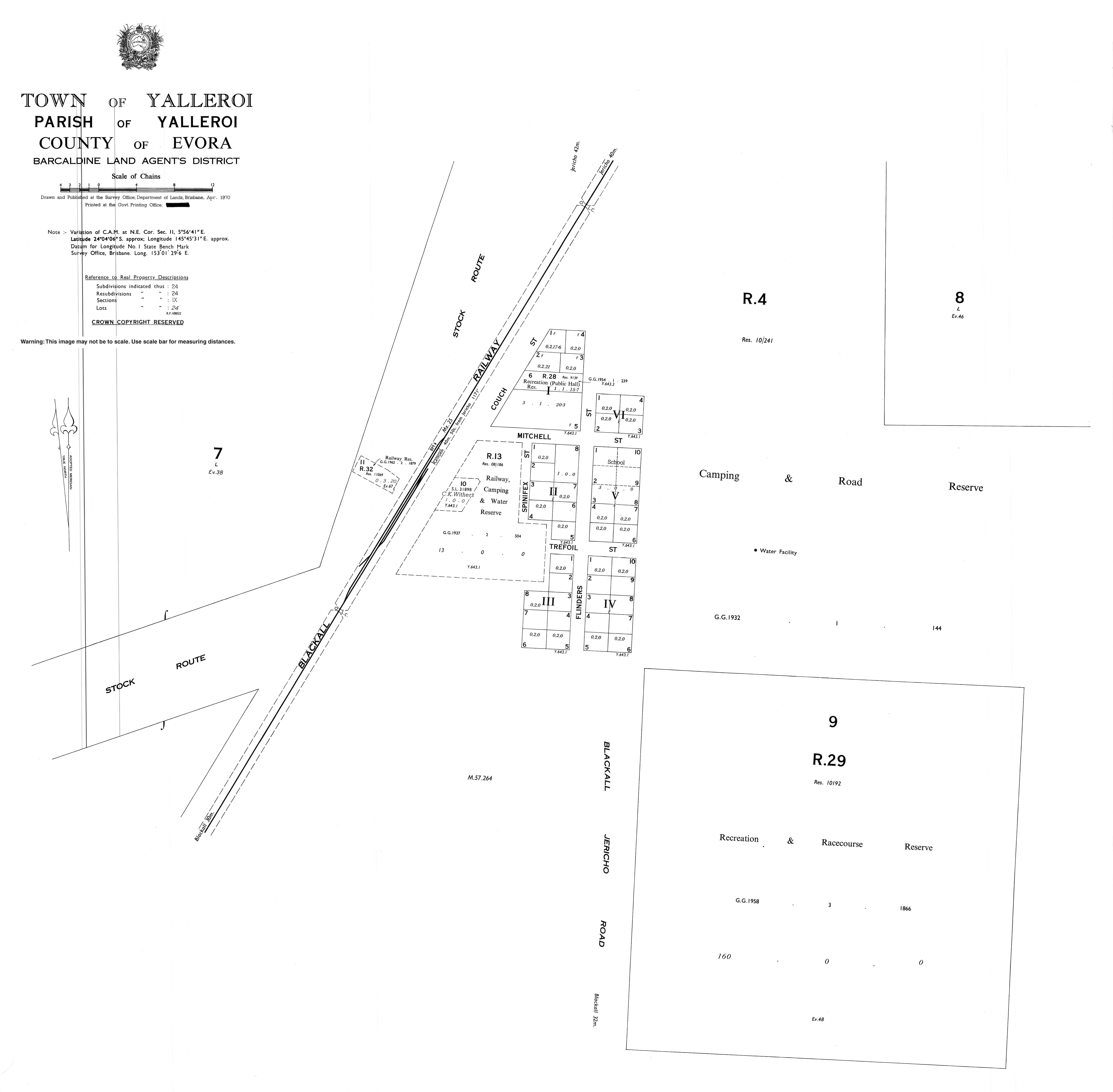
| Yalleroi State School | Yalleroi | Blackall-Tambo | 1933 | 1983 | 24°04′03″S145°45′37″E / 24.0674°S 145.7603°E | Located on the south-east corner of Mitchell Street and Flinders Street. [300] |
| Yaparaba State School | Lawgi Dawes | Banana | 1934 | 1970 | approx 24°38′07″S150°42′28″E / 24.63521°S 150.70782°E | Located on a bend in Yaparaba School Road to the immediate south of the never-constructed Yaparaba railway station on the never-constructed section of the Callide Valley railway line. [156] |
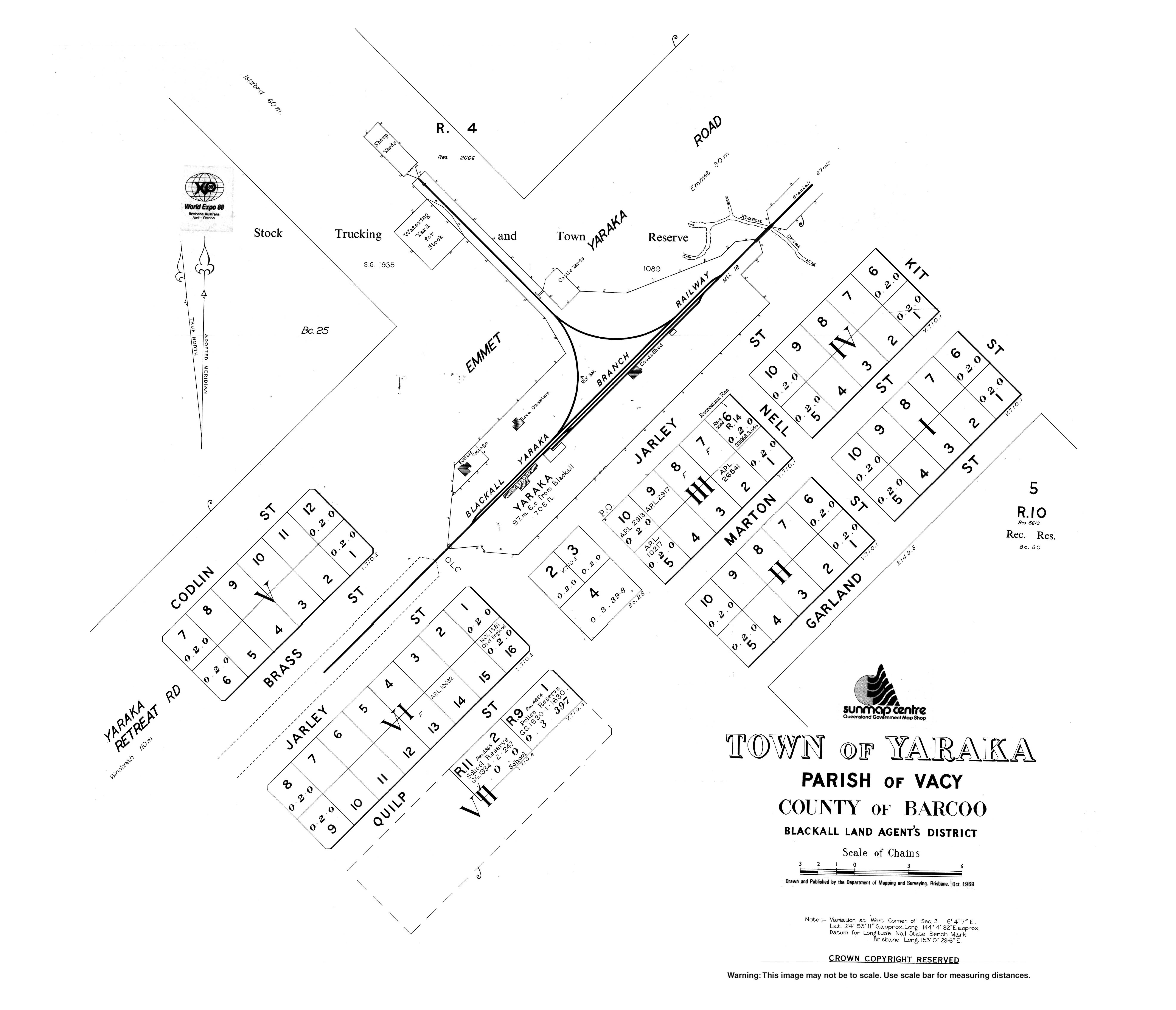
| Yaraka State School | Yaraka | Longreach | 1920 | 2009 | 24°53′10″S144°04′31″E / 24.8861°S 144.0754°E | Located at 11 Quilp Street. [301] The school's website was archived. [302] |
| Yeppoon State Infants School | Yeppoon | Livingstone | 1957 | 1968 | Merged into SS |
In Queensland, Catholic primary schools are usually (but not always) linked to a parish. Prior to the 1970s, most schools were founded by religious institutes, but with the decrease in membership of these institutes, together with major reforms inside the church, lay teachers and administrators began to take over the schools, a process which completed by approximately 1990.
Within the region, schools are administered by Catholic Education Office, Diocese of Rockhampton, which was established in 1966 and was the first Catholic Education Office (CEO) in Queensland. They are supported by the Queensland Catholic Education Commission, which is responsible for coordinating administration, curriculum and policy across the Catholic school system. Preference for enrolment is given to Catholic students from the parish or local area, although non-Catholic students are admitted if room is available.
| Name | Suburb | LGA | M/F/Co-ed | Years | Opened | Coordinates | Notes |
|---|---|---|---|---|---|---|---|
| Chanel College | West Gladstone | Gladstone | Co-ed | 7–12 | 1966 | ||
| Emmaus College | Park Avenue | Rockhampton | Co-ed | 7–12 | 1983 | ||
| Marist College Emerald | Emerald | Central Highlands | Co-ed | 7–12 | 1996 | 23°32′37″S148°09′33″E / 23.5435°S 148.1592°E | At 30 Jeppesen Drive. [303] |
| Our Lady's Primary School | Longreach | Longreach | Co-ed | P–6 | 1902 | ||
| Our Lady of the Sacred Heart Primary School | Springsure | Central Highlands | Co-ed | P–6 | 1926 | ||
| Rockhampton Flexible Learning Centre | Rockhampton | Rockhampton | Co-ed | 7–12 | Operated by Edmund Rice Foundation. | ||
| Sacred Heart Primary School (Yeppoon) | Lammermoor | Livingstone | Co-ed | P–6 | 1958 | ||
| St Anthony's Catholic Primary School | Norman Gardens | Rockhampton | Co-ed | P–6 | 1900 | ||
| St Benedict's Catholic Primary School | Pacific Heights | Livingstone | Co-ed | P–6 | 2009 | ||
| St. Brendan's College | Adelaide Park | Livingstone | M | 7–12 | 1939 | 23°06′58″S150°43′48″E / 23.1162°S 150.7300°E | 139 Adelaide Park Road. [304] |
| St Brigid's Catholic Primary School | Emerald | Central Highlands | Co-ed | P–6 | 2014 | 23°33′35″S148°10′11″E / 23.5597°S 148.1696°E | At 6311 Gregory Highway. [305] [306] |
| St Francis' Catholic Primary School | Tannum Sands | Gladstone | Co-ed | P–6 | 2005 | 23°56′35″S151°21′39″E / 23.9431°S 151.3609°E | At 1 Francis Way. [307] |
| St John the Baptist Catholic Primary School | Clinton | Gladstone | Co-ed | P–6 | 1977 | ||
| St Joseph's Catholic Primary School | Barcaldine | Barcaldine | Co-ed | P–6 | 1896 | ||
| St Joseph's Catholic School | Biloela | Banana | Co-ed | P–6 | 1939 | ||
| St Joseph's Catholic Primary School | Blackall | Blackall-Tambo | Co-ed | P–6 | 1917 | ||
| St Joseph's School | Clermont | Central Highlands | Co-ed | P–6 | 1900 | 22°49′19″S147°38′21″E / 22.8220°S 147.6391°E | At 50 Box Street. [308] |
| St Joseph's Primary School | Park Avenue | Rockhampton | Co-ed | P–6 | 1929 | ||
| St Joseph's Primary School | Wandal | Rockhampton | Co-ed | P–6 | 1916 | ||
| St Mary's Catholic Primary School | Berserker | Rockhampton | Co-ed | P–6 | 1900 | ||
| St Patrick's School | Emerald | Central Highlands | Co-ed | P–6 | 1902 | 23°31′24″S148°09′44″E / 23.5233°S 148.1621°E | At 41 Yamala Street. [309] |
| St Patrick's School | Winton | Winton | Co-ed | P–6 | 1906 | 22°23′06″S143°02′24″E / 22.3851°S 143.0399°E | At Oondooroo Street. [310] |
| St Paul's Primary School | Gracemere | Rockhampton | Co-ed | P–6 | 1988 | ||
| St Peter's School | Allenstown | Rockhampton | Co-ed | P–6 | 1934 | ||
| St Ursula's College | Yeppoon | Livingstone | F | 7–12 | 1918 | 23°07′48″S150°44′36″E / 23.1300°S 150.7434°E | 42–62 Queen Street. [311] |
| Star of the Sea School | Gladstone Central | Gladstone | Co-ed | P–6 | 1902 | ||
| The Cathedral College | Allenstown | Rockhampton | Co-ed | 7–12 | 1991 | 23°23′10″S150°30′18″E / 23.3861°S 150.5051°E | At 189 William Street. [312] |
| Name | Suburb | LGA | M/F/Co-ed | Years | Category | Opened | Coords | Notes |
|---|---|---|---|---|---|---|---|---|
| Carinity Education | Glenlee | Livingstone | Co-ed | ? | Baptist | 1996 | Alternative [313] | |
| Clearview Christian College | Tannum Sands | Gladstone | Co-ed | 7–12 | Christian | 2023 | 23°56′24″S151°21′58″E / 23.9401°S 151.3662°E | At 1 Canoe Point Road (). [314] As at 2025, it offers Years 7 to 10, but, by 2027, will offer Years 7 to 12. [315] |
| Discovery Christian College | Agnes Water | Gladstone | Co-ed | P–12 | Christian | 2015 | ||
| Emerald Christian College | Emerald | Central Highlands | Co-ed | P–12 | Christian | 2001 | 23°33′10″S148°10′15″E / 23.5528°S 148.1708°E | At 6373 Gregory Highway. [316] |
| Faith Baptist Christian School | Burua | Gladstone | Co-ed | P–12 | Baptist | 1998 | ||
| Goora Gan Steiner School | Agnes Water | Gladstone | Co-ed | P–6 | Steiner | |||
| Heights College | Kawana | Rockhampton | Co-ed | P–12 | Assemblies of God | 1989 | Cathedral of Praise Christian College until 2003 | |
| Kingsley College | The Common | Rockhampton | Co-ed | P–12 | Christian | 1993 | Formerly Central Queensland Christian College | |
| Lighthouse Christian School | Norman Gardens | Rockhampton | Co-ed | P–12 | Baptist | 1994 | Formerly Norman Park Christian School | |
| Ontrack College Emerald | Emerald | Central Highlands | Co-ed | 7–10 | Christian | 2018 | 23°31′36″S148°09′41″E / 23.5266°S 148.1614°E | For students who have disengaged from mainstream schools. At 114 Borilla Street. [317] [318] |
| Redeemer Lutheran College | Biloela | Banana | Co-ed | P–12 | Lutheran | 1978 | ||
| Rockhampton Girls Grammar School | The Range | Rockhampton | F | P–12 | Non-denominational | 1892 | ||
| Rockhampton Grammar School | The Range | Rockhampton | Co-ed | P–12 | Non-denominational | 1881 | ||
| Trinity College | Sun Valley | Gladstone | Co-ed | P–12 | Baptist | 1985 | ||
| Wadja Wadja High School | Woorabinda | Woorabinda | Co-ed | 7–12 | Aboriginal | 1991 | 24°08′00″S149°27′22″E / 24.1332°S 149.4560°E | At 116 Munns Drive. [319] |
| Name | Suburb | LGA | Category | Years | Opened | Closed | Notes |
|---|---|---|---|---|---|---|---|
| Capricorn Christian Primary School | Kawana | Rockhampton | 7DA | Primary | 1972 | 2001 | |
| Glenden Christian School | Glenden | Isaac | Christian | Primary | 1995 | 1997 | |
| Marian College | Park Avenue | Rockhampton | Catholic girls | High | 1964 | 1983 | Merged into Emmaus College |
| Range Convent High School | Rockhampton City | Rockhampton | Catholic girls | High | 1896 | 1990 | Merged into The Cathedral College |
| Range Convent High School | Woorabinda | Woorabinda | Catholic | High | 1987 | 1990 | |
| Sacred Heart Primary School | Mount Morgan | Rockhampton | Catholic | Primary | 1891 | 1997 | |
| St Faith's School | Yeppoon | Livingstone | Anglican Girls | P–12 | 1923 | 1968 | |
| St Joseph's Christian Brothers College | Rockhampton City | Rockhampton | Catholic boys | High | 1894 | 1990 | Merged into The Cathedral College |
| St Mary's School | Taroom | Banana | Catholic | Primary | 1920 | 2015 | |
| St Stanislaus College | Park Avenue | Rockhampton | Catholic boys | High | 1958 | 1983 | Merged into Emmaus College |
| St Stephen's Lutheran College | Glen Eden | Gladstone | Lutheran | P–12 | 2002 | 2016 | |
| Stella Maris College | Gladstone | Gladstone | Catholic | High | 1966 | 1976 | Became Part of Chanel College |
Land parcel 51N25413 has name attribute Old Cairdbeign School