Dalma, Queensland

Last updated

Dalma
Queensland
Australia Queensland location map.svg
Red pog.svg
Dalma
Coordinates 23°21′29″S150°13′36″E / 23.3580°S 150.2266°E / -23.3580; 150.2266 (Dalma (centre of locality))
Population78 (2016 census) [1]
 • Density0.841/km2 (2.177/sq mi)
Postcode(s) 4702
Area92.8 km2 (35.8 sq mi)
Time zone AEST (UTC+10:00)
Location
LGA(s) Rockhampton Region
State electorate(s) Mirani
Federal division(s) Flynn
Suburbs around Dalma:
Morinish Ridgelands Ridgelands
Morinish Dalma Alton Downs
Kalapa Stanwell Nine Mile

Dalma is a rural locality in the Rockhampton Region, Queensland, Australia. [2] In the 2016 census, Dalma had a population of 78 people. [1]

Contents

History

Dalma Provisional School opened on 5 March 1889 and closed on 1893. [3]

Dalma Road Provisional School opened on 25 February 1901. On 1 January 1909, it became Dalma Road State School. It closed in 1934. [3] It was at 32 Harding Road in the present-day locality of Alton Downs (north-west corner of Nicholson Road, 23°20′43″S150°20′52″E / 23.3454°S 150.3478°E / -23.3454; 150.3478 (Dalma Road State School (former)) ). [4] [5]

Dalma Scrub Provisional School opened in May 1920. In 1926 it became Dalma Scrub State School. In 1947, it was renamed Dalma State School. It was "mothballed" on 30 January 2006 and closed on 31 December 2006. [3] [6] It was at 5 Shannen Road ( 23°21′13″S150°14′36″E / 23.3537°S 150.2432°E / -23.3537; 150.2432 (Dalma State School (former)) ). [7] [8]

In the 2016 census, Dalma had a population of 78 people. [1]

Education

There are no schools in Dalma. The nearest government primary schools are Ridgelands State School in neighbouring Ridgelands to the north and Stanwell State School in neighbouring Stanwell to the south. The nearest government secondary school is Rockhampton State High School in Wandal, Rockhampton. [5]

Related Research Articles

<span class="mw-page-title-main">Dululu</span> Town in Queensland, Australia

Dululu is a rural town and locality in the Shire of Banana, Queensland, Australia. In the 2016 census, the locality of Dululu had a population of 126 people.

<span class="mw-page-title-main">Raglan, Queensland</span> Town in Queensland, Australia

Raglan is a rural town and locality in the Gladstone Region, Queensland, Australia. In the 2016 census, the locality of Raglan had a population of 146 people.

<span class="mw-page-title-main">Bouldercombe</span> Town in Queensland, Australia

Bouldercombe is a rural town and locality in the Rockhampton Region, Queensland, Australia. In the 2016 census, the locality of Bouldercombe had a population of 1,085 people.

<span class="mw-page-title-main">Ambrose, Queensland</span> Town in Queensland, Australia

Ambrose is a rural town and locality in the Gladstone Region, Queensland, Australia. In the 2016 census, the locality of Ambrose had a population of 218 people.

Bracewell is a rural locality in the Gladstone Region, Queensland, Australia. In the 2016 census, Bracewell had a population of 196 people.

Kabra is a rural town and locality in the Rockhampton Region, Queensland, Australia. In the 2016 census the locality of Kabra had a population of 421 people.

<span class="mw-page-title-main">Stanwell, Queensland</span> Suburb of Rockhampton Region, Queensland, Australia

Stanwell is a rural town and locality in the Rockhampton Region, Queensland, Australia. In the 2016 census the locality of Stanwell had a population of 337 people.

<span class="mw-page-title-main">Morinish, Queensland</span> Suburb of Rockhampton Region, Queensland, Australia

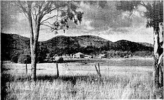
Morinish is a rural locality in the Rockhampton Region, Queensland, Australia. In the 2021 census, Morinish had a population of 62 people.

<span class="mw-page-title-main">Bajool, Queensland</span> Suburb of Rockhampton Region, Queensland, Australia

Bajool is a rural town and locality in the Rockhampton Region, Queensland, Australia. In the 2016 census, the locality of Bajool had a population of 455 people.

<span class="mw-page-title-main">Ridgelands, Queensland</span> Suburb of Rockhampton Region, Queensland, Australia

Ridgelands is a rural locality in the Rockhampton Region, Queensland, Australia. In the 2016 census Ridgelands had a population of 166 people.

Alsace is a rural locality in the Central Highlands Region, Queensland, Australia. In the 2016 census, Alsace had a population of 3 people.

<span class="mw-page-title-main">Alton Downs, Queensland</span> Suburb of Rockhampton Region, Queensland, Australia

Alton Downs is a rural locality in the Rockhampton Region, Queensland, Australia. In the 2016 census, Alton Downs had a population of 1,278 people.

Garnant is a rural locality in the Rockhampton Region, Queensland, Australia. In the 2016 census Garnant had a population of 99 people.

Hamilton Creek is a rural locality in the Rockhampton Region, Queensland, Australia. In the 2016 census, Hamilton Creek had a population of 104 people.

Glenlee is a rural locality in the Livingstone Shire, Queensland, Australia. In the 2016 census, Glenlee had a population of 1,236 people.

Mount Marlow is a rural locality in the Whitsunday Region, Queensland, Australia. In the 2016 census Mount Marlow had a population of 132 people.

<span class="mw-page-title-main">Lawgi Dawes</span> Suburb of Shire of Banana, Queensland, Australia

Lawgi Dawes is a rural locality in the Shire of Banana, Queensland, Australia. In the 2016 census, Lawgi Dawes had a population of 144 people. It contains the neighbourhood of Lawgi, a former town.

<span class="mw-page-title-main">Bushley, Queensland</span> Suburb of Rockhampton Region, Queensland, Australia

Bushley is a rural locality in the Rockhampton Region, Queensland, Australia. In the 2016 census, Bushley had a population of 30 people.

<span class="mw-page-title-main">Boulder Creek, Queensland</span> Suburb of Rockhampton Region, Queensland, Australia

Boulder Creek is a rural locality in the Rockhampton Region, Queensland, Australia. In the 2021 census, Boulder Creek had a population of 13 people.

Limestone is a rural locality in the Rockhampton Region, Queensland, Australia. In the 2021 census, Limestone had a population of 16 people.

References

  1. 1 2 3 Australian Bureau of Statistics (27 June 2017). "Dalma (SSC)". 2016 Census QuickStats. Retrieved 20 October 2018. OOjs UI icon edit-ltr-progressive.svg
  2. "Dalma – locality in Rockhampton Region (entry 48598)". Queensland Place Names. Queensland Government . Retrieved 28 December 2020.
  3. 1 2 3 Queensland Family History Society (2010), Queensland schools past and present (Version 1.01 ed.), Queensland Family History Society, ISBN   978-1-921171-26-0
  4. "County of Livingstone sheet 1" (Map). Queensland Government. 1923. Retrieved 14 August 2023.
  5. 1 2 "Queensland Globe". State of Queensland . Retrieved 14 August 2023.
  6. "Queensland state school - centre closures" (PDF). Queensland Government . 20 August 2013. Archived (PDF) from the original on 20 March 2022. Retrieved 6 April 2022.
  7. "Parish of Limestone" (Map). Queensland Government. 1972. Archived from the original on 29 December 2020. Retrieved 30 December 2020.
  8. "5 Shannen Road, Dalma, Qld 4702". Realestate.com.au . Retrieved 22 April 2022.[ permanent dead link ]