Wura, Queensland

Last updated

Map all coordinates using: OpenStreetMap
Wura
Queensland
Australia Queensland location map.svg
Red pog.svg
Wura
Coordinates 23°47′27″S150°19′50″E / 23.7908°S 150.3305°E / -23.7908; 150.3305 (Wura (centre of locality))
Population17 (SAL 2021) [1]
Postcode(s) 4714
Area25.2 km2 (9.7 sq mi)
Time zone AEST (UTC+10:00)
Location
LGA(s) Rockhampton Region
State electorate(s) Mirani
Federal division(s) Flynn
Suburbs around Wura:
Westwood Oakey Creek Fletcher Creek
Westwood Wura Fletcher Creek
Dululu Dululu Ulogie

Wura is a rural locality in the Rockhampton Region, Queensland, Australia. [2] In the 2021 census, Wura had a population of 17 people. [3]

Contents

Geography

The locality is bounded to the east, south-east, and south by the Dee River. [4]

The Burnett Highway enters the locality from the north (Oakey Creek) and exits to the south-west (Dululu). [4]

History

The locality takes its name from its former railway station, which is believed to be an Aboriginal word meaning kangaroo . [2] [5]

The Dawson Valley railway line from Mount Morgan to Wowan opened on 16 October 1912 with Wura being served by:

This section of the line closed on 1 August 1987 and the station is now abandoned. [9] [10]

Konara State School opened in 1919. It closed in 1927. [11] It was north of the Konara railway station, between the railway line and the Dee River, just south of the confluence with Fletcher Creek (approx 23°45′48″S150°21′36″E / 23.7633°S 150.36009°E / -23.7633; 150.36009 (Konara State School (former)) ), now in Oakey Creek. [7] [4]

Wura State School opened on 10 March 1924 and closed circa 1944. [11] It was between the Wura railway station and the Dee River (approx 23°48′58″S150°19′38″E / 23.8160°S 150.3273°E / -23.8160; 150.3273 (Wura State School (former)) ). [7] [4]

Demographics

In the 2016 census, Wura had a population of 15 people. [12]

In the 2021 census, Wura had a population of 17 people. [3]

Education

There are no school in Wura. The nearest government primary schools are Mount Morgan Central State School in Mount Morgan to the north-east and Wowan State School in Wowan to the south-east. The nearest government secondary school is Mount Morgan State High School, also in Mount Morgan. [4]

Related Research Articles

<span class="mw-page-title-main">Mount Morgan, Queensland</span> City in Queensland, Australia

Mount Morgan is a rural town and locality in the Rockhampton Region, Queensland, Australia. In the 2021 census the town of Mount Morgan had a population of 2,487 people.

<span class="mw-page-title-main">Westwood, Queensland</span> Town in Queensland, Australia

Westwood is a town in the Rockhampton Region and a locality split between the Rockhampton Region and the Shire of Banana in Queensland, Australia. It was the first town that was gazetted by the Queensland Government. In the 2021 census, the locality of Westwood had a population of 199 people.

<span class="mw-page-title-main">Dululu</span> Town in Queensland, Australia

Dululu is a rural town and locality in the Shire of Banana, Queensland, Australia. In the 2016 census, the locality of Dululu had a population of 126 people.

<span class="mw-page-title-main">Wowan, Queensland</span> Town in Queensland, Australia

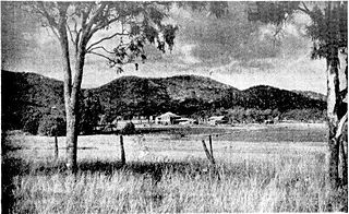
Wowan is a rural town and locality in the Shire of Banana, Queensland, Australia. In the 2016 census, the locality of Wowan had a population of 216 people.

<span class="mw-page-title-main">Jambin, Queensland</span> Town in Queensland, Australia

Jambin is a rural town and locality in the Shire of Banana, Queensland, Australia.

<span class="mw-page-title-main">Marmor, Queensland</span> Town in Queensland, Australia

Marmor is a rural town and locality in the Rockhampton Region, Queensland, Australia. In the 2016 census, the locality of Marmor had a population of 212 people.

<span class="mw-page-title-main">Dawson Valley (Theodore) railway line</span>

The Dawson Valley Branch Railway was a railway line in Central Queensland, Australia. It branched from the Central Western railway line at Kabra in the Rockhampton Region and went via Mount Morgan to Theodore in the Shire of Banana. It opened in a series of sections between 1898 and 1927, and featured a rack railway section, one of only 3 such systems in Australia.

<span class="mw-page-title-main">Raglan, Queensland</span> Town in Queensland, Australia

Raglan is a rural town and locality in the Gladstone Region, Queensland, Australia. In the 2016 census, the locality of Raglan had a population of 146 people.

<span class="mw-page-title-main">Baree, Queensland</span> Suburb of Rockhampton Region, Queensland, Australia

Baree is a rural locality in the Rockhampton Region, Queensland, Australia. In the 2021 census, Baree had a population of 201 people.

<span class="mw-page-title-main">Bouldercombe</span> Town in Queensland, Australia

Bouldercombe is a rural town and locality in the Rockhampton Region, Queensland, Australia. In the 2016 census, the locality of Bouldercombe had a population of 1,085 people.

Kabra is a rural town and locality in the Rockhampton Region, Queensland, Australia. In the 2016 census the locality of Kabra had a population of 421 people.

<span class="mw-page-title-main">Stanwell, Queensland</span> Suburb of Rockhampton Region, Queensland, Australia

Stanwell is a rural town and locality in the Rockhampton Region, Queensland, Australia. In the 2016 census the locality of Stanwell had a population of 337 people.

<span class="mw-page-title-main">Bajool, Queensland</span> Suburb of Rockhampton Region, Queensland, Australia

Bajool is a rural town and locality in the Rockhampton Region, Queensland, Australia. In the 2016 census, the locality of Bajool had a population of 455 people.

<span class="mw-page-title-main">Gogango</span> Town in Queensland, Australia

Gogango is a rural town and locality in the Rockhampton Region, Queensland, Australia. In the 2016 census the locality of Gogango had a population of 111 people.

<span class="mw-page-title-main">Mount Chalmers, Queensland</span> Town in Queensland, Australia

Mount Chalmers is a rural town and locality in the Livingstone Shire, Queensland, Australia. In the 2016 census, the locality of Mount Chalmers had a population of 235 people.

Oakey Creek is a rural locality in the Rockhampton Region, Queensland, Australia. In the 2016 census Oakey Creek had a population of 3 people.

Pink Lily is a rural locality in the Rockhampton Region, Queensland, Australia. In the 2016 census Pink Lily had a population of 231 people. The proposed Rockhampton Ring Road will pass through Pink Lily.

<span class="mw-page-title-main">Boulder Creek, Queensland</span> Suburb of Rockhampton Region, Queensland, Australia

Boulder Creek is a rural locality in the Rockhampton Region, Queensland, Australia. In the 2021 census, Boulder Creek had a population of 13 people.

Walmul is a rural locality in the Rockhampton Region, Queensland, Australia. In the 2021 census, Walmul had a population of 21 people.

<span class="mw-page-title-main">Moongan, Queensland</span> Suburb of Rockhampton Region, Queensland, Australia

Moongan is a rural locality in the Rockhampton Region, Queensland, Australia. In the 2021 census, Moongan had a population of 120 people.

References

  1. Australian Bureau of Statistics (28 June 2022). "Wura (Suburb and Locality)". Australian Census 2021 QuickStats. Retrieved 28 June 2022.  OOjs UI icon edit-ltr-progressive.svg
  2. 1 2 "Wura – locality in Rockhampton Region (entry 48948)". Queensland Place Names. Queensland Government . Retrieved 26 October 2019.
  3. 1 2 Australian Bureau of Statistics (28 June 2022). "Wura (SAL)". 2021 Census QuickStats. Retrieved 28 February 2023. OOjs UI icon edit-ltr-progressive.svg
  4. 1 2 3 4 5 "Queensland Globe". State of Queensland . Retrieved 25 August 2023.
  5. "QUEENSLAND RAILWAY NOMENCLATURE". The Queenslander . No. 2458. Queensland, Australia. 25 April 1914. p. 8. Retrieved 27 October 2019 via National Library of Australia.
  6. "Konara – railway station in Rockhampton Region (feature is absent) (entry 39276)". Queensland Place Names. Queensland Government . Retrieved 25 August 2023.
  7. 1 2 3 4 5 "Queensland Two Mile series sheet 2m201" (Map). Queensland Government. 1937. Archived from the original on 25 August 2023. Retrieved 25 August 2023.
  8. "Geobera – railway station in the Rockhampton Region (feature no longer exists) (entry 39259)". Queensland Place Names. Queensland Government . Retrieved 25 August 2023.
  9. 1 2 "Railway stations and sidings - Queensland". Queensland Open Data. Queensland Government. 2 October 2020. Archived from the original on 5 October 2020. Retrieved 5 October 2020.
  10. "The Mount Morgan Railway". www.mountmorgan.org.au. Archived from the original on 28 May 2023. Retrieved 28 July 2023.
  11. 1 2 Queensland Family History Society (2010), Queensland schools past and present (Version 1.01 ed.), Queensland Family History Society, ISBN   978-1-921171-26-0
  12. Australian Bureau of Statistics (27 June 2017). "Wura (SSC)". 2016 Census QuickStats. Retrieved 20 October 2018. OOjs UI icon edit-ltr-progressive.svg