Morinish, Queensland

Last updated

Map all coordinates using: OpenStreetMap
Morinish
Queensland
Alliance Mine in operation at Morinish, Queensland, circa 1890.JPG
Alliance Mine in operation at Morinish, circa 1890
Australia Queensland location map.svg
Red pog.svg
Morinish
Coordinates 23°12′18″S150°03′09″E / 23.205°S 150.0525°E / -23.205; 150.0525 (Morinish (centre of locality))
Population62 (SAL 2021) [1]
Postcode(s) 4702
Area756.3 km2 (292.0 sq mi)
Time zone AEST (UTC+10:00)
Location
LGA(s) Rockhampton Region
State electorate(s) Mirani
Federal division(s) Flynn
Suburbs around Morinish:
Glenroy Canoona Garnant
Glenroy Morinish Ridgelands
Glenroy Morinish South Dalma
Kalapa

Morinish is a rural locality in the Rockhampton Region, Queensland, Australia. [2] In the 2021 census, Morinish had a population of 62 people. [3]

Contents

Geography

The locality is bounded by the Fitzroy River to the north and west. [4]

Ten Mile Creek rises in the south-west of the locality ( 23°17′11″S150°02′16″E / 23.2864°S 150.0377°E / -23.2864; 150.0377 (Ten Mile Creek (source)) ) and flows northward through the locality where it becomes a tributary of the Fitzroy River ( 23°05′10″S150°00′04″E / 23.0861°S 150.0010°E / -23.0861; 150.0010 (Ten Mile Creek (mouth)) ). [4] [5]

The former town of Morinish is south of centre of the locality (approx 23°15′09″S150°08′18″E / 23.2524°S 150.1382°E / -23.2524; 150.1382 (Morinish (former town)) ). [6] [7] [8]

History

Gold was found at Morinish in 1866 with miners working in the area by December 1866, [9] and a "new rush" being described in the newspapers in February 1867 with the population being estimated on the field as 600. [10] [11]

The Morinish Post Office opened on 1 July 1867 and closed on 4 November 1872. [12]

There were at least three major mines in the period of 1880s to 1900s: Welcome Reef, Alliance Mine and Mount Morinish Mine. [13]

Perhaps reflecting the changing fortunes on the goldfields, schooling in Morinish was available intermittently.

Morinish Provisional School opened circa 1882 and closed circa 1890. [14] A second Morinish Provisional School opened circa 1894 and closed circa 1897, but it is not known if this was first school re-opening or a different school. [14]

In 1902, two new provisional schools opened called Morinish No 1 Provisional School and Morinish No 2 Provisional School. They were half-time schools (meaning they shared a single teacher between them). In 1915, the No 2 school was closed and the No 1 school became the full-time Morinish State School. It closed in 1928 due to "insufficient pupils". [14] [15] In 1930, the school building was relocated to establish the State School at Garnant. [16] [17] [18] Morinish State School was on Morinish Road (approx 23°15′04″S150°09′24″E / 23.2512°S 150.1566°E / -23.2512; 150.1566 (Morinish State School (former)) ). [19] [4]

Ten Mile Creek Provisional School opened in 1916 but closed circa 1917. [14]

Morinish was within the Shire of Fitzroy until 2008 when amalgamation of local government areas resulted in it becoming part of the newly created Rockhampton Region.

Demographics

In the 2016 census, Morinish had a population of 89 people. [20]

In the 2021 census, Morinish had a population of 62 people. [3]

Education

There are no school in Morinish. The nearest government primary school is Ridgelands State School in neighbouring Ridgelands to the west. The nearest government secondary school is Rockhampton State High School in Wandal, a suburb of Rockhampton; however, it is sufficiently distant that other options would be distance education and boarding school. [4]

Notable residents

Related Research Articles

<span class="mw-page-title-main">Westwood, Queensland</span> Town in Queensland, Australia

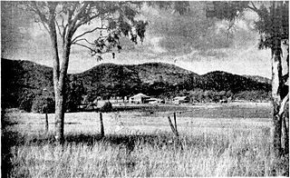
Westwood is a town in the Rockhampton Region and a locality split between the Rockhampton Region and the Shire of Banana in Queensland, Australia. It was the first town that was gazetted by the Queensland Government. In the 2021 census, the locality of Westwood had a population of 199 people.

<span class="mw-page-title-main">Chinchilla, Queensland</span> Town in Queensland, Australia

Chinchilla is a rural town and locality in the Western Downs Region, Queensland, Australia. In the 2021 census, the locality of Chinchilla had a population of 7,068 people.

The Common is a parkland suburb of Rockhampton in the Rockhampton Region, Queensland, Australia. In the 2016 census The Common had a population of 0 people.

<span class="mw-page-title-main">Marmor, Queensland</span> Town in Queensland, Australia

Marmor is a rural town and locality in the Rockhampton Region, Queensland, Australia. In the 2016 census, the locality of Marmor had a population of 212 people.

<span class="mw-page-title-main">Raglan, Queensland</span> Town in Queensland, Australia

Raglan is a rural town and locality in the Gladstone Region, Queensland, Australia. In the 2016 census, the locality of Raglan had a population of 146 people.

<span class="mw-page-title-main">Bouldercombe</span> Town in Queensland, Australia

Bouldercombe is a rural town and locality in the Rockhampton Region, Queensland, Australia. In the 2016 census, the locality of Bouldercombe had a population of 1,085 people.

<span class="mw-page-title-main">Ambrose, Queensland</span> Town in Queensland, Australia

Ambrose is a rural town and locality in the Gladstone Region, Queensland, Australia. In the 2016 census, the locality of Ambrose had a population of 218 people.

Kabra is a rural town and locality in the Rockhampton Region, Queensland, Australia. In the 2016 census the locality of Kabra had a population of 421 people.

<span class="mw-page-title-main">Bajool, Queensland</span> Suburb of Rockhampton Region, Queensland, Australia

Bajool is a rural town and locality in the Rockhampton Region, Queensland, Australia. In the 2016 census, the locality of Bajool had a population of 455 people.

<span class="mw-page-title-main">Gogango</span> Town in Queensland, Australia

Gogango is a rural town and locality in the Rockhampton Region, Queensland, Australia. In the 2016 census the locality of Gogango had a population of 111 people.

<span class="mw-page-title-main">Yaamba</span> Suburb of Shire of Livingstone, Queensland, Australia

Yaamba is a rural town and locality in the Livingstone Shire, Queensland, Australia. In the 2016 census, the locality of Yaamba had a population of 62 people.

<span class="mw-page-title-main">Nerimbera, Queensland</span> Suburb of Shire of Livingstone, Queensland, Australia

Nerimbera is a rural locality in the Livingstone Shire, Queensland, Australia. In the 2016 census, Nerimbera had a population of 293 people.

Lakes Creek is a suburb split between Rockhampton Region and Shire of Livingstone, Queensland, Australia. In the 2016 census Lakes Creek had a population of 552 people.

<span class="mw-page-title-main">Ridgelands, Queensland</span> Suburb of Rockhampton Region, Queensland, Australia

Ridgelands is a rural locality in the Rockhampton Region, Queensland, Australia. In the 2016 census Ridgelands had a population of 166 people.

<span class="mw-page-title-main">Alton Downs, Queensland</span> Suburb of Rockhampton Region, Queensland, Australia

Alton Downs is a rural locality in the Rockhampton Region, Queensland, Australia. In the 2016 census, Alton Downs had a population of 1,278 people.

Dalma is a rural locality in the Rockhampton Region, Queensland, Australia. In the 2016 census, Dalma had a population of 78 people.

Garnant is a rural locality in the Rockhampton Region, Queensland, Australia. In the 2016 census Garnant had a population of 99 people.

<span class="mw-page-title-main">Lawgi Dawes</span> Suburb of Shire of Banana, Queensland, Australia

Lawgi Dawes is a rural locality in the Shire of Banana, Queensland, Australia. In the 2016 census, Lawgi Dawes had a population of 144 people. It contains the neighbourhood of Lawgi, a former town.

<span class="mw-page-title-main">Thompson Point, Queensland</span> Suburb of Livingstone Shire, Queensland, Australia

Thompson Point is a coastal locality in the Livingstone Shire, Queensland, Australia. It was the site of a short-lived town and port called Broadmount. In the 2021 census, Thompson Point had a population of 4 people.

<span class="mw-page-title-main">Boulder Creek, Queensland</span> Suburb of Rockhampton Region, Queensland, Australia

Boulder Creek is a rural locality in the Rockhampton Region, Queensland, Australia. In the 2021 census, Boulder Creek had a population of 13 people.

References

  1. Australian Bureau of Statistics (28 June 2022). "Morinish (Suburb and Locality)". Australian Census 2021 QuickStats. Retrieved 28 June 2022.  OOjs UI icon edit-ltr-progressive.svg
  2. "Morinish – locality in Rockhampton Region (entry 48774)". Queensland Place Names. Queensland Government . Retrieved 29 December 2020.
  3. 1 2 Australian Bureau of Statistics (28 June 2022). "Morinish (SAL)". 2021 Census QuickStats. Retrieved 28 February 2023. OOjs UI icon edit-ltr-progressive.svg
  4. 1 2 3 4 "Queensland Globe". State of Queensland . Retrieved 13 August 2023.
  5. "Ten Mile Creek – watercourse in the Rockhampton Region (entry -23.28640,150.03771)". Queensland Place Names. Queensland Government . Retrieved 16 January 2021.
  6. "County of Livingstone sheet 1" (Map). Queensland Government. 1912. Retrieved 16 January 2021.
  7. "The Gazette". The Brisbane Courier . Vol. XXIII, no. 3, 408. Queensland, Australia. 31 August 1868. p. 3. Retrieved 16 January 2021 via National Library of Australia.
  8. "Proclamation". Queensland Government Gazette . 29 August 1868. p. 9:1005 (PDF) 1007 (page).
  9. "TELEGRAPHIC". The Brisbane Courier . Vol. XXI, no. 2, 781. Queensland, Australia. 25 December 1866. p. 2. Retrieved 13 August 2023 via National Library of Australia.
  10. "QUEENSLAND". South Australian Register . Vol. XXXI, no. 6335. South Australia. 22 February 1867. p. 2. Retrieved 13 August 2023 via National Library of Australia.
  11. "ROCKHAMPTON". Warwick Argus And Tenterfield Chronicle . Vol. III, no. 30. Queensland, Australia. 15 February 1867. p. 2. Retrieved 13 August 2023 via National Library of Australia.
  12. Premier Postal History. "Post Office List". Premier Postal Auctions. Retrieved 4 June 2014.
  13. "Gold occurrences in Central Queensland". Treasure Enterprises of Australia. Retrieved 4 June 2014.
  14. 1 2 3 4 Queensland Family History Society (2010), Queensland schools past and present (Version 1.01 ed.), Queensland Family History Society, ISBN   978-1-921171-26-0
  15. "RIDGELANDS". Morning Bulletin . No. 19, 917. Queensland, Australia. 30 May 1928. p. 10. Retrieved 14 August 2023 via National Library of Australia.
  16. "PUBLIC WORKS". The Brisbane Courier . No. 22, 560. Queensland, Australia. 20 May 1930. p. 10. Retrieved 14 January 2021 via National Library of Australia.
  17. "MORINISH STATE SCHOOL". Morning Bulletin . No. 20, 443. Queensland, Australia. 12 June 1930. p. 8. Retrieved 14 August 2023 via National Library of Australia.
  18. "RIDGELANDS". The Central Queensland Herald . Vol. 1, no. 30. Queensland, Australia. 24 July 1930. p. 44. Retrieved 14 August 2023 via National Library of Australia.
  19. "County of Livingstone sheet 1" (Map). Queensland Government. 1921. Retrieved 14 August 2023.
  20. Australian Bureau of Statistics (27 June 2017). "Morinish (SSC)". 2016 Census QuickStats. Retrieved 20 October 2018. OOjs UI icon edit-ltr-progressive.svg

Further reading