Calliope River Historical Village

Last updated

Village Kiosk (formerly Yarwun Railway Station), 2014 Village Kiosk (formerly Yarwun Railway Station), relocated in 2003 to Calliope River Historical Village, 2014.JPG
Village Kiosk (formerly Yarwun Railway Station), 2014

The Calliope River Historical Village is an open-air museum at 50951 Bruce Highway (on the side road known as Old Bruce Highway) beside the Calliope River in River Ranch in the Gladstone Region, Queensland, Australia. It is operated by the Port Curtis Historical Society. [1]

Contents

History

The centenary celebrations of the Shire of Calliope in 1979 created a collection of historic material, which led to the establishment of the Port Curtis Historical Society. As a new bridge was being constructed for the Bruce Highway to cross the Calliope River, the diversion of the highway to the new bridge created a parcel of land that the shire proposed to use as a historical village. Following site works, the village commenced operation in 1983 with the arrival of the first building, the Ambrose railway station. [2]

Collection

The museum comprises a number of historic buildings from the district which have been relocated to the historical village. Many of the buildings contain exhibits of everyday life and railway history. [3]

The Raglan Memorial Hall was built in about 1932 and was used for dances until 1990, after which it stood idle. It was relocated to the village in March 2002 and officially re-opened by George Creed, the mayor of Calliope Shire. [2] [4]

Village Kiosk (formerly Yarwun Railway Station), 2014 Village Kiosk (formerly Yarwun Railway Station), relocated in 2003 to Calliope River Historical Village (closeup), 2014.JPG
Village Kiosk (formerly Yarwun Railway Station), 2014

Yarwun railway station was relocated to the village and was re-opened in June 2003 as the ticket office and kiosk. [2] [5]

A wooden railway carriage (No. 1353) was built in Ipswich in the early 1940s. It was used on many routes including the Sunshine Mail that ran from Brisbane to Cairns (which was superseded by the Sunlander in the 1960s). Having become surplus to requirements for passenger transport, Queensland Rail had it transported to the village on 1 June 1989 where it serves as a tourist information centre. [2] [6]

Historical survey monument

Although not part of the historical village, immediately outside its entrance is one of the Q150 historical survey makers placed by the Surveying and Spatial Sciences Institute in 2009. This monument commemorates Francis Peter MacCabe, the first surveyor of Gladstone. MacCabe was appointed by the Government of New South Wales to take a surveying party to the Port Curtis area to establish a settlement in 1853. [7]

Related Research Articles

<span class="mw-page-title-main">Calliope, Queensland</span> Town in Queensland, Australia

Calliope is a rural town and locality in the Gladstone Region, Queensland, Australia. In the 2021 census, Calliope had a population of 5,263 people.

<span class="mw-page-title-main">Calliope River</span> River in Queensland, Australia

The Calliope River is a river in Central Queensland, Australia.

<span class="mw-page-title-main">Miriam Vale</span> Town in Queensland, Australia

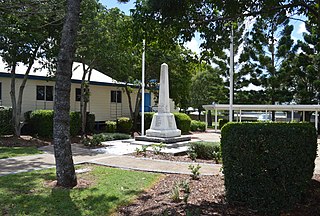
Miriam Vale is a rural town and locality in the Gladstone Region, Queensland, Australia. In the 2016 census, Miriam Vale had a population of 512 people.

<span class="mw-page-title-main">Mount Larcom, Queensland</span> Town in Queensland, Australia

Mount Larcom is the name of a mountain, a rural town and locality in the Gladstone Region, Queensland, Australia. In the 2016 census, the locality of Mount Larcom had a population of 361 people.

<span class="mw-page-title-main">Shire of Calliope</span> Local government area in Queensland, Australia

The Shire of Calliope was a local government area in the Capricornia region of Queensland, Australia. It was centred on the town of Calliope.

<span class="mw-page-title-main">Shire of Miriam Vale</span> Local government area in Queensland, Australia

The Shire of Miriam Vale was a local government area near Gladstone in Queensland, Australia. The administrative centre was the town of Miriam Vale.

<span class="mw-page-title-main">Boyne Valley, Queensland</span> Suburb of Gladstone Region, Queensland, Australia

The Boyne Valley is a rural locality in Gladstone Region, Queensland, Australia. The locality contains four small towns: Nagoorin, Ubobo, Builyan, and Many Peaks. In the 2021 census, Boyne Valley had a population of 301 people.

<span class="mw-page-title-main">Ubobo</span> Town in Queensland, Australia

Ubobo is a rural town in the locality of Boyne Valley in the Gladstone Region, Queensland, Australia.

<span class="mw-page-title-main">Raglan, Queensland</span> Town in Queensland, Australia

Raglan is a rural town and locality in the Gladstone Region, Queensland, Australia. In the 2016 census, the locality of Raglan had a population of 146 people.

<span class="mw-page-title-main">East End, Queensland</span> Suburb of Gladstone Region, Queensland, Australia

East End is a rural locality in the Gladstone Region, Queensland, Australia. In the 2016 census, East End had a population of 59 people.

Machine Creek is a rural locality in the Gladstone Region, Queensland, Australia. In the 2016 census, Machine Creek had a population of 120 people.

<span class="mw-page-title-main">Yarwun, Queensland</span> Suburb of Gladstone Region, Queensland, Australia

Yarwun is a rural coastal town and locality in the Gladstone Region, Queensland, Australia. In the 2016 census the locality of Yarwun had a population of 119 people.

River Ranch is a rural locality in the Gladstone Region, Queensland, Australia. In the 2016 census River Ranch had a population of 357 people.

<span class="mw-page-title-main">Surveying and Spatial Sciences Institute</span>

Important Notice The Surveying and Spatial Sciences Institute merged with the Spatial Industries Business Association in 2022 to form the new peak geospatial body Geospatial Council of Australia (GCA). https://geospatialcouncil.org.au/story/

Francis Peter MacCabe was a surveyor in the colony of New South Wales in the 19th century. He surveyed and mapped the lower reaches of the Murrumbidgee, Darling and Murray Rivers in New South Wales.

<span class="mw-page-title-main">Callemondah</span> Suburb of Gladstone, Queensland, Australia

Callemondah is a coastal suburb of Gladstone in the Gladstone Region, Queensland, Australia. It contains the Port of Gladstone. In the 2016 census Callemondah had a population of 18 people.

Beecher is a rural locality in the Gladstone Region, Queensland, Australia. In the 2016 census, Beecher had a population of 863 people.

Byellee is an industrial suburb of Gladstone in the Gladstone Region, Queensland, Australia. In the 2021 census, Byellee had a population of 0 people.

Gladstone–Monto Road is a 132 kilometres (82 mi) road route in the Gladstone and North Burnett regions of Queensland, Australia. The entire route is signed as State Route 69.

Gladstone–Mount Larcom Road is a continuous 32.1 kilometres (19.9 mi) road route in the Gladstone region of Queensland, Australia. The route is signed as State Route 58. Gladstone–Mount Larcom Road is a state-controlled regional road. As part of State Route 58 it provides an alternate route between Mount Larcom and Benaraby. It is also part of the shortest route from Gladstone to the north of the state.

References

  1. "Calliope River Historical Village". Port Curtis Historical Society. Archived from the original on 20 July 2014. Retrieved 8 July 2014.
  2. 1 2 3 4 Visitor Guide booklet. Port Curtis Historical Society.
  3. "Calliope River Historical Village" (PDF). Museum and Gallery Services Queensland. Archived (PDF) from the original on 4 March 2016. Retrieved 8 July 2014.
  4. "Raglan Memorial Hall". Calliope River Historical Village. Port Curtis Historical Society. Archived from the original on 22 June 2014. Retrieved 10 July 2014.
  5. "The Village Kiosk". Calliope River Historical Village. Port Curtis Historical Society. Archived from the original on 21 June 2014. Retrieved 14 July 2014.
  6. "Tourist Information Centre". Calliope River Historical Village. Port Curtis Historical Society. Archived from the original on 23 July 2014. Retrieved 14 July 2014.
  7. "About the marker locations – Some interesting information". Surveying and Spatial Sciences Institute Q150. Surveying and Spatial Sciences Institute. Archived from the original on 5 June 2014. Retrieved 14 July 2014.

23°57′33″S151°09′21″E / 23.9591°S 151.1557°E / -23.9591; 151.1557