
Carnarvon National Park is located in the Southern Brigalow Belt bioregion in the Maranoa Region in Central Queensland, Australia. The park is 593 km northwest of Brisbane. It began life as a 26,304-hectare (65,000-acre) reserve gazetted in 1932 to protect Carnarvon Gorge for its outstanding scenic values, its Indigenous and non-Indigenous cultural heritage, and its geological significance.

The Brisbane Water National Park is a protected national park that is located in the Central Coast region of New South Wales, in eastern Australia. The 11,506-hectare (28,430-acre) national park is situated 47 kilometres (29 mi) north of Sydney, 10 kilometres (6.2 mi) west of Woy Woy, and 12 kilometres (7.5 mi) southwest of Gosford.

The Nightcap National Park is a national park situated within the Nightcap Range in the Northern Rivers region of New South Wales, Australia. The 8,080-hectare (20,000-acre) park was created in April 1983 and is situated 35 kilometres (22 mi) north of Lismore. The national park is classed by the IUCN World Commission on Protected Areas as Category II and is part of the Shield Volcano Group of the World Heritage Site Gondwana Rainforests of Australia inscribed in 1986 and added to the Australian National Heritage List in 2007. The park was severely burned during the 2019-2020 Australian brushfire season, and its biodiversity has likely been decimated.

Blackdown Tableland is a national park in the Central Highlands Region, Queensland, Australia.
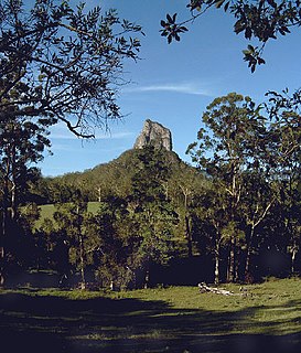
Glass House Mountains National Park is a heritage-listed national park at Glass House Mountains, Sunshine Coast Region, Queensland, Australia. It is also known as Beerburrum Forest Reserve 1. It is 70 km (43 mi) north of Brisbane and consists of a flat plain punctuated by rhyolite and trachyte volcanic plugs, the cores of extinct volcanoes that formed 27 million to 26 million years ago. The mountains would once have had pyroclastic exteriors, but these have eroded away.

Hann Tableland is a national park in Far North Queensland (Australia), 1,436 km northwest of Brisbane. It is located in the northern section of Paddys Green, a locality in the Tablelands Region local government area. It was first set aside as national park in 1989 and nearly doubled in size with an expansion in 2004.

Kondalilla is a national park in the Blackall Range of South East Queensland, Australia, 91 km north of Brisbane. William Skene founded this area on his property while searching for lost cattle. He named it Bon Accord before giving it to the Queensland Government who, during the fifties, renamed it Kondalilla which is an Aboriginal word for running water. The area was first officially protected in 1906 as a recreational area, becoming a national park in 1945.

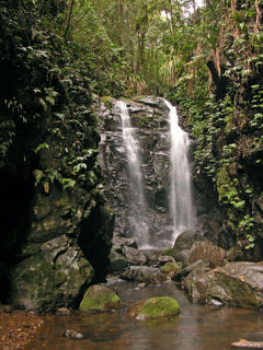
The Lamington National Park is a national park, lying on the Lamington Plateau of the McPherson Range on the Queensland/New South Wales border in Australia. From Southport on the Gold Coast the park is 85 kilometres (53 mi) to the southwest and Brisbane is 110 kilometres (68 mi) north. The 20,600 hectares Lamington National Park is known for its natural environment, rainforests, birdlife, ancient trees, waterfalls, walking tracks and mountain views.
The Mooloolah River National Park is a nationally protected area located on the Sunshine Coast, Queensland. It covers an area of 830.9 hectares and is bordered by the Mooloolah River to the east, Claymore and Dixon Roads to the west, and the Lower Mooloolah River Environmental Reserve to the south. It is bisected by the Sunshine Motorway with the northern, 161.93 hectare component of the Park being a later addition. The Park was initially vacant crown land prior to national park designation in 1960. Surrounding land uses include livestock grazing, urban development and the campus of the University of the Sunshine Coast. It is the second largest mainland park on the coastal lowlands in South East Queensland after Noosa National Park and represents an example of low-lying coastal floodplain distinctive of the region.
The Gondwana Rainforests of Australia, formerly known as the Central Eastern Rainforest Reserves, are the most extensive area of subtropical rainforest in the world. Collectively, the rainforests are a World Heritage Site with fifty separate reserves totalling 366,500 hectares from Newcastle to Brisbane.

The Wet Tropics of Queensland World Heritage Site consists of approximately 8,940 km2 of Australian wet tropical forests growing along the north-east Queensland portion of the Great Dividing Range. The Wet Tropics of Queensland meets all four of the criteria for natural heritage for selection as a World Heritage Site. World Heritage status was declared in 1988, and on 21 May 2007 the Wet Tropics were added to the Australian National Heritage List.

Kuranda is a rural town and locality on the Atherton Tableland in the Shire of Mareeba, Queensland, Australia. In the 2016 census, Kuranda had a population of 3,008 people. It is 25 kilometres (16 mi) from Cairns, via the Kuranda Range road. It is surrounded by tropical rainforest and adjacent to the Wet Tropics World Heritage listed Barron Gorge National Park.

The Barkly Tableland is a rolling plain of grassland in Australia. It runs from the eastern part of the Northern Territory into western Queensland. It is one of the five regions in the Northern Territory and covers 283,648 square kilometres (109,517 sq mi), 21% of the Northern Territory. The Barkly Tableland runs parallel to the southern shore of the Gulf of Carpentaria, from about Mount Isa, Queensland to near Daly Waters.

Totness Recreation Park is a protected area in the Australian state of South Australia located within the localities of Mount Barker and Totness in the central Mount Lofty Ranges. Covering 41 hectares of land, the park is divided by the South Eastern Freeway and features a large dam. It was declared as a reserve in 1970 and re-designated as a recreation park in 1972. The park has no visitor facilities except for access tracks. It is the only park in the district, managed by the Department of Environment and Water, that is solely designated for recreation.

The Northern Tablelands, also known as the New England Tableland, is a plateau and a region of the Great Dividing Range in northern New South Wales, Australia. It includes the New England Range, the narrow highlands area of the New England region, stretching from the Moonbi Range in the south to the Queensland border in the north. The region corresponds generally to the Bureau of Meteorology forecast area for the Northern Tablelands which in this case includes Inverell although it is significantly lower in elevation.

The Carnarvon Range is a mountain range in Central Queensland, Australia. It is a plateau section of the Great Dividing Range. The Carnarvon Range is 160 km in length.

Beeron National Park is a national park at Beeron in the Wide Bay–Burnett region of Queensland, Australia. The 7050-hectare park preserves plant species of high conservation value. It was formerly known as Beeron Holding or 'Rocky' paddock.
Kirrama National Park is a national park in Minnamoolka, Tablelands Region of Far North Queensland, Australia. The park protects rugged mountain landscapes, lush tropical rainforest and open eucalypt forests.

Mount Lewis National Park is national park in both the Shire of Mareeba and Douglas Shire of Far North Queensland, Australia. It is adjacent to both Daintree National Park and Mount Spurgeon National Park. It is part of the Wet Tropics of Queensland and Einasleigh Uplands bioregions. The park lies within the catchment areas of the Mitchell River, Mossman River and Daintree Rivers. Mount Lewis National Park preserves part of the Mount Carbine Tableland.

The Windsor Tablelands are a series of plateaus located in Far North Queensland, Australia. The Windsor Tableland and surrounding rainforest area are contained as part of the Wet Tropics of Queensland, sitting between the Daintree Rainforest and Mount Lewis National Park. Additionally, the region is contained in the state electorate of Cook and situated in the greater Tablelands Region of North Queensland. The Tablelands hug the mountain ranges of the Great Dividing Range with the nearest town being Wujal Wujal. The Tableland area is a larger part of the Mount Windsor Forest Reserve which represents 44,000 hectares of land in the Wet Tropic region and is a conserved nature area, as proclaimed by the Government of Queensland in 2005. Predominately the majority of the Mount Windsor Tableland is closed off for any form of public use and access to the area is often only given on request. There is currently no residential population in the Mount Windsor Tableland region as a majority of the area is national park.
