Toondah Harbour

Last updated

Toondah Harbour
Cleveland,  Queensland
Toondah Harbour From Public Boat Ramp , Cleveland, Queensland, 2014.JPG
Toondah Harbour

Toondah Harbour is a boat harbour at Cleveland in Redland City, Queensland, Australia. [1] It is in southern Moreton Bay. [2] It is the location of the Stradbroke Island Ferry Terminal used by water taxis and vehicular ferries to provide access to North Stradbroke Island.

Contents

History

Toondah Harbour is named after a vessel, the steamer "Toondah", which was used to survey and beacon channels in Moreton Bay. [3]

Vehicular ferry at Toondah Harbour Toondah Harbour Vehicular Ferry Embarkation.JPG
Vehicular ferry at Toondah Harbour
Dredging at Toondah Harbour Dredging the Fison Channel at Toondah Harbour.jpg
Dredging at Toondah Harbour
Bar-tailed godwit feeding near Toondah Harbour Bar-tailed godwit feeding on tidal mudflats near Toondah Harbour in Moreton Bay.JPG
Bar-tailed godwit feeding near Toondah Harbour

Geography

The harbour is situated south of Cleveland Point in an area of coastal wetlands featuring sandbanks, mudflats and mangroves. The area is naturally shallow but the Fison Channel has been dredged to provide access for vehicular ferries which connect Cleveland to Dunwich on North Stradbroke Island.

Cassim Island viewed from G.J. Walter Park, Cleveland Cassim Island at Sunrise viewed from G.J. Walter Park.JPG
Cassim Island viewed from G.J. Walter Park, Cleveland

Cassim Island, an area of sandbanks and mangroves located to the north of Toondah Harbour, provides shelter from northerly winds. The island is named after William Cassim, an early Cleveland hotel keeper. [4] Cassim Island provides a high value habitat for wading birds and other mangrove fauna. [5]

Environment

The marine and coastal area around the harbour are situated within internationally-significant wetlands, forming part of the Moreton Bay Ramsar site. [6] Tidal flats, mangroves and seagrass beds provide important habitats for fish, crustaceans, green turtles, loggerhead turtles, dugongs, and 43 species of shorebirds, including the vulnerable eastern curlew, the bar-tailed godwit and the grey-tailed tattler. [7] The region is also used by migratory birds as part of the East Asian–Australasian Flyway. [8] Endangered [9] southern right whales have been observed visiting the area annually since 2002. [10]

Development

Protest against plans to develop marina and high rise buildings in area around G.J. Walter Park, Cleveland, Queensland Protest against Toondah PDA plan 23 February 2014.jpg
Protest against plans to develop marina and high rise buildings in area around G.J. Walter Park, Cleveland, Queensland

Secret plans for a 400 berth marina, foreshore development and multi-level residential, retail and commercial developments were discussed by the Redland City Council in 2007 under former Mayor Don Secombe. [11]

On 10 January 2014 the Queensland Government released a proposed development scheme for the Toondah Harbour Priority Development Area in Cleveland which would allow development of a large marina up to 800 berths in southern Moreton Bay between Toondah Harbour, G.J. Walter Park and Cassim Island. [12] This proposal has been opposed by marine planning experts [13] and various environmentally concerned community groups including Wildlife Queensland - Bayside Branch. [14]

A number of Queensland architects and planners reviewed the scheme at an Urban Design Workshop. The workshop Convenor said the group found the current Toondah scheme "too large, unfeasible and risky". [15] He said the workshop recommended smaller developments across the city linking Raby Bay with Cleveland's CBD and the ferry terminal. [16] Inclement prevailing winds, traffic bottlenecking, flooding, site pollution, significant environmental complications and native title uncertainty are some of the risks identified for any real estate development in the Toondah Harbour area. [17]

On 23 February approximately 300 people attended a rally to protest against the Government's plans to "carve up" the G.J. Walter Park as part of its Toondah Harbour redevelopment proposal. [18] On 4 March 2014 a petition with 1,211 signatures calling for the Government's plans to be withdrawn was tabled in the Queensland Parliament. [19]

On 19 March the Council decided to ask the Queensland Government to make some changes to the plan which include reducing building heights from 15 storeys to 10 and a 400-berth marina at Toondah Harbour instead of 800 berths. [20] In March 2014 the Government indicated that it was preparing an amended development scheme. [21]

In April 2014 the Redland City Council released copies of various "expert reports" used to prepare the proposed development scheme together with revised artists impressions of the proposed development. [22]

On 31 May 2014 an approved development scheme was released [23] together with a lengthy report on the 583 submissions received during the consultation period. [24]

See also

Related Research Articles

<span class="mw-page-title-main">Moreton Bay</span> Inlet in southern Queensland, Australia

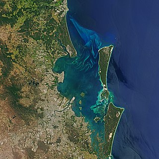
Moreton Bay is a bay located on the eastern coast of Australia 14 kilometres (8.7 mi) from central Brisbane, Queensland. It is one of Queensland's most important coastal resources. The waters of Moreton Bay are a popular destination for recreational anglers and are used by commercial operators who provide seafood to market.

<span class="mw-page-title-main">Cleveland railway line</span> Suburban railway line in Brisbane, Australia

The Cleveland railway line is a suburban railway line extending 37.3 kilometres (23.2 mi) east-southeast from Brisbane, the state capital of Queensland, Australia. It is part of the Queensland Rail City network.

<span class="mw-page-title-main">Stradbroke Island</span>

Stradbroke Island, also known as Minjerribah, was a large sand island that formed much of the eastern side of Moreton Bay near Brisbane, Queensland until the late 19th century. Today the island is split into two islands: North Stradbroke Island and South Stradbroke Island, separated by the Jumpinpin Channel.
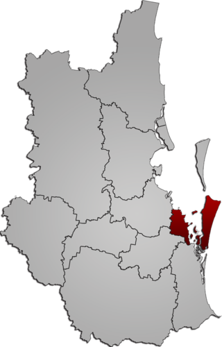
<span class="mw-page-title-main">North Stradbroke Island</span> Island that lies within Moreton Bay in the Australian state of Queensland

North Stradbroke Island, colloquially Straddie or North Straddie, is an island that lies within Moreton Bay in the Australian state of Queensland, 30 kilometres (19 mi) southeast of the centre of Brisbane. Originally there was only one Stradbroke Island but in 1896 it split into North Stradbroke Island and South Stradbroke Island separated by the Jumpinpin Channel. The Quandamooka people are the traditional owners of North Stradbroke island.

<span class="mw-page-title-main">Mount Cotton, Queensland</span> Locale in Queensland, Australia

Mount Cotton is a rural locality in the City of Redland, Queensland, Australia. In the 2016 census, Mount Cotton had a population of 6,835 people.

<span class="mw-page-title-main">Redland City</span> Local government area in Queensland, Australia

Redland City, better known as the Redlands and formerly known as Redland Shire, is a local government area and a part of the Brisbane metropolitan area in South East Queensland. With a population of 156,863 in June 2018, the city is spread along the southern coast of Moreton Bay, covering 537.2 square kilometres (207.4 sq mi). Its mainland borders the City of Brisbane to the west and north-west, and Logan City to the south-west and south, while its islands are situated north of the City of Gold Coast.

<span class="mw-page-title-main">Southern Moreton Bay Islands (Redland City)</span>

The Southern Moreton Bay Islands, abbreviated as the SMBI, also known as the Bay Islands, or the RKLM, are the four inhabited southern Moreton Bay islands located in South East Queensland, Australia. The group is part of the Redland City with a permanent population of 6,153 as of the 2016 census. However, nearly one-third of all dwellings on the islands were unoccupied, suggesting a high proportion of "second homes" that are owned by people who were elsewhere on the night of the census.

<span class="mw-page-title-main">Cleveland railway station</span> Railway station in Queensland, Australia

Cleveland railway station is located on the Cleveland line in Queensland, Australia. It serves the suburb of Cleveland in the Redland City.

Moreton Bay is a locality split between the City of Brisbane and the City of Redland, both in Queensland, Australia. The locality includes all of the bay Moreton Bay between the mainland of the City of Brisbane and the City of Redland across to the western coast of Moreton Island and the western coast of North Stradbroke Island. In the 2016 census, Moreton Bay had a population of 0 people.

<span class="mw-page-title-main">Cleveland, Queensland</span> Suburb of Redland City, Queensland, Australia

Cleveland is a coastal and central locality in the City of Redland, Queensland, Australia. In the 2016 census, Cleveland had a population of 14,801 people.

<span class="mw-page-title-main">Dunwich, Queensland</span> Town in Queensland, Australia

Dunwich is a town and locality on the western side of North Stradbroke Island in Queensland, Australia. Dunwich is part of the Redland City local government area, administered from the bayside town of Cleveland on the Queensland mainland. In the 2016 census, Dunwich had a population of 864 people.

<span class="mw-page-title-main">Leslie Harrison Dam</span> Dam in South East Queensland

The Leslie Harrison Dam is an earth-fill embankment dam across the Tingalpa Creek that is located in the South East region of Queensland, Australia. The main purpose of the dam is for potable water supply of the Redland City in Brisbane. The impounded reservoir is called Tingalpa Reservoir. The dam was named after Robert Leslie Harrison, a Queensland parliamentarian who died in April 1966.

Amity is a rural town and locality in the City of Redland, Queensland, Australia. In the 2016 census, the locality of Amity had a population of 387 people.

<span class="mw-page-title-main">Ferry transport in Queensland</span>

Ferry transport in Queensland provides both historical and current information relating to scheduled public passenger ferry services in Queensland. The first ferry started on 1 January 1843 at Russell Street with a service across the Brisbane River.

<span class="mw-page-title-main">Macleay Island</span> Town in Queensland, Australia

Macleay Island is an island in Moreton Bay, South East Queensland, Australia. The island constitutes a town and locality within the City of Redland. In the 2016 census, the locality of Macleay Island had a population of 2,681 people.

<span class="mw-page-title-main">Quandamooka people</span>

The Quandamooka people are Aboriginal Australians who live around Moreton Bay in Southeastern Queensland. They are composed of three distinct tribes, the Nunukul, the Goenpul and the Ngugi, and they live primarily on Moreton and North Stradbroke Islands, that form the eastern side of the bay. Many of them were pushed out of their lands when the English colonial government established a penal colony near there in 1824. Each group has its own language. A number of local food sources are utilised by the tribes.

<span class="mw-page-title-main">Cleveland Pioneer Cemetery</span> Historic site in Queensland, Australia

Cleveland Pioneer Cemetery is a heritage-listed cemetery at Lisa Street, Cleveland, City of Redland, Queensland, Australia. It is also known as Cleveland No.1 Cemetery. It was added to the Queensland Heritage Register on 18 September 2009.

<span class="mw-page-title-main">Cleveland Hotel</span> Historic site in Queensland, Australia

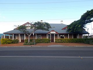
Cleveland Hotel is a heritage-listed former hotel at 109 Shore Street North, Cleveland, City of Redland, Queensland, Australia. It was built from c. 1860 to 1940s. It is also known as Cassim's Hotel and Sorrento Flats. It was added to the Queensland Heritage Register on 30 October 1995.

<span class="mw-page-title-main">Norfolk Island Pine Trees, Cleveland</span> Historic site in Queensland, Australia

The Norfolk Island Pine Trees are a heritage-listed group of trees at 127 Shore Street North, Cleveland, City of Redland, Queensland, Australia. They were added to the Queensland Heritage Register on 21 November 2003.

<span class="mw-page-title-main">Raby Bay</span>

Raby Bay is a bay within Moreton Bay, Queensland, Australia, created by the Cleveland Point headland. It forms the coastline of the suburbs of Cleveland and Ormiston in the City of Redland.

References

  1. "Toondah Harbour – harbour in Redland City (entry 34926)". Queensland Place Names. Queensland Government . Retrieved 23 July 2022.
  2. "Queensland Globe". State of Queensland . Retrieved 23 July 2022.
  3. Joshua Peter Bell, "Moreton Bay And How To Fathom It", Queensland Newspapers, 1984, p 52
  4. Joshua Peter Bell, "Moreton Bay And How To Fathom It", Queensland Newspapers, 1984, p 52
  5. Peter Davie et al, "Wild Guide To Moreton Bay", Queensland Museum, 1998, p 376
  6. Moreton Bay (Ramsar Site) Overview, Australian Government, Department of The Environment. Retrieved on 5 February 2014
  7. BAAM Ecological Consultants and FRC Environmental, "Expert Advice in Ecology (Marine and Terrestrial) and Coastal Processes for Input to the preparation of a Structure Plan and Development Scheme for Toondah Harbour and Weinam Creek Priority Development Areas", Retrieved 5 May 2014
  8. Migratory waterbirds, Australian Government, Department of The Environment. Retrieved 13 February 2014.
  9. Eubalaena australis — Southern Right Whale, Biodiversity - Species Profile and Threats Database, Australian Government Department of the Environment. Retrieved 18 August 2014
  10. Anne-Louise Brown, "Whale dead after horror boat strike", Brisbane Times, 17 August 2014. Retrieved 18 August 2014
  11. Daniel Hurst, "Secret council plan for Cleveland marina", Brisbane Times, 20 November 2007: http://www.brisbanetimes.com.au/news/queensland/secret-council-plan-for-cleveland-marina/2007/11/20/1195321743201.html, Retrieved 4 March 2014
  12. "Marina plan for Cleveland revamp", Brian Hurst, Bayside Bulletin, 13 January 2014 http://www.baysidebulletin.com.au/story/2017300/marina-plan-for-cleveland-revamp/, Retrieved 15 February 2014
  13. Judith Kerr, "Toondah proposals unviable say experts", Bayside Bulletin, 17 February 2014: http://www.baysidebulletin.com.au/story/2093169/toondah-proposalsunviable-say-experts/?cs=213, Retrieved 19 February 2014
  14. "Wildlife Queensland Bayside Branch".
  15. Judith Kerr, "Toondah think tank opts for Raby Bay", Bayside Bulletin, 3 March 2014: http://www.baysidebulletin.com.au/story/2123903/toondah-think-tank-opts-for-raby-bay-video/, Retrieved 10 June 2014
  16. Judith Kerr, "Crucial council vote on Toondah", Bayside Bulletin, 3 March 2014: http://www.baysidebulletin.com.au/story/2154986/crucial-council-vote-on-toondah/, Retrieved 10 June 2014
  17. Jackie Cooper, "Doris Day and the mudflats", Redlands2030 blog, 16 August 2014: http://redlands2030.net/?p=3303, Retrieved 16 August 2014
  18. "Future of GJ Walter Park defines Toondah debate", Bayside Bulletin, 24 February 2014, http://www.baysidebulletin.com.au/story/2106953/future-of-gj-walter-park-defines-toondah-debate/?cs=213, Retrieved on 25 February 2014
  19. Judith Kerr, "Petition calls on state to can Toondah scheme", Bayside Bulletin, 4 March 2014: http://www.baysidebulletin.com.au/story/2127473/petition-calls-on-state-to-can-toondah-scheme/?cs=213, Retrieved on 4 March 2014
  20. Judith Kerr, "Council limits Toondah building heights, marina", Bayside Bulletin, 19 March 2014: http://www.baysidebulletin.com.au/story/2161339/council-limits-toondah-building-heights-marina/ , Retrieved 3 April 2014
  21. Judith Kerr, "Toondah views to be considered", Bayside Bulletin, 31 March 2014: http://www.baysidebulletin.com.au/story/2186856/toondah-views-to-be-considered/?cs=213 , Retrieved 7 April 2014
  22. Judith Kerr, "Toondah and Weinam Creek expert reports released", Bayside Bulletin, 30 April 2014: http://www.baysidebulletin.com.au/story/2249797/toondah-and-weinam-creek-expert-reports-released/?cs=213, Retrieved 5 May 2014
  23. Toondah Harbour Priority Development Area Development Scheme May 2014: http://www.edq.qld.gov.au/resources/plan/pda/development-scheme-toondah-harbour.pdf, Retrieved 1 June 2014
  24. Toondah Harbour Priority Development Area Development Scheme Submissions Report, May 2014: http://www.edq.qld.gov.au/resources/plan/pda/submissions-report-toondah-harbour.pdf, Retrieved 1 June 2014

Commons-logo.svg Media related to Toondah Harbour at Wikimedia Commons

Coordinates: 27°32′S153°17′E / 27.533°S 153.283°E / -27.533; 153.283